About Igwisi Hills
Igwisi Hills is a pyroclastic cone(s) rising to 1,146 meters (3,760 feet) in Tanzania's Eastern Africa Volcanic Regions. No historical eruptions have been recorded, though the volcano is classified based on geological evidence of past activity. The volcano has produced 1 recorded eruption, with a maximum Volcanic Explosivity Index (VEI) of 1.
Geography & Climate
Igwisi Hills is located in Tanzania, within the Tanzania Craton Volcanic Province of the broader Eastern Africa Volcanic Regions. Situated at 4.89° S, 31.93° E in the Southern Hemisphere, the volcano lies within a tropical climate zone. With a summit elevation of 1,146 meters above sea level, Igwisi Hills is a moderately sized peak that remains accessible to hikers and researchers for much of the year. The volcanic landform is characterized as a minor, which describes the physical shape and structure of the volcanic edifice as observed from the surface.
Eruption History Summary
Igwisi Hills has 1 recorded eruption in the geological database, spanning from 10450 BCE to 10450 BCE. The most powerful recorded event was a gentle, effusive event in 10450 BCE, reaching VEI 1 on the Volcanic Explosivity Index.
GVP Reference Summary
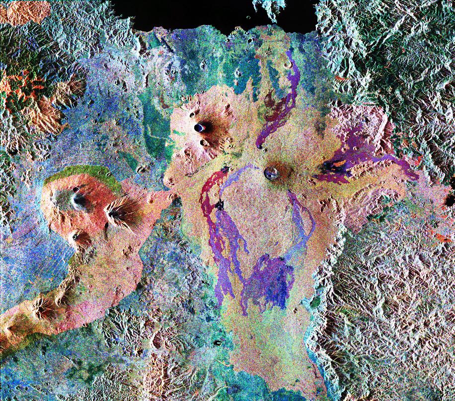
Three kimberlitic volcanoes of late Pleistocene or Holocene age are located in the Igwisi Hills, WNW of the city of Tabora in NW Tanzania. They were erupted along a NE-SW-trending rift through a Precambrian granitic gneiss basement and are located on the W side of the Tanzanian Craton far from volcanoes near the Gregory Rift. Two pyroclastic cones with well-preserved craters are present, with a central cone and crater adjacent to the NE crater that contains a solidified lava lake. The NE crater is the largest feature, at 370 m in diameter, and has been breached on the ENE side; this was the source of a lava flow about 1 km long and wide. The SW crater is also breached on the ENE side, with a smaller lava flow on the E flank. Cosmogenic 3He exposure dating of olivine in the lavas has a large uncertainty range, which Brown et al. (2012) variously describes as late Pleistocene/Holocene or "near Holocene" in their text.
— Smithsonian Institution, Global Volcanism Program
1 Recorded Eruption
| Year | VEI | Type | Area |
|---|---|---|---|
| 10450 BCE | 1 | Confirmed Eruption | NE Volcano |
Real-Time Data
Frequently Asked Questions About Igwisi Hills
Is Igwisi Hills an active volcano?+
Igwisi Hills is not currently classified as active. Its activity evidence is listed as "unknown." No recorded eruptions have been documented. However, no volcano is ever considered permanently extinct.
When did Igwisi Hills last erupt?+
The most recent recorded eruption of Igwisi Hills occurred in 10450 BCE with a Volcanic Explosivity Index (VEI) of 1. The eruption was classified as a "Confirmed Eruption." Igwisi Hills has 1 recorded eruption in total.
How high is Igwisi Hills?+
Igwisi Hills has a summit elevation of 1,146 meters (3,760 feet) above sea level. At 1,146 meters, it is a moderately sized volcanic peak, roughly comparable to Mount Vesuvius (1,281m).
What type of volcano is Igwisi Hills?+
Igwisi Hills is classified as a Pyroclastic cone(s). Pyroclastic cones (or cinder cones) are small, steep-sided volcanic cones built from fragments of lava blasted into the air. They are the simplest type of volcano and often form in groups.
Where is Igwisi Hills located?+
Igwisi Hills is located in Tanzania, in the Eastern Africa Volcanic Regions. More specifically, it lies within the Tanzania Craton Volcanic Province. Its exact coordinates are -4.889° latitude, 31.933° longitude.
Is it safe to visit Igwisi Hills?+
Igwisi Hills can generally be visited, but as with any volcano, visitors should check local conditions and any advisory notices before traveling. Tanzania may have specific regulations for accessing volcanic areas. Guided tours are often the safest and most informative way to experience a volcano.