About Maipo
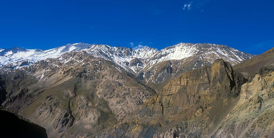
Maipo is a caldera rising to 5,323 meters (17,465 feet) in Chile-Argentina's South America Volcanic Regions. It last erupted in 1912 CE, and volcanologists consider it an active volcanic system. The volcano has produced 13 recorded eruptions, with a maximum Volcanic Explosivity Index (VEI) of 2.
Geography & Climate
Maipo is located in Chile-Argentina, within the Southern Andean Volcanic Arc of the broader South America Volcanic Regions. Situated at 34.16° S, 69.83° W in the Southern Hemisphere, the volcano lies within a subtropical climate zone. At 5,323 meters above sea level, Maipo reaches well into the permanent snow and ice zone. Glaciers and snowpack on the upper slopes create the potential for lahars — destructive volcanic mudflows — during eruptions, as heat rapidly melts ice and snow. The volcanic landform is characterized as a composite, which describes the physical shape and structure of the volcanic edifice as observed from the surface.
Geological Context
Maipo sits in a subduction zone, where one tectonic plate dives beneath another, creating intense heat and pressure that generates magma. Subduction zones are responsible for many of the world's most explosive volcanoes and deadliest eruptions. For communities in Chile-Argentina near Maipo, this tectonic setting means the volcano is capable of producing powerful explosive eruptions, pyroclastic flows, and lahars that can threaten populated areas within tens of kilometers of the summit. The dominant rock type is trachyandesite / basaltic trachyandesite, a dark, fine-grained volcanic rock that forms from rapidly cooling, low-viscosity lava. Basaltic eruptions tend to be less explosive and produce fluid lava flows that can travel long distances. While less immediately dangerous than explosive eruptions, basaltic lava flows can destroy structures and infrastructure in their path, and volcanic gases released during these eruptions can affect air quality over a wide area.
Eruption History Summary
Maipo has 13 recorded eruptions in the geological database, spanning from 1788 CE to 1912 CE. The most powerful recorded event was an explosive event producing ash plumes up to several kilometers in 1912 CE, reaching VEI 2 on the Volcanic Explosivity Index. This level of eruptive frequency indicates a persistently active volcanic system that warrants ongoing monitoring. The most recent eruption in 1912 CE places this volcano within the modern era of volcanological observation.
Significance
With 13 recorded eruptions, Maipo has a substantial eruptive history that provides valuable data for understanding volcanic behavior and assessing future hazards in the South America Volcanic Regions region.
GVP Reference Summary
Maipo, a conical stratovolcano that straddles the Chile-Argentina border SE of Santiago, partially fills the 16 x 20 km Pleistocene Diamante caldera, which formed about 450,000 years ago during an eruption that produced an about 350 km3 of rhyolitic ignimbrite. The Pleistocene cones of Volcán Don Casimiro and Cerro Listado were formed on the SW rim and SW flank of the caldera, respectively. The post-caldera Maipo rises about 1,900 m above the caldera floor, and has several cones on the E flank along a series of en échelon NE-trending fractures. Lava flows from one of these cones blocked drainages in 1826 inside the caldera, forming Lake Diamante on the eastern caldera floor.
— Smithsonian Institution, Global Volcanism Program
13 Recorded Eruptions
| Year | VEI | Type | Area |
|---|---|---|---|
| 1912 | 2 | Confirmed Eruption | — |
| 1908 | 2 | Uncertain Eruption | — |
| 1905 | 2 | Confirmed Eruption | — |
| 1881 | — | Uncertain Eruption | — |
| 1869 | 2 | Uncertain Eruption | — |
| 1837 | — | Uncertain Eruption | — |
| 1835 | — | Uncertain Eruption | — |
| 1833 | 2 | Uncertain Eruption | — |
| 1831 | 2 | Uncertain Eruption | — |
| 1829 | 2 | Confirmed Eruption | — |
| 1826 | 2 | Confirmed Eruption | East flank (Riso Patrón) |
| 1822 | — | Uncertain Eruption | — |
| 1788 | — | Uncertain Eruption | — |
Real-Time Data
Frequently Asked Questions About Maipo
Is Maipo an active volcano?+
Yes, Maipo is considered an active volcano. Its most recent eruption was in 1912 CE. The volcano is monitored by geological agencies, and its activity status is based on observed eruptions within recorded history.
When did Maipo last erupt?+
The most recent recorded eruption of Maipo occurred in 1912 CE with a Volcanic Explosivity Index (VEI) of 2. The eruption was classified as a "Confirmed Eruption." Maipo has 13 recorded eruptions in total.
How high is Maipo?+
Maipo has a summit elevation of 5,323 meters (17,465 feet) above sea level. At 5,323 meters, it stands taller than Mount Rainier (4,392m) and is among the world's major volcanic peaks.
What type of volcano is Maipo?+
Maipo is classified as a Caldera. Calderas are large volcanic depressions formed when a volcano erupts so powerfully that its magma chamber collapses, creating a basin that can be kilometers wide. They are often sites of some of Earth's largest eruptions.
Where is Maipo located?+
Maipo is located in Chile-Argentina, in the South America Volcanic Regions. More specifically, it lies within the Southern Andean Volcanic Arc. Its exact coordinates are -34.164° latitude, -69.832° longitude.
Is it safe to visit Maipo?+
Visiting Maipo requires checking current volcanic activity and alert levels. As an active volcano with eruptions as recent as 1912 CE, conditions can change rapidly. Always consult local geological authorities and follow official warnings before visiting. Many active volcanoes have designated safe viewing areas and guided tour options.