About Huaynaputina
Huaynaputina is a stratovolcano rising to 4,679 meters (15,352 feet) in Peru's South America Volcanic Regions. Its last known eruption was in 1600 CE. The volcano has produced 2 recorded eruptions, with a maximum Volcanic Explosivity Index (VEI) of 6.
Geography & Climate
Huaynaputina is located in Peru, within the Central Andean Volcanic Arc of the broader South America Volcanic Regions. Situated at 16.61° S, 70.85° W in the Southern Hemisphere, the volcano lies within a tropical climate zone. Standing at 4,679 meters above sea level, Huaynaputina towers above the alpine zone, where vegetation gives way to bare rock, snow, and ice for much of the year. The high elevation means the upper slopes experience significantly colder temperatures than surrounding lowlands. The volcanic landform is characterized as a composite, which describes the physical shape and structure of the volcanic edifice as observed from the surface.
Geological Context
Huaynaputina sits in a subduction zone, where one tectonic plate dives beneath another, creating intense heat and pressure that generates magma. Subduction zones are responsible for many of the world's most explosive volcanoes and deadliest eruptions. For communities in Peru near Huaynaputina, this tectonic setting means the volcano is capable of producing powerful explosive eruptions, pyroclastic flows, and lahars that can threaten populated areas within tens of kilometers of the summit. The dominant rock type is dacite, an intermediate to silica-rich volcanic rock. This composition typically produces more viscous magma, leading to more explosive eruptions with ash columns and pyroclastic flows. Andesitic and dacitic magmas build pressure before erupting, which is why volcanoes with this rock chemistry are often associated with Plinian-style eruptions that can send ash tens of kilometers into the atmosphere and disrupt aviation across entire regions.
Eruption History Summary
Huaynaputina has 2 recorded eruptions in the geological database, spanning from 7750 BCE to 1600 CE. The most powerful recorded event was a colossal eruption capable of affecting global climate for years in 1600 CE, reaching VEI 6 on the Volcanic Explosivity Index. These eruptions span roughly 9,350 years of volcanic history.
Significance
Huaynaputina has produced at least one eruption of VEI 6 or higher, placing it among the most powerful volcanic systems on Earth. Eruptions of this magnitude inject massive quantities of sulfur dioxide into the stratosphere, affecting global climate by lowering average temperatures for one to three years after the event.
GVP Reference Summary
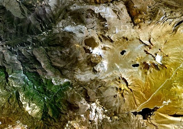
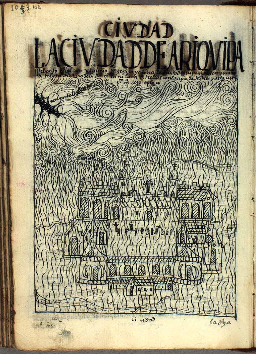
Huaynaputina (whose name means "new volcano") was the source of the largest historical eruption of South America in 1600 CE. It has no prominent topographic expression and lies within a 2.5-km-wide collapse depression and further excavated by glaciers within a Tertiary to Pleistocene edifice. Three overlapping ash cones with craters up to 100 m deep were constructed during the 1600 CE eruption on the floor of the older crater, whose outer flanks are heavily mantled by ash deposits from the 1600 eruption. This powerful fissure-fed eruption may have produced nearly 30 km3 of dacitic tephra, including pyroclastic flows and surges that traveled 13 km to the E and SE. Lahars reached the Pacific Ocean, 120 km away. The eruption caused substantial damage to the major cities of Arequipa and Moquengua.
— Smithsonian Institution, Global Volcanism Program
2 Recorded Eruptions
| Year | VEI | Type | Area |
|---|---|---|---|
| 1600 | 6 | Confirmed Eruption | Summit and south flank |
| 7750 BCE | — | Confirmed Eruption | — |
Real-Time Data
Frequently Asked Questions About Huaynaputina
Is Huaynaputina an active volcano?+
Huaynaputina is classified as active based on credible evidence of past eruptions. Although its last known eruption was in 1600 CE, volcanologists consider it capable of erupting again.
When did Huaynaputina last erupt?+
The most recent recorded eruption of Huaynaputina occurred in 1600 CE with a Volcanic Explosivity Index (VEI) of 6. The eruption was classified as a "Confirmed Eruption." Huaynaputina has 2 recorded eruptions in total.
How high is Huaynaputina?+
Huaynaputina has a summit elevation of 4,679 meters (15,352 feet) above sea level. At 4,679 meters, it stands taller than Mount Rainier (4,392m) and is among the world's major volcanic peaks.
What type of volcano is Huaynaputina?+
Huaynaputina is classified as a Stratovolcano. Stratovolcanoes (also called composite volcanoes) are steep, conical volcanoes built up by many layers of hardened lava, tephra, and volcanic ash. They are among the most common and dangerous types, known for explosive eruptions.
Where is Huaynaputina located?+
Huaynaputina is located in Peru, in the South America Volcanic Regions. More specifically, it lies within the Central Andean Volcanic Arc. Its exact coordinates are -16.614° latitude, -70.854° longitude.
Is it safe to visit Huaynaputina?+
Huaynaputina can generally be visited, but as with any volcano, visitors should check local conditions and any advisory notices before traveling. Peru may have specific regulations for accessing volcanic areas. Guided tours are often the safest and most informative way to experience a volcano.