About Alcedo
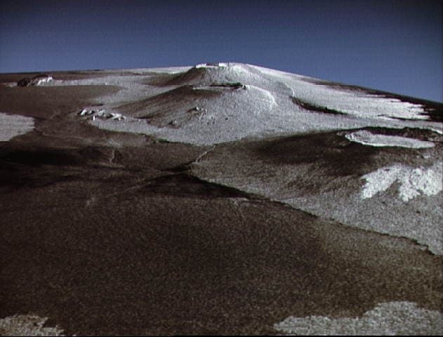
Alcedo is a shield rising to 1,130 meters (3,708 feet) in Ecuador's Eastern Pacific Volcanic Regions. It last erupted in 1993 CE, and volcanologists consider it an active volcanic system. The volcano has produced 2 recorded eruptions, with a maximum Volcanic Explosivity Index (VEI) of 1.
Geography & Climate
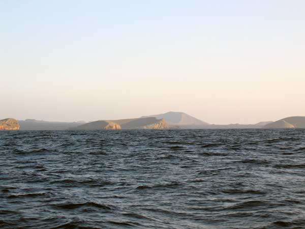
Alcedo is located in Ecuador, within the Galapagos Hotspot Volcano Group of the broader Eastern Pacific Volcanic Regions. Situated at 0.43° S, 91.12° W in the Southern Hemisphere, the volcano lies within a tropical climate zone. With a summit elevation of 1,130 meters above sea level, Alcedo is a moderately sized peak that remains accessible to hikers and researchers for much of the year. The volcanic landform is characterized as a shield, which describes the physical shape and structure of the volcanic edifice as observed from the surface.
Geological Context
Alcedo is situated along a rift zone, where tectonic plates are pulling apart. As the crust thins and fractures, magma rises to fill the gap, creating volcanic activity. Rift volcanism typically produces more fluid lava flows rather than explosive blasts, which means communities near Alcedo in Ecuador generally face slower-moving hazards like lava flows and ground fissures rather than sudden pyroclastic events. However, rift volcanoes can still generate significant ash emissions and gas releases that affect local air quality. The dominant rock type is basalt / picro-basalt, a dark, fine-grained volcanic rock that forms from rapidly cooling, low-viscosity lava. Basaltic eruptions tend to be less explosive and produce fluid lava flows that can travel long distances. While less immediately dangerous than explosive eruptions, basaltic lava flows can destroy structures and infrastructure in their path, and volcanic gases released during these eruptions can affect air quality over a wide area.
Eruption History Summary
Alcedo has 2 recorded eruptions in the geological database, spanning from 1953 CE to 1993 CE. The most powerful recorded event was a gentle, effusive event in 1993 CE, reaching VEI 1 on the Volcanic Explosivity Index. These eruptions span roughly 40 years of volcanic history. The most recent eruption in 1993 CE places this volcano within the modern era of volcanological observation.
GVP Reference Summary
Alcedo is one of the lowest and smallest of six shield volcanoes on Isabela Island. Much of the flanks and summit caldera are vegetated, but young lava flows are prominent on the N flank near the saddle with Darwin volcano. It is the only Galapagos volcano known to have erupted rhyolite as well as basalt, producing about 1 km3 of late-Pleistocene rhyolitic tephra and lava flows from several vents late in its history. Recent faulting has produced a moat around part of the 7-8 km caldera floor, which is elongated N-S and appears to be migrating to the south. Fewer circumferential fissures occur on Alcedo than on other western Galápagos volcanoes. An eruption attributed to Alcedo in 1954 (Richards, 1957) is more likely to have been from neighboring Sierra Negra (Simkin 1980, pers. comm.). Photo-geologic mapping by K.A. Howard (pers. comm.) revealed only one flow on 30 October 1960 photographs that does not appear on 30 May 1946 photos. That is near Cartago Bay, low on the SE flank, rather than the 610-m, NE-flank elevation listed for the 1954 eruption. An active hydrothermal system is located within the caldera.
— Smithsonian Institution, Global Volcanism Program
2 Recorded Eruptions
| Year | VEI | Type | Area |
|---|---|---|---|
| 1993 | 1 | Confirmed Eruption | South caldera wall |
| 1953 | 0 | Confirmed Eruption | SE flank near Cartago Bay |
Real-Time Data
Frequently Asked Questions About Alcedo
Is Alcedo an active volcano?+
Yes, Alcedo is considered an active volcano. Its most recent eruption was in 1993 CE. The volcano is monitored by geological agencies, and its activity status is based on observed eruptions within recorded history.
When did Alcedo last erupt?+
The most recent recorded eruption of Alcedo occurred in 1993 CE with a Volcanic Explosivity Index (VEI) of 1. The eruption was classified as a "Confirmed Eruption." Alcedo has 2 recorded eruptions in total.
How high is Alcedo?+
Alcedo has a summit elevation of 1,130 meters (3,708 feet) above sea level. At 1,130 meters, it is a moderately sized volcanic peak, roughly comparable to Mount Vesuvius (1,281m).
What type of volcano is Alcedo?+
Alcedo is classified as a Shield. Shield volcanoes have distinct geological characteristics that set them apart from other volcanic types.
Where is Alcedo located?+
Alcedo is located in Ecuador, in the Eastern Pacific Volcanic Regions. More specifically, it lies within the Galapagos Hotspot Volcano Group. Its exact coordinates are -0.430° latitude, -91.120° longitude.
Is it safe to visit Alcedo?+
Visiting Alcedo requires checking current volcanic activity and alert levels. As an active volcano with eruptions as recent as 1993 CE, conditions can change rapidly. Always consult local geological authorities and follow official warnings before visiting. Many active volcanoes have designated safe viewing areas and guided tour options.