About Darwin
Darwin is a shield rising to 1,330 meters (4,364 feet) in Ecuador's Eastern Pacific Volcanic Regions. Its last known eruption was in 1813 CE. The volcano has produced 3 recorded eruptions, with a maximum Volcanic Explosivity Index (VEI) of 2.
Geography & Climate
Darwin is located in Ecuador, within the Galapagos Hotspot Volcano Group of the broader Eastern Pacific Volcanic Regions. Situated at 0.18° S, 91.28° W in the Southern Hemisphere, the volcano lies within a tropical climate zone. With a summit elevation of 1,330 meters above sea level, Darwin is a moderately sized peak that remains accessible to hikers and researchers for much of the year. The volcanic landform is characterized as a shield, which describes the physical shape and structure of the volcanic edifice as observed from the surface.
Geological Context
Darwin is situated along a rift zone, where tectonic plates are pulling apart. As the crust thins and fractures, magma rises to fill the gap, creating volcanic activity. Rift volcanism typically produces more fluid lava flows rather than explosive blasts, which means communities near Darwin in Ecuador generally face slower-moving hazards like lava flows and ground fissures rather than sudden pyroclastic events. However, rift volcanoes can still generate significant ash emissions and gas releases that affect local air quality. The dominant rock type is basalt / picro-basalt, a dark, fine-grained volcanic rock that forms from rapidly cooling, low-viscosity lava. Basaltic eruptions tend to be less explosive and produce fluid lava flows that can travel long distances. While less immediately dangerous than explosive eruptions, basaltic lava flows can destroy structures and infrastructure in their path, and volcanic gases released during these eruptions can affect air quality over a wide area.
Eruption History Summary
Darwin has 3 recorded eruptions in the geological database, spanning from 210 CE to 1813 CE. The most powerful recorded event was an explosive event producing ash plumes up to several kilometers in 1813 CE, reaching VEI 2 on the Volcanic Explosivity Index. These eruptions span roughly 1,603 years of volcanic history.
GVP Reference Summary
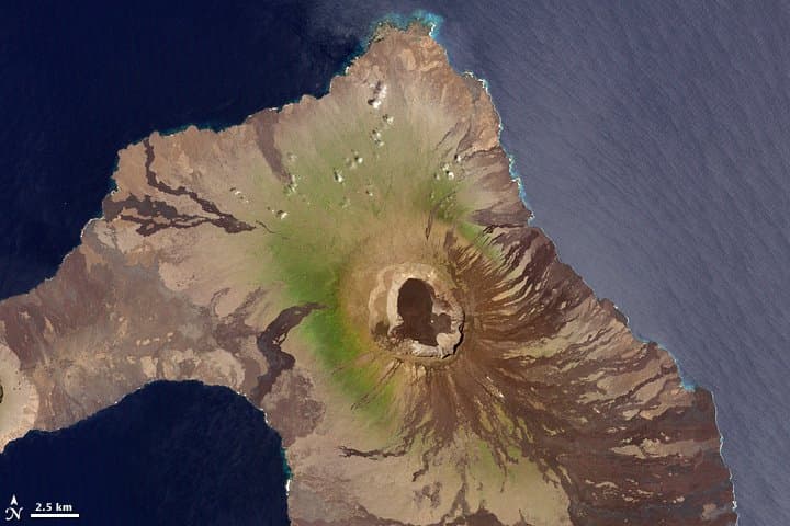
Volcán Darwin, named after the renowned naturalist, contains a symmetrical 5-km-wide, 200-m-deep summit caldera whose floor is nearly covered by youthful lava flows. A broad terrace occupies the SW part of the caldera. Fresh-looking, unvegetated lava flows descend all flanks and reach both the eastern and western coasts. The most recent summit activity produced several small lava flows from vents on the east caldera floor and NE and SE caldera rims. Radial fissures descend the flanks, and one reaches beyond its base to the the SW coast and cuts Tagus tuff cone. The sheltered anchorage of Tagus Cove breaches the southern side of the cone and was visited by Darwin and other noted visitors. This prominent tuff cone and its neighbor Beagle (also breached to the south) are located on the SW-flank coastline and were a prominent part of Darwin's geological studies in the Galápagos Islands.
— Smithsonian Institution, Global Volcanism Program
3 Recorded Eruptions
| Year | VEI | Type | Area |
|---|---|---|---|
| 1813 | 2 | Confirmed Eruption | Volcano Uncertain: more likely Darwin than Wolf, Alcedo |
| 1150 | 0 | Confirmed Eruption | — |
| 210 | 0 | Confirmed Eruption | — |
Real-Time Data
Frequently Asked Questions About Darwin
Is Darwin an active volcano?+
Darwin is not currently classified as active. Its activity evidence is listed as "Eruption Dated." The last known eruption was in 1813 CE. However, no volcano is ever considered permanently extinct.
When did Darwin last erupt?+
The most recent recorded eruption of Darwin occurred in 1813 CE with a Volcanic Explosivity Index (VEI) of 2. The eruption was classified as a "Confirmed Eruption." Darwin has 3 recorded eruptions in total.
How high is Darwin?+
Darwin has a summit elevation of 1,330 meters (4,364 feet) above sea level. At 1,330 meters, it is a moderately sized volcanic peak, roughly comparable to Mount Vesuvius (1,281m).
What type of volcano is Darwin?+
Darwin is classified as a Shield. Shield volcanoes have distinct geological characteristics that set them apart from other volcanic types.
Where is Darwin located?+
Darwin is located in Ecuador, in the Eastern Pacific Volcanic Regions. More specifically, it lies within the Galapagos Hotspot Volcano Group. Its exact coordinates are -0.180° latitude, -91.280° longitude.
Is it safe to visit Darwin?+
Darwin can generally be visited, but as with any volcano, visitors should check local conditions and any advisory notices before traveling. Ecuador may have specific regulations for accessing volcanic areas. Guided tours are often the safest and most informative way to experience a volcano.