About San Vicente
San Vicente is a stratovolcano rising to 2,149 meters (7,051 feet) in El Salvador's Middle America-Caribbean Volcanic Regions. No historical eruptions have been recorded, though the volcano is classified based on geological evidence of past activity.
Geography & Climate
San Vicente is located in El Salvador, within the Central America Volcanic Arc of the broader Middle America-Caribbean Volcanic Regions. Situated at 13.60° N, 88.84° W in the Northern Hemisphere, the volcano lies within a tropical climate zone. At 2,149 meters above sea level, San Vicente rises above the surrounding terrain into montane or subalpine conditions. The elevation creates distinct ecological zones along its flanks, from forested lower slopes to exposed rocky terrain near the summit. The volcanic landform is characterized as a composite, which describes the physical shape and structure of the volcanic edifice as observed from the surface.
Geological Context
San Vicente sits in a subduction zone, where one tectonic plate dives beneath another, creating intense heat and pressure that generates magma. Subduction zones are responsible for many of the world's most explosive volcanoes and deadliest eruptions. For communities in El Salvador near San Vicente, this tectonic setting means the volcano is capable of producing powerful explosive eruptions, pyroclastic flows, and lahars that can threaten populated areas within tens of kilometers of the summit. The dominant rock type is andesite / basaltic andesite, a dark, fine-grained volcanic rock that forms from rapidly cooling, low-viscosity lava. Basaltic eruptions tend to be less explosive and produce fluid lava flows that can travel long distances. While less immediately dangerous than explosive eruptions, basaltic lava flows can destroy structures and infrastructure in their path, and volcanic gases released during these eruptions can affect air quality over a wide area.
GVP Reference Summary
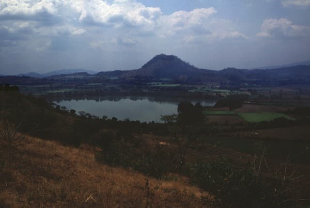
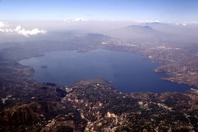
San Vicente stratovolcano, also known as Chichontepec, is ~20 km SE of Lake Ilopango. The andesitic edifice with two summit peaks was constructed within the Pleistocene La Carbonera caldera, whose rim is visible only on its SW side. The N and S flanks are covered by lava flows from the central vent, but lava flows on the eastern side originated from a vent on the upper flank. Volcanism has continued into the Holocene, but the latest lava flows are covered by deposits from the major Tierra Blanca eruption from Ilopango around 450 CE. Reports of eruptions in 1643 CE and 1835 CE are false (Catalog of Active Volcanoes of the World; Sapper, 1917), but numerous hot springs and fumaroles are found on the N and W flanks.
— Smithsonian Institution, Global Volcanism Program
0 Recorded Eruptions
No eruption records available for San Vicente.
Real-Time Data
Frequently Asked Questions About San Vicente
Is San Vicente an active volcano?+
San Vicente is classified as active based on credible evidence of past eruptions. Although its last known eruption was in prehistoric times, volcanologists consider it capable of erupting again.
How high is San Vicente?+
San Vicente has a summit elevation of 2,149 meters (7,051 feet) above sea level. At 2,149 meters, it is comparable in height to many significant mountain peaks and stands well above the tree line.
What type of volcano is San Vicente?+
San Vicente is classified as a Stratovolcano. Stratovolcanoes (also called composite volcanoes) are steep, conical volcanoes built up by many layers of hardened lava, tephra, and volcanic ash. They are among the most common and dangerous types, known for explosive eruptions.
Where is San Vicente located?+
San Vicente is located in El Salvador, in the Middle America-Caribbean Volcanic Regions. More specifically, it lies within the Central America Volcanic Arc. Its exact coordinates are 13.597° latitude, -88.838° longitude.
Is it safe to visit San Vicente?+
San Vicente can generally be visited, but as with any volcano, visitors should check local conditions and any advisory notices before traveling. El Salvador may have specific regulations for accessing volcanic areas. Guided tours are often the safest and most informative way to experience a volcano.