About Ilopango
Ilopango is a caldera rising to 450 meters (1,476 feet) in El Salvador's Middle America-Caribbean Volcanic Regions. Its last known eruption was in 1880 CE. The volcano has produced 2 recorded eruptions, with a maximum Volcanic Explosivity Index (VEI) of 6.
Geography & Climate
Ilopango is located in El Salvador, within the Central America Volcanic Arc of the broader Middle America-Caribbean Volcanic Regions. Situated at 13.67° N, 89.05° W in the Northern Hemisphere, the volcano lies within a tropical climate zone. At just 450 meters above sea level, Ilopango is a relatively low-elevation volcanic feature. Despite its modest height, it remains an active geological formation with the same underlying magmatic processes as its taller counterparts. The volcanic landform is characterized as a caldera, which describes the physical shape and structure of the volcanic edifice as observed from the surface.
Geological Context
Ilopango sits in a subduction zone, where one tectonic plate dives beneath another, creating intense heat and pressure that generates magma. Subduction zones are responsible for many of the world's most explosive volcanoes and deadliest eruptions. For communities in El Salvador near Ilopango, this tectonic setting means the volcano is capable of producing powerful explosive eruptions, pyroclastic flows, and lahars that can threaten populated areas within tens of kilometers of the summit. The dominant rock type is dacite, an intermediate to silica-rich volcanic rock. This composition typically produces more viscous magma, leading to more explosive eruptions with ash columns and pyroclastic flows. Andesitic and dacitic magmas build pressure before erupting, which is why volcanoes with this rock chemistry are often associated with Plinian-style eruptions that can send ash tens of kilometers into the atmosphere and disrupt aviation across entire regions.
Eruption History Summary
Ilopango has 2 recorded eruptions in the geological database, spanning from 450 CE to 1879 CE. The most powerful recorded event was a colossal eruption capable of affecting global climate for years in 450 CE, reaching VEI 6 on the Volcanic Explosivity Index. Notable eruptions include 1879 CE (VEI 3), 450 CE (VEI 6). These eruptions span roughly 1,429 years of volcanic history.
Significance
Ilopango has produced at least one eruption of VEI 6 or higher, placing it among the most powerful volcanic systems on Earth. Eruptions of this magnitude inject massive quantities of sulfur dioxide into the stratosphere, affecting global climate by lowering average temperatures for one to three years after the event.
GVP Reference Summary
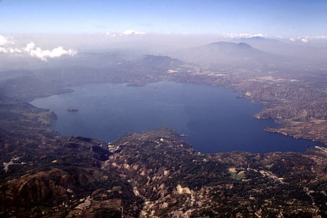
The 8 x 11 km Ilopango caldera, filled by one of El Salvador's largest lakes, has a scalloped 150-500 m high rim. The caldera, which lies immediately east of the capital city of San Salvador, is strongly controlled by regional faults of the central Salvador graben. Four major dacitic-rhyolitic explosive eruptions during the late Pleistocene and Holocene produced pyroclastic-flow and pyroclastic-fall deposits that cover much of El Salvador. The latest collapse resulted from the massive 5th century CE Tierra Blanca Joven (TBJ) eruption, which produced widespread pyroclastic flows and devastated early Mayan cities. Post-caldera eruptions formed a series of glassy dacitic and andesitic lava domes within the lake and near its shore. The Islas Quemadas, a group of low islets in the center of the lake that mark the summit of a largely submerged lava dome, were formed during an eruption in 1879-80.
— Smithsonian Institution, Global Volcanism Program
2 Recorded Eruptions
| Year | VEI | Type | Area |
|---|---|---|---|
| 1879 | 3 | Confirmed Eruption | Islas Quemadas, Lake Ilopango |
| 450 | 6 | Confirmed Eruption | — |
Real-Time Data
Frequently Asked Questions About Ilopango
Is Ilopango an active volcano?+
Ilopango is classified as active based on credible evidence of past eruptions. Although its last known eruption was in 1880 CE, volcanologists consider it capable of erupting again.
When did Ilopango last erupt?+
The most recent recorded eruption of Ilopango occurred in 1879 CE with a Volcanic Explosivity Index (VEI) of 3. The eruption was classified as a "Confirmed Eruption." Ilopango has 2 recorded eruptions in total.
How high is Ilopango?+
Ilopango has a summit elevation of 450 meters (1,476 feet) above sea level. At 450 meters, it is a relatively low-elevation volcano.
What type of volcano is Ilopango?+
Ilopango is classified as a Caldera. Calderas are large volcanic depressions formed when a volcano erupts so powerfully that its magma chamber collapses, creating a basin that can be kilometers wide. They are often sites of some of Earth's largest eruptions.
Where is Ilopango located?+
Ilopango is located in El Salvador, in the Middle America-Caribbean Volcanic Regions. More specifically, it lies within the Central America Volcanic Arc. Its exact coordinates are 13.672° latitude, -89.053° longitude.
Is it safe to visit Ilopango?+
Ilopango can generally be visited, but as with any volcano, visitors should check local conditions and any advisory notices before traveling. El Salvador may have specific regulations for accessing volcanic areas. Guided tours are often the safest and most informative way to experience a volcano.


