About Apaneca Range
Apaneca Range is a stratovolcano(es) rising to 2,028 meters (6,654 feet) in El Salvador's Middle America-Caribbean Volcanic Regions. No historical eruptions have been recorded, though the volcano is classified based on geological evidence of past activity.
Geography & Climate
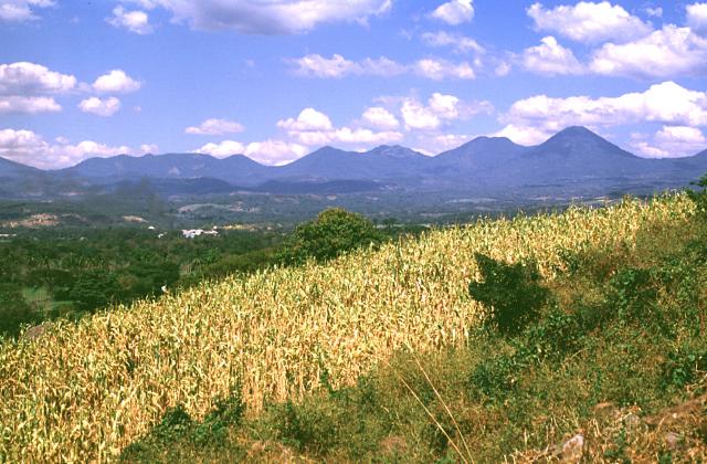
Apaneca Range is located in El Salvador, within the Central America Volcanic Arc of the broader Middle America-Caribbean Volcanic Regions. Situated at 13.87° N, 89.74° W in the Northern Hemisphere, the volcano lies within a tropical climate zone. At 2,028 meters above sea level, Apaneca Range rises above the surrounding terrain into montane or subalpine conditions. The elevation creates distinct ecological zones along its flanks, from forested lower slopes to exposed rocky terrain near the summit. The volcanic landform is characterized as a composite, which describes the physical shape and structure of the volcanic edifice as observed from the surface.
Geological Context
Apaneca Range sits in a subduction zone, where one tectonic plate dives beneath another, creating intense heat and pressure that generates magma. Subduction zones are responsible for many of the world's most explosive volcanoes and deadliest eruptions. For communities in El Salvador near Apaneca Range, this tectonic setting means the volcano is capable of producing powerful explosive eruptions, pyroclastic flows, and lahars that can threaten populated areas within tens of kilometers of the summit. The dominant rock type is basalt / picro-basalt, a dark, fine-grained volcanic rock that forms from rapidly cooling, low-viscosity lava. Basaltic eruptions tend to be less explosive and produce fluid lava flows that can travel long distances. While less immediately dangerous than explosive eruptions, basaltic lava flows can destroy structures and infrastructure in their path, and volcanic gases released during these eruptions can affect air quality over a wide area.
GVP Reference Summary
The Apaneca Range (also known as the Cuyanausul Range) consists of a group of basaltic-to-andesitic Pleistocene and Holocene stratovolcanoes in western El Salvador between the Santa Ana complex and the Guatemala border. The Pleistocene dacitic-rhyolitic Concepción de Ataco caldera (5 x 3.5 km) lies at the W end of the complex, along with post-caldera late-Pleistocene to Holocene andesitic-dacitic lava domes. The post-caldera cones of Cerro el Aguila (the highest peak of the complex) and Cerro los Naranjos at the E end of the chain were mapped as Holocene by Weber and Weisemann (1978). Young craters on the basaltic Cerro Laguna Verde stratovolcano may also have been active during the Holocene. Numerous fumarole fields are located on the N flank of the range, and the Ahuachapán geothermal field has been producing since 1975. Several small hydrothermal explosions have occurred in historical time, including one in October 1990 at the Agua Shuca thermal area in which 26 people were killed.
— Smithsonian Institution, Global Volcanism Program
0 Recorded Eruptions
No eruption records available for Apaneca Range.
Real-Time Data
Frequently Asked Questions About Apaneca Range
Is Apaneca Range an active volcano?+
Apaneca Range is classified as active based on credible evidence of past eruptions. Although its last known eruption was in prehistoric times, volcanologists consider it capable of erupting again.
How high is Apaneca Range?+
Apaneca Range has a summit elevation of 2,028 meters (6,654 feet) above sea level. At 2,028 meters, it is comparable in height to many significant mountain peaks and stands well above the tree line.
What type of volcano is Apaneca Range?+
Apaneca Range is classified as a Stratovolcano(es). Stratovolcano(es) volcanoes have distinct geological characteristics that set them apart from other volcanic types.
Where is Apaneca Range located?+
Apaneca Range is located in El Salvador, in the Middle America-Caribbean Volcanic Regions. More specifically, it lies within the Central America Volcanic Arc. Its exact coordinates are 13.872° latitude, -89.742° longitude.
Is it safe to visit Apaneca Range?+
Apaneca Range can generally be visited, but as with any volcano, visitors should check local conditions and any advisory notices before traveling. El Salvador may have specific regulations for accessing volcanic areas. Guided tours are often the safest and most informative way to experience a volcano.


