About Fuego
Fuego is a stratovolcano(es) rising to 3,799 meters (12,465 feet) in Guatemala's Middle America-Caribbean Volcanic Regions. The volcano is currently active, with its most recent eruption in 2025 CE. The volcano has produced 20 recorded eruptions, with a maximum Volcanic Explosivity Index (VEI) of 4.
Geography & Climate
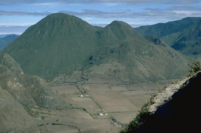
Fuego is located in Guatemala, within the Central America Volcanic Arc of the broader Middle America-Caribbean Volcanic Regions. Situated at 14.47° N, 90.88° W in the Northern Hemisphere, the volcano lies within a tropical climate zone. Standing at 3,799 meters above sea level, Fuego towers above the alpine zone, where vegetation gives way to bare rock, snow, and ice for much of the year. The high elevation means the upper slopes experience significantly colder temperatures than surrounding lowlands. The volcanic landform is characterized as a composite, which describes the physical shape and structure of the volcanic edifice as observed from the surface.
Geological Context
Fuego sits in a subduction zone, where one tectonic plate dives beneath another, creating intense heat and pressure that generates magma. Subduction zones are responsible for many of the world's most explosive volcanoes and deadliest eruptions. For communities in Guatemala near Fuego, this tectonic setting means the volcano is capable of producing powerful explosive eruptions, pyroclastic flows, and lahars that can threaten populated areas within tens of kilometers of the summit. The dominant rock type is basalt / picro-basalt, a dark, fine-grained volcanic rock that forms from rapidly cooling, low-viscosity lava. Basaltic eruptions tend to be less explosive and produce fluid lava flows that can travel long distances. While less immediately dangerous than explosive eruptions, basaltic lava flows can destroy structures and infrastructure in their path, and volcanic gases released during these eruptions can affect air quality over a wide area.
Eruption History Summary
Fuego has 20 recorded eruptions in the geological database, spanning from 1944 CE to 2002 CE. The most powerful recorded event was a cataclysmic eruption with ash columns reaching the stratosphere in 1974 CE, reaching VEI 4 on the Volcanic Explosivity Index. Notable eruptions include 2002 CE (VEI 3), 1974 CE (VEI 4), 1971 CE (VEI 3). With an average interval of roughly 3 years between eruptions over a span of 58 years, this is one of the more frequently active volcanoes in the database. This persistent activity suggests a robust and well-supplied magma system beneath the volcano. With eruptive activity as recently as 2002 CE, Fuego remains an actively monitored volcano.
Significance
With a maximum recorded VEI of 4, Fuego has demonstrated the capacity for significant explosive eruptions that can impact regional aviation, agriculture, and communities tens of kilometers from the summit. VEI 4 eruptions produce ash columns reaching 15-25 kilometers into the atmosphere. Its 20 recorded eruptions make it one of the most prolific volcanoes in our database, reflecting a persistent and well-documented eruptive history that has provided volcanologists with extensive data for understanding eruption patterns and forecasting future activity. Given its recent activity, Fuego is closely monitored by geological survey organizations to provide early warning of future unrest.
GVP Reference Summary
Volcán Fuego, one of Central America's most active volcanoes, is also one of three large stratovolcanoes overlooking Guatemala's former capital, Antigua. The scarp of an older edifice, Meseta, lies between Fuego and Acatenango to the north. Construction of Meseta dates back to about 230,000 years and continued until the late Pleistocene or early Holocene. Collapse of Meseta may have produced the massive Escuintla debris-avalanche deposit, which extends about 50 km onto the Pacific coastal plain. Growth of the modern Fuego volcano followed, continuing the southward migration of volcanism that began at the mostly andesitic Acatenango. Eruptions at Fuego have become more mafic with time, and most historical activity has produced basaltic rocks. Frequent vigorous eruptions have been recorded since the onset of the Spanish era in 1524, and have produced major ashfalls, along with occasional pyroclastic flows and lava flows.
— Smithsonian Institution, Global Volcanism Program
20 Recorded Eruptions
| Year | VEI | Type | Area |
|---|---|---|---|
| 2002 | 3 | Confirmed Eruption | — |
| 1999 | 2 | Confirmed Eruption | — |
| 1987 | 1 | Confirmed Eruption | — |
| 1977 | 1 | Confirmed Eruption | — |
| 1977 | 2 | Confirmed Eruption | — |
| 1975 | 1 | Confirmed Eruption | — |
| 1974 | 4 | Confirmed Eruption | — |
| 1973 | 2 | Confirmed Eruption | — |
| 1971 | 3 | Confirmed Eruption | — |
| 1967 | 2 | Confirmed Eruption | — |
| 1966 | 3 | Confirmed Eruption | — |
| 1966 | 3 | Confirmed Eruption | — |
| 1963 | 3 | Confirmed Eruption | — |
| 1962 | 3 | Confirmed Eruption | — |
| 1957 | 3 | Confirmed Eruption | — |
| 1955 | 1 | Confirmed Eruption | — |
| 1953 | 3 | Confirmed Eruption | — |
| 1949 | 2 | Confirmed Eruption | — |
| 1947 | 2 | Confirmed Eruption | — |
| 1944 | 2 | Confirmed Eruption | — |
Real-Time Data
Frequently Asked Questions About Fuego
Is Fuego an active volcano?+
Yes, Fuego is considered an active volcano. Its most recent eruption was in 2025 CE. The volcano is monitored by geological agencies, and its activity status is based on observed eruptions within recorded history.
When did Fuego last erupt?+
The most recent recorded eruption of Fuego occurred in 2002 CE with a Volcanic Explosivity Index (VEI) of 3. The eruption was classified as a "Confirmed Eruption." Fuego has 20 recorded eruptions in total.
How high is Fuego?+
Fuego has a summit elevation of 3,799 meters (12,465 feet) above sea level. At 3,799 meters, it is comparable in height to many significant mountain peaks and stands well above the tree line.
What type of volcano is Fuego?+
Fuego is classified as a Stratovolcano(es). Stratovolcano(es) volcanoes have distinct geological characteristics that set them apart from other volcanic types.
Where is Fuego located?+
Fuego is located in Guatemala, in the Middle America-Caribbean Volcanic Regions. More specifically, it lies within the Central America Volcanic Arc. Its exact coordinates are 14.475° latitude, -90.881° longitude.
Is it safe to visit Fuego?+
Visiting Fuego requires checking current volcanic activity and alert levels. As an active volcano with eruptions as recent as 2025 CE, conditions can change rapidly. Always consult local geological authorities and follow official warnings before visiting. Many active volcanoes have designated safe viewing areas and guided tour options.