About Acatenango
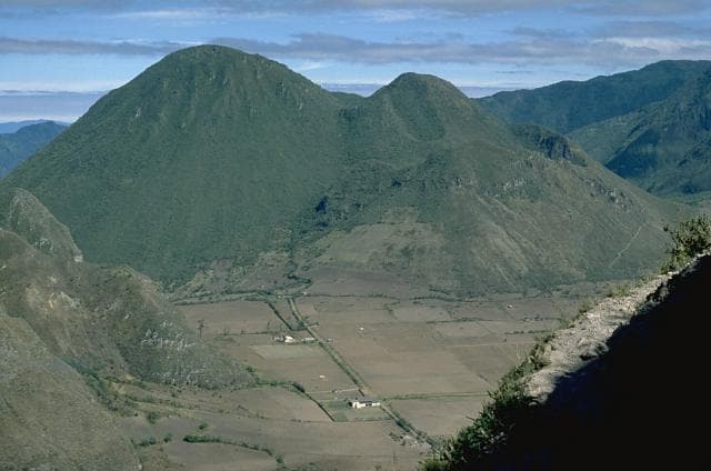
Acatenango is a stratovolcano(es) rising to 3,976 meters (13,045 feet) in Guatemala's Middle America-Caribbean Volcanic Regions. It last erupted in 1972 CE, and volcanologists consider it an active volcanic system. The volcano has produced 8 recorded eruptions, with a maximum Volcanic Explosivity Index (VEI) of 3.
Geography & Climate
Acatenango is located in Guatemala, within the Central America Volcanic Arc of the broader Middle America-Caribbean Volcanic Regions. Situated at 14.50° N, 90.88° W in the Northern Hemisphere, the volcano lies within a tropical climate zone. Standing at 3,976 meters above sea level, Acatenango towers above the alpine zone, where vegetation gives way to bare rock, snow, and ice for much of the year. The high elevation means the upper slopes experience significantly colder temperatures than surrounding lowlands. The volcanic landform is characterized as a composite, which describes the physical shape and structure of the volcanic edifice as observed from the surface.
Geological Context
Acatenango sits in a subduction zone, where one tectonic plate dives beneath another, creating intense heat and pressure that generates magma. Subduction zones are responsible for many of the world's most explosive volcanoes and deadliest eruptions. For communities in Guatemala near Acatenango, this tectonic setting means the volcano is capable of producing powerful explosive eruptions, pyroclastic flows, and lahars that can threaten populated areas within tens of kilometers of the summit. The dominant rock type is andesite / basaltic andesite, a dark, fine-grained volcanic rock that forms from rapidly cooling, low-viscosity lava. Basaltic eruptions tend to be less explosive and produce fluid lava flows that can travel long distances. While less immediately dangerous than explosive eruptions, basaltic lava flows can destroy structures and infrastructure in their path, and volcanic gases released during these eruptions can affect air quality over a wide area.
Eruption History Summary
Acatenango has 8 recorded eruptions in the geological database, spanning from 2710 BCE to 1972 CE. The most powerful recorded event was a severe eruption capable of regional ash fall and pyroclastic flows in 1924 CE, reaching VEI 3 on the Volcanic Explosivity Index. This eruption frequency indicates a moderately active volcanic system with periodic reawakenings. The most recent eruption in 1972 CE places this volcano within the modern era of volcanological observation.
Significance
With a maximum recorded VEI of 3, Acatenango has produced eruptions capable of generating pyroclastic flows and significant ash fall in the surrounding area. While not among the largest eruptions globally, VEI 3 events pose serious hazards to local populations and can disrupt regional air travel. With 8 recorded eruptions on file, Acatenango has enough documented activity to help scientists identify patterns in its eruptive behavior. Given its recent activity, Acatenango is closely monitored by geological survey organizations to provide early warning of future unrest.
GVP Reference Summary
Acatenango is ~15 km SW of the city of Antigua, Guatemala, and 3 km N of Fuego volcano. Both edifices were constructed during three eruptive periods post-dating the roughly 85,000-year-old Los Chocoyos tephra from Atitlán caldera. An older Acatenango edifice collapsed to the south sometime prior to 43,000 years ago, forming La Democracia debris-avalanche deposit, which covers a wide area of the Pacific coastal plain. Construction of the Yepocapa cone, ~900 m N of the main crater, was completed about 20,000 years ago, after which growth of the larger southern cone, Pico Central (also known as Pico Mayor), began. The first well-documented eruptions took place from 1924 to 1927 CE. Francisco Vasquez, writing in 1690 CE, noted that in 1661 a volcano that lay aside of Fuego "opened a smoking mouth and still gives off smoke from another three, but without noise."
— Smithsonian Institution, Global Volcanism Program
8 Recorded Eruptions
| Year | VEI | Type | Area |
|---|---|---|---|
| 1972 | 1 | Confirmed Eruption | Pico Central-Yepocapa saddle |
| 1926 | 2 | Confirmed Eruption | Pico Central |
| 1924 | 3 | Confirmed Eruption | North slope of Pico Central |
| 1450 | — | Confirmed Eruption | — |
| 90 | — | Confirmed Eruption | Pico Central |
| 260 BCE | — | Confirmed Eruption | Pico Central |
| 370 BCE | — | Confirmed Eruption | Pico Central |
| 2710 BCE | — | Confirmed Eruption | Yepocapa |
Real-Time Data
Frequently Asked Questions About Acatenango
Is Acatenango an active volcano?+
Yes, Acatenango is considered an active volcano. Its most recent eruption was in 1972 CE. The volcano is monitored by geological agencies, and its activity status is based on observed eruptions within recorded history.
When did Acatenango last erupt?+
The most recent recorded eruption of Acatenango occurred in 1972 CE with a Volcanic Explosivity Index (VEI) of 1. The eruption was classified as a "Confirmed Eruption." Acatenango has 8 recorded eruptions in total.
How high is Acatenango?+
Acatenango has a summit elevation of 3,976 meters (13,045 feet) above sea level. At 3,976 meters, it is comparable in height to many significant mountain peaks and stands well above the tree line.
What type of volcano is Acatenango?+
Acatenango is classified as a Stratovolcano(es). Stratovolcano(es) volcanoes have distinct geological characteristics that set them apart from other volcanic types.
Where is Acatenango located?+
Acatenango is located in Guatemala, in the Middle America-Caribbean Volcanic Regions. More specifically, it lies within the Central America Volcanic Arc. Its exact coordinates are 14.501° latitude, -90.876° longitude.
Is it safe to visit Acatenango?+
Visiting Acatenango requires checking current volcanic activity and alert levels. As an active volcano with eruptions as recent as 1972 CE, conditions can change rapidly. Always consult local geological authorities and follow official warnings before visiting. Many active volcanoes have designated safe viewing areas and guided tour options.