About Malinche, La
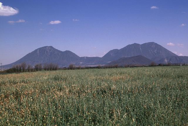
Malinche, La is a stratovolcano rising to 4,461 meters (14,637 feet) in Mexico's Middle America-Caribbean Volcanic Regions. Its last known eruption dates to 1170 BCE, in prehistoric times. The volcano has produced 7 recorded eruptions.
Geography & Climate
Malinche, La is located in Mexico, within the Trans-Mexican Volcanic Arc of the broader Middle America-Caribbean Volcanic Regions. Situated at 19.23° N, 98.03° W in the Northern Hemisphere, the volcano lies within a tropical climate zone. Standing at 4,461 meters above sea level, Malinche, La towers above the alpine zone, where vegetation gives way to bare rock, snow, and ice for much of the year. The high elevation means the upper slopes experience significantly colder temperatures than surrounding lowlands. The volcanic landform is characterized as a composite, which describes the physical shape and structure of the volcanic edifice as observed from the surface.
Geological Context
Malinche, La sits in a subduction zone, where one tectonic plate dives beneath another, creating intense heat and pressure that generates magma. Subduction zones are responsible for many of the world's most explosive volcanoes and deadliest eruptions. For communities in Mexico near Malinche, La, this tectonic setting means the volcano is capable of producing powerful explosive eruptions, pyroclastic flows, and lahars that can threaten populated areas within tens of kilometers of the summit. The dominant rock type is andesite / basaltic andesite, a dark, fine-grained volcanic rock that forms from rapidly cooling, low-viscosity lava. Basaltic eruptions tend to be less explosive and produce fluid lava flows that can travel long distances. While less immediately dangerous than explosive eruptions, basaltic lava flows can destroy structures and infrastructure in their path, and volcanic gases released during these eruptions can affect air quality over a wide area.
Eruption History Summary
Malinche, La has 7 recorded eruptions in the geological database, spanning from 6890 BCE to 1170 BCE. This eruption frequency indicates a moderately active volcanic system with periodic reawakenings.
Significance
With 7 recorded eruptions on file, Malinche, La has enough documented activity to help scientists identify patterns in its eruptive behavior.
GVP Reference Summary
La Malinche is an eroded stratovolcano, cut by deep canyons, NE of the city of Puebla. It occupies an isolated position between the Popocatépetl-Iztaccíhuatl and Orizaba-Cofre de Perote volcanic ranges. Much of the andesitic-dacitic volcano was constructed during the Pleistocene, and the summit exhibits evidence of glacial erosion. Although relatively unstudied, research has identified Holocene tephra layers that originated from Volcán la Malinche. Several cones and explosion craters, at least one of Holocene age, are found on the flanks; one of the most prominent of these is the Xalapaxco maar complex on the lower ENE flank. Holocene lahars associated with an eruption about 3,100 years ago reached the Puebla basin and affected communities there.
— Smithsonian Institution, Global Volcanism Program
7 Recorded Eruptions
| Year | VEI | Type | Area |
|---|---|---|---|
| 1170 BCE | — | Confirmed Eruption | — |
| 5580 BCE | — | Confirmed Eruption | — |
| 5870 BCE | — | Confirmed Eruption | — |
| 6120 BCE | — | Confirmed Eruption | — |
| 6310 BCE | — | Confirmed Eruption | — |
| 6710 BCE | — | Confirmed Eruption | — |
| 6890 BCE | — | Confirmed Eruption | — |
Real-Time Data
Frequently Asked Questions About Malinche, La
Is Malinche, La an active volcano?+
Malinche, La is not currently classified as active. Its activity evidence is listed as "Eruption Dated." The last known eruption was in 1170 BCE. However, no volcano is ever considered permanently extinct.
When did Malinche, La last erupt?+
The most recent recorded eruption of Malinche, La occurred in 1170 BCE. The eruption was classified as a "Confirmed Eruption." Malinche, La has 7 recorded eruptions in total.
How high is Malinche, La?+
Malinche, La has a summit elevation of 4,461 meters (14,637 feet) above sea level. At 4,461 meters, it stands taller than Mount Rainier (4,392m) and is among the world's major volcanic peaks.
What type of volcano is Malinche, La?+
Malinche, La is classified as a Stratovolcano. Stratovolcanoes (also called composite volcanoes) are steep, conical volcanoes built up by many layers of hardened lava, tephra, and volcanic ash. They are among the most common and dangerous types, known for explosive eruptions.
Where is Malinche, La located?+
Malinche, La is located in Mexico, in the Middle America-Caribbean Volcanic Regions. More specifically, it lies within the Trans-Mexican Volcanic Arc. Its exact coordinates are 19.231° latitude, -98.032° longitude.
Is it safe to visit Malinche, La?+
Malinche, La can generally be visited, but as with any volcano, visitors should check local conditions and any advisory notices before traveling. Mexico may have specific regulations for accessing volcanic areas. Guided tours are often the safest and most informative way to experience a volcano.