About Michoacan-Guanajuato
Michoacan-Guanajuato is a volcanic field rising to 3,860 meters (12,665 feet) in Mexico's Middle America-Caribbean Volcanic Regions. It last erupted in 1952 CE, and volcanologists consider it an active volcanic system. The volcano has produced 11 recorded eruptions, with a maximum Volcanic Explosivity Index (VEI) of 4.
Geography & Climate
Michoacan-Guanajuato is located in Mexico, within the Trans-Mexican Volcanic Arc of the broader Middle America-Caribbean Volcanic Regions. Situated at 19.85° N, 101.75° W in the Northern Hemisphere, the volcano lies within a tropical climate zone. Standing at 3,860 meters above sea level, Michoacan-Guanajuato towers above the alpine zone, where vegetation gives way to bare rock, snow, and ice for much of the year. The high elevation means the upper slopes experience significantly colder temperatures than surrounding lowlands. The volcanic landform is characterized as a cluster, which describes the physical shape and structure of the volcanic edifice as observed from the surface.
Geological Context
Michoacan-Guanajuato sits in a subduction zone, where one tectonic plate dives beneath another, creating intense heat and pressure that generates magma. Subduction zones are responsible for many of the world's most explosive volcanoes and deadliest eruptions. For communities in Mexico near Michoacan-Guanajuato, this tectonic setting means the volcano is capable of producing powerful explosive eruptions, pyroclastic flows, and lahars that can threaten populated areas within tens of kilometers of the summit. The dominant rock type is andesite / basaltic andesite, a dark, fine-grained volcanic rock that forms from rapidly cooling, low-viscosity lava. Basaltic eruptions tend to be less explosive and produce fluid lava flows that can travel long distances. While less immediately dangerous than explosive eruptions, basaltic lava flows can destroy structures and infrastructure in their path, and volcanic gases released during these eruptions can affect air quality over a wide area.
Eruption History Summary
Michoacan-Guanajuato has 11 recorded eruptions in the geological database, spanning from 7350 BCE to 1943 CE. The most powerful recorded event was a cataclysmic eruption with ash columns reaching the stratosphere in 1943 CE, reaching VEI 4 on the Volcanic Explosivity Index. Notable eruptions include 1943 CE (VEI 4), 1759 CE (VEI 4), 1880 BCE (VEI 3). This level of eruptive frequency indicates a persistently active volcanic system that warrants ongoing monitoring. The most recent eruption in 1943 CE places this volcano within the modern era of volcanological observation.
Significance
With a maximum recorded VEI of 4, Michoacan-Guanajuato has demonstrated the capacity for significant explosive eruptions that can impact regional aviation, agriculture, and communities tens of kilometers from the summit. VEI 4 eruptions produce ash columns reaching 15-25 kilometers into the atmosphere. With 11 recorded eruptions, Michoacan-Guanajuato has a substantial eruptive history that provides valuable data for understanding volcanic behavior and assessing future hazards in the Middle America-Caribbean Volcanic Regions region.
GVP Reference Summary
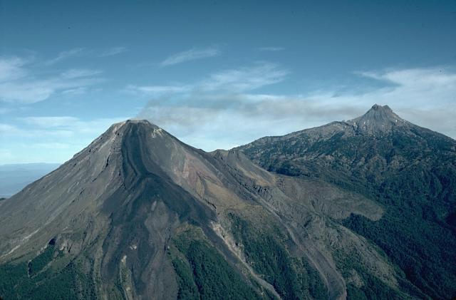
The widespread Michoacán-Guanajuato volcanic field contains over 1,400 vents, including the historically active cinder cones of Parícutin and Jorullo, covering a 200 x 250 km wide area of Michoacán and Guanajuato states in west-central México. Cinder cones are the predominant volcanic form, but small shield volcanoes, lava domes, maars and tuff rings (many in the Valle de Santiago area), and coneless lava flows are also present. The volcanoes with shield-type morphologies are mostly Pleistocene in age, although the Michoacán-Guanajuato centers have higher slope angles and smaller basal diameters. Jorullo, which was constructed in the 18th century, and Parícutin, which grew above a former cornfield during 1943-52, are the two best known volcanic features scattered throughout the field.
— Smithsonian Institution, Global Volcanism Program
11 Recorded Eruptions
| Year | VEI | Type | Area |
|---|---|---|---|
| 1943 | 4 | Confirmed Eruption | Parícutin |
| 1759 | 4 | Confirmed Eruption | Jorullo |
| 1050 | — | Uncertain Eruption | Valle de Santiago |
| 1140 BCE | — | Confirmed Eruption | Cerro el Zoyate |
| 1880 BCE | 3 | Confirmed Eruption | Cerro el Jabalí |
| 2050 BCE | — | Confirmed Eruption | Valle de Santiago (La Alberca) |
| 2750 BCE | 3 | Confirmed Eruption | Cerro el Metate |
| 4140 BCE | — | Confirmed Eruption | Cerro la Tinaja |
| 5940 BCE | — | Confirmed Eruption | Cerro Grande? |
| 6480 BCE | 3 | Confirmed Eruption | Cerro la Taza |
| 7350 BCE | 3 | Confirmed Eruption | Hoyo el Huanillo |
Real-Time Data
Frequently Asked Questions About Michoacan-Guanajuato
Is Michoacan-Guanajuato an active volcano?+
Yes, Michoacan-Guanajuato is considered an active volcano. Its most recent eruption was in 1952 CE. The volcano is monitored by geological agencies, and its activity status is based on observed eruptions within recorded history.
When did Michoacan-Guanajuato last erupt?+
The most recent recorded eruption of Michoacan-Guanajuato occurred in 1943 CE with a Volcanic Explosivity Index (VEI) of 4. The eruption was classified as a "Confirmed Eruption." Michoacan-Guanajuato has 11 recorded eruptions in total.
How high is Michoacan-Guanajuato?+
Michoacan-Guanajuato has a summit elevation of 3,860 meters (12,665 feet) above sea level. At 3,860 meters, it is comparable in height to many significant mountain peaks and stands well above the tree line.
What type of volcano is Michoacan-Guanajuato?+
Michoacan-Guanajuato is classified as a Volcanic field. Volcanic fields consist of clusters of small volcanic vents and cinder cones spread across a region. Rather than a single central vent, eruptions can occur at many points across the field.
Where is Michoacan-Guanajuato located?+
Michoacan-Guanajuato is located in Mexico, in the Middle America-Caribbean Volcanic Regions. More specifically, it lies within the Trans-Mexican Volcanic Arc. Its exact coordinates are 19.850° latitude, -101.750° longitude.
Is it safe to visit Michoacan-Guanajuato?+
Visiting Michoacan-Guanajuato requires checking current volcanic activity and alert levels. As an active volcano with eruptions as recent as 1952 CE, conditions can change rapidly. Always consult local geological authorities and follow official warnings before visiting. Many active volcanoes have designated safe viewing areas and guided tour options.