About Colima
Colima is a stratovolcano(es) rising to 3,850 meters (12,632 feet) in Mexico's Middle America-Caribbean Volcanic Regions. It has been active in recent decades, with its last eruption in 2019 CE. The volcano has produced 20 recorded eruptions, with a maximum Volcanic Explosivity Index (VEI) of 4.
Geography & Climate
Colima is located in Mexico, within the Trans-Mexican Volcanic Arc of the broader Middle America-Caribbean Volcanic Regions. Situated at 19.51° N, 103.62° W in the Northern Hemisphere, the volcano lies within a tropical climate zone. Standing at 3,850 meters above sea level, Colima towers above the alpine zone, where vegetation gives way to bare rock, snow, and ice for much of the year. The high elevation means the upper slopes experience significantly colder temperatures than surrounding lowlands. The volcanic landform is characterized as a composite, which describes the physical shape and structure of the volcanic edifice as observed from the surface.
Geological Context
Colima sits in a subduction zone, where one tectonic plate dives beneath another, creating intense heat and pressure that generates magma. Subduction zones are responsible for many of the world's most explosive volcanoes and deadliest eruptions. For communities in Mexico near Colima, this tectonic setting means the volcano is capable of producing powerful explosive eruptions, pyroclastic flows, and lahars that can threaten populated areas within tens of kilometers of the summit. The dominant rock type is andesite / basaltic andesite, a dark, fine-grained volcanic rock that forms from rapidly cooling, low-viscosity lava. Basaltic eruptions tend to be less explosive and produce fluid lava flows that can travel long distances. While less immediately dangerous than explosive eruptions, basaltic lava flows can destroy structures and infrastructure in their path, and volcanic gases released during these eruptions can affect air quality over a wide area.
Eruption History Summary
Colima has 20 recorded eruptions in the geological database, spanning from 1904 CE to 2019 CE. The most powerful recorded event was a cataclysmic eruption with ash columns reaching the stratosphere in 1913 CE, reaching VEI 4 on the Volcanic Explosivity Index. Notable eruptions include 2013 CE (VEI 3), 1997 CE (VEI 3), 1913 CE (VEI 4). With an average interval of roughly 6 years between eruptions over a span of 115 years, this is one of the more frequently active volcanoes in the database. This persistent activity suggests a robust and well-supplied magma system beneath the volcano. With eruptive activity as recently as 2019 CE, Colima remains an actively monitored volcano.
Significance
With a maximum recorded VEI of 4, Colima has demonstrated the capacity for significant explosive eruptions that can impact regional aviation, agriculture, and communities tens of kilometers from the summit. VEI 4 eruptions produce ash columns reaching 15-25 kilometers into the atmosphere. Its 20 recorded eruptions make it one of the most prolific volcanoes in our database, reflecting a persistent and well-documented eruptive history that has provided volcanologists with extensive data for understanding eruption patterns and forecasting future activity. Given its recent activity, Colima is closely monitored by geological survey organizations to provide early warning of future unrest.
GVP Reference Summary
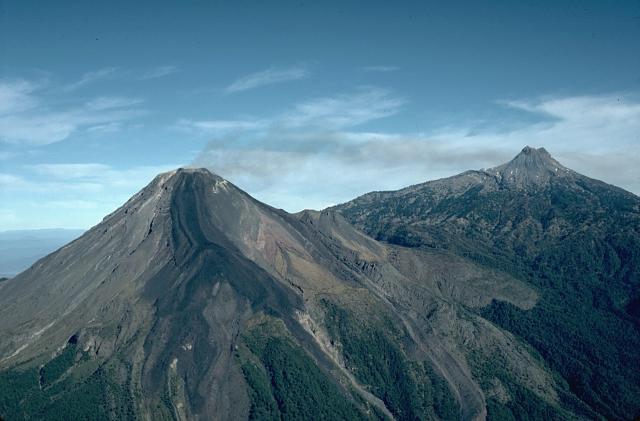
The Colima complex is the most prominent volcanic center of the western Mexican Volcanic Belt. It consists of two southward-younging volcanoes, Nevado de Colima (the high point of the complex) on the north and the historically active Volcán de Colima at the south. A group of late-Pleistocene cinder cones is located on the floor of the Colima graben west and east of the complex. Volcán de Colima (also known as Volcán Fuego) is a youthful stratovolcano constructed within a 5-km-wide scarp, breached to the south, that has been the source of large debris avalanches. Major slope failures have occurred repeatedly from both the Nevado and Colima cones, producing thick debris-avalanche deposits on three sides of the complex. Frequent recorded eruptions date back to the 16th century. Occasional major explosive eruptions have destroyed the summit (most recently in 1913) and left a deep, steep-sided crater that was slowly refilled and then overtopped by lava dome growth.
— Smithsonian Institution, Global Volcanism Program
20 Recorded Eruptions
| Year | VEI | Type | Area |
|---|---|---|---|
| 2019 | 1 | Confirmed Eruption | — |
| 2013 | 3 | Confirmed Eruption | Summit crater |
| 1997 | 3 | Confirmed Eruption | 1994 crater |
| 1994 | 1 | Confirmed Eruption | West of 1987 explosion crater |
| 1991 | 2 | Confirmed Eruption | — |
| 1988 | 2 | Uncertain Eruption | — |
| 1987 | 1 | Confirmed Eruption | East side of summit lava dome |
| 1985 | 1 | Confirmed Eruption | — |
| 1983 | 1 | Uncertain Eruption | — |
| 1977 | 1 | Confirmed Eruption | — |
| 1975 | 2 | Confirmed Eruption | — |
| 1973 | 1 | Uncertain Eruption | — |
| 1963 | 1 | Confirmed Eruption | — |
| 1961 | 1 | Confirmed Eruption | — |
| 1957 | 1 | Confirmed Eruption | — |
| 1941 | 3 | Uncertain Eruption | — |
| 1926 | 1 | Confirmed Eruption | — |
| 1913 | 4 | Confirmed Eruption | — |
| 1908 | 3 | Confirmed Eruption | — |
| 1904 | 1 | Confirmed Eruption | — |
Real-Time Data
Frequently Asked Questions About Colima
Is Colima an active volcano?+
Yes, Colima is considered an active volcano. Its most recent eruption was in 2019 CE. The volcano is monitored by geological agencies, and its activity status is based on observed eruptions within recorded history.
When did Colima last erupt?+
The most recent recorded eruption of Colima occurred in 2019 CE with a Volcanic Explosivity Index (VEI) of 1. The eruption was classified as a "Confirmed Eruption." Colima has 20 recorded eruptions in total.
How high is Colima?+
Colima has a summit elevation of 3,850 meters (12,632 feet) above sea level. At 3,850 meters, it is comparable in height to many significant mountain peaks and stands well above the tree line.
What type of volcano is Colima?+
Colima is classified as a Stratovolcano(es). Stratovolcano(es) volcanoes have distinct geological characteristics that set them apart from other volcanic types.
Where is Colima located?+
Colima is located in Mexico, in the Middle America-Caribbean Volcanic Regions. More specifically, it lies within the Trans-Mexican Volcanic Arc. Its exact coordinates are 19.514° latitude, -103.620° longitude.
Is it safe to visit Colima?+
Visiting Colima requires checking current volcanic activity and alert levels. As an active volcano with eruptions as recent as 2019 CE, conditions can change rapidly. Always consult local geological authorities and follow official warnings before visiting. Many active volcanoes have designated safe viewing areas and guided tour options.


