About Ceboruco
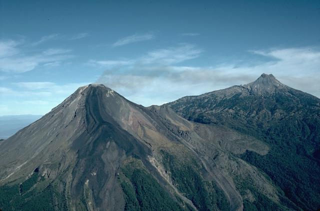
Ceboruco is a stratovolcano rising to 2,280 meters (7,481 feet) in Mexico's Middle America-Caribbean Volcanic Regions. Its last known eruption was in 1875 CE. The volcano has produced 4 recorded eruptions, with a maximum Volcanic Explosivity Index (VEI) of 6.
Geography & Climate
Ceboruco is located in Mexico, within the Trans-Mexican Volcanic Arc of the broader Middle America-Caribbean Volcanic Regions. Situated at 21.13° N, 104.51° W in the Northern Hemisphere, the volcano lies within a tropical climate zone. At 2,280 meters above sea level, Ceboruco rises above the surrounding terrain into montane or subalpine conditions. The elevation creates distinct ecological zones along its flanks, from forested lower slopes to exposed rocky terrain near the summit. The volcanic landform is characterized as a composite, which describes the physical shape and structure of the volcanic edifice as observed from the surface.
Geological Context
Ceboruco sits in a subduction zone, where one tectonic plate dives beneath another, creating intense heat and pressure that generates magma. Subduction zones are responsible for many of the world's most explosive volcanoes and deadliest eruptions. For communities in Mexico near Ceboruco, this tectonic setting means the volcano is capable of producing powerful explosive eruptions, pyroclastic flows, and lahars that can threaten populated areas within tens of kilometers of the summit. The dominant rock type is andesite / basaltic andesite, a dark, fine-grained volcanic rock that forms from rapidly cooling, low-viscosity lava. Basaltic eruptions tend to be less explosive and produce fluid lava flows that can travel long distances. While less immediately dangerous than explosive eruptions, basaltic lava flows can destroy structures and infrastructure in their path, and volcanic gases released during these eruptions can affect air quality over a wide area.
Eruption History Summary
Ceboruco has 4 recorded eruptions in the geological database, spanning from 930 CE to 1870 CE. The most powerful recorded event was a colossal eruption capable of affecting global climate for years in 930 CE, reaching VEI 6 on the Volcanic Explosivity Index. Notable eruptions include 1870 CE (VEI 3), 930 CE (VEI 6). These eruptions span roughly 940 years of volcanic history.
Significance
Ceboruco has produced at least one eruption of VEI 6 or higher, placing it among the most powerful volcanic systems on Earth. Eruptions of this magnitude inject massive quantities of sulfur dioxide into the stratosphere, affecting global climate by lowering average temperatures for one to three years after the event.
GVP Reference Summary
Volcán Ceboruco is the only volcano in the NW part of the Mexican Volcanic Belt with observed eruptions. The complex stratovolcano rises above the floor of the Tepic graben and is truncated by two concentric summit calderas. Eruption of the voluminous rhyodacitic Jala Pumice formed the initial 4-km-wide caldera about 1,000 years ago. The second caldera, 1.5 km wide, was formed by collapse of part of the large Dos Equis dacitic lava dome, which partly filled the earlier caldera. About 15 basaltic and andesitic cinder cones and lava flows have erupted along a NW-SE-trending line cutting across Ceboruco. The massive, sparsely vegetated El Norte lava flow, probably erupted in the past few hundred years, covers the entire N flank. The last eruption took place during 1870-1875 CE. Explosive eruptions from a vent on the upper W flank accompanied extrusion of a 1.1 km3 dacitic lava flow that covers a large area on the lower W flank.
— Smithsonian Institution, Global Volcanism Program
4 Recorded Eruptions
| Year | VEI | Type | Area |
|---|---|---|---|
| 1870 | 3 | Confirmed Eruption | Upper west flank |
| 1567 | — | Confirmed Eruption | — |
| 1542 | — | Confirmed Eruption | — |
| 930 | 6 | Confirmed Eruption | — |
Real-Time Data
Frequently Asked Questions About Ceboruco
Is Ceboruco an active volcano?+
Ceboruco is classified as active based on credible evidence of past eruptions. Although its last known eruption was in 1875 CE, volcanologists consider it capable of erupting again.
When did Ceboruco last erupt?+
The most recent recorded eruption of Ceboruco occurred in 1870 CE with a Volcanic Explosivity Index (VEI) of 3. The eruption was classified as a "Confirmed Eruption." Ceboruco has 4 recorded eruptions in total.
How high is Ceboruco?+
Ceboruco has a summit elevation of 2,280 meters (7,481 feet) above sea level. At 2,280 meters, it is comparable in height to many significant mountain peaks and stands well above the tree line.
What type of volcano is Ceboruco?+
Ceboruco is classified as a Stratovolcano. Stratovolcanoes (also called composite volcanoes) are steep, conical volcanoes built up by many layers of hardened lava, tephra, and volcanic ash. They are among the most common and dangerous types, known for explosive eruptions.
Where is Ceboruco located?+
Ceboruco is located in Mexico, in the Middle America-Caribbean Volcanic Regions. More specifically, it lies within the Trans-Mexican Volcanic Arc. Its exact coordinates are 21.125° latitude, -104.508° longitude.
Is it safe to visit Ceboruco?+
Ceboruco can generally be visited, but as with any volcano, visitors should check local conditions and any advisory notices before traveling. Mexico may have specific regulations for accessing volcanic areas. Guided tours are often the safest and most informative way to experience a volcano.