Carrizozo
Pyroclastic cone(s) · 1,731m · United States
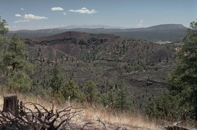
About Carrizozo
Carrizozo is a pyroclastic cone(s) rising to 1,731 meters (5,679 feet) in United States's North America Volcanic Regions. The volcano is currently active, with its most recent eruption in 3250 BCE. The volcano has produced 1 recorded eruption.
Geography & Climate
Carrizozo is located in United States, within the Basin and Range Volcanic Province of the broader North America Volcanic Regions. Situated at 33.78° N, 105.93° W in the Northern Hemisphere, the volcano lies within a subtropical climate zone. With a summit elevation of 1,731 meters above sea level, Carrizozo is a moderately sized peak that remains accessible to hikers and researchers for much of the year. The volcanic landform is characterized as a minor, which describes the physical shape and structure of the volcanic edifice as observed from the surface.
Geological Context
Carrizozo is situated along a rift zone, where tectonic plates are pulling apart. As the crust thins and fractures, magma rises to fill the gap, creating volcanic activity. Rift volcanism typically produces more fluid lava flows rather than explosive blasts, which means communities near Carrizozo in United States generally face slower-moving hazards like lava flows and ground fissures rather than sudden pyroclastic events. However, rift volcanoes can still generate significant ash emissions and gas releases that affect local air quality. The dominant rock type is basalt / picro-basalt, a dark, fine-grained volcanic rock that forms from rapidly cooling, low-viscosity lava. Basaltic eruptions tend to be less explosive and produce fluid lava flows that can travel long distances. While less immediately dangerous than explosive eruptions, basaltic lava flows can destroy structures and infrastructure in their path, and volcanic gases released during these eruptions can affect air quality over a wide area.
Eruption History Summary
Carrizozo has 1 recorded eruption in the geological database, spanning from 3250 BCE to 3250 BCE.
GVP Reference Summary
The massive Carrizozo lava flow, which traveled 75 km down the Tularosa Basin of south-central New Mexico, is one of Earth's longest known Holocene lava flows. The youthful-looking flow originated from a broad low basaltic shield on the floor of the Tularosa Basin, east of the Rio Grande Rift, topped by Little Black Peak, a small cinder cone. The 4.2 km3 tube-fed pahoehoe flow covered 330 km2 and has a width that ranges from 1 km in the central neck region to 5 km in the proximal and distal portions. The flow was inferred to have been emplaced during a single long-duration eruption estimated to have lasted 2-3 decades. A surface exposure age of about 5,200 BP was obtained for the Carrizozo flow. An older lava flow traveled 16 km S and 11 km E from Broken Back crater.
— Smithsonian Institution, Global Volcanism Program
1 Recorded Eruption
| Year | VEI | Type | Area |
|---|---|---|---|
| 3250 BCE | — | Confirmed Eruption | Little Black Peak |
Real-Time Data
Frequently Asked Questions About Carrizozo
Is Carrizozo an active volcano?+
Carrizozo is not currently classified as active. Its activity evidence is listed as "Eruption Dated." The last known eruption was in 3250 BCE. However, no volcano is ever considered permanently extinct.
When did Carrizozo last erupt?+
The most recent recorded eruption of Carrizozo occurred in 3250 BCE. The eruption was classified as a "Confirmed Eruption." Carrizozo has 1 recorded eruption in total.
How high is Carrizozo?+
Carrizozo has a summit elevation of 1,731 meters (5,679 feet) above sea level. At 1,731 meters, it is a moderately sized volcanic peak, roughly comparable to Mount Vesuvius (1,281m).
What type of volcano is Carrizozo?+
Carrizozo is classified as a Pyroclastic cone(s). Pyroclastic cones (or cinder cones) are small, steep-sided volcanic cones built from fragments of lava blasted into the air. They are the simplest type of volcano and often form in groups.
Where is Carrizozo located?+
Carrizozo is located in United States, in the North America Volcanic Regions. More specifically, it lies within the Basin and Range Volcanic Province. Its exact coordinates are 33.780° latitude, -105.930° longitude.
Is it safe to visit Carrizozo?+
Carrizozo can generally be visited, but as with any volcano, visitors should check local conditions and any advisory notices before traveling. United States may have specific regulations for accessing volcanic areas. Guided tours are often the safest and most informative way to experience a volcano.