Golden Trout Creek
Volcanic field · 2,886m · United States
About Golden Trout Creek
Golden Trout Creek is a volcanic field rising to 2,886 meters (9,469 feet) in United States's North America Volcanic Regions. No historical eruptions have been recorded, though the volcano is classified based on geological evidence of past activity. The volcano has produced 1 recorded eruption, with a maximum Volcanic Explosivity Index (VEI) of 1.
Geography & Climate
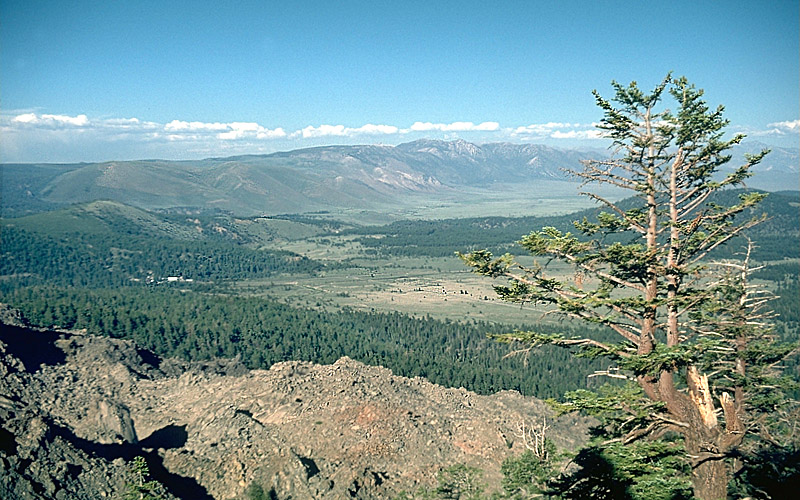
Golden Trout Creek is located in United States, within the Basin and Range Volcanic Province of the broader North America Volcanic Regions. Situated at 36.36° N, 118.32° W in the Northern Hemisphere, the volcano lies within a temperate climate zone. At 2,886 meters above sea level, Golden Trout Creek rises above the surrounding terrain into montane or subalpine conditions. The elevation creates distinct ecological zones along its flanks, from forested lower slopes to exposed rocky terrain near the summit. The volcanic landform is characterized as a cluster, which describes the physical shape and structure of the volcanic edifice as observed from the surface.
Eruption History Summary
Golden Trout Creek has 1 recorded eruption in the geological database, spanning from 55500 BCE to 55500 BCE. The most powerful recorded event was a gentle, effusive event in 55500 BCE, reaching VEI 1 on the Volcanic Explosivity Index.
GVP Reference Summary
The Golden Trout Creek volcanic field consists of a group of Quaternary alkali olivine basalt cinder cones and lava flows in the Toowa Valley about 25 km S of Mount Whitney. Lava flows erupted through Mesozoic granitic rocks of the Sierra Nevada batholith during episodes dating back to about 743,000 years ago, when the Little Whitney cinder cone and lava flows were erupted. The South Fork cone erupted about 176,000 years ago and produced the largest lava flow in the field, which traveled over 7 km W to the Kern River Canyon. Tunnel Cone to the north of South Fork (Red Hill) cone is undated, but its lava flow is overlain by glacial deposits and it is thought to be only slightly younger than South Fork. The youngest lava flow, from Groundhog Cone, traveled 6 km W down Golden Trout Creek on top of the South Fork flow. Based on a lack of glaciated features, Moore and Lanphere (1983) considered the Groundhog flow to be about 5-10,000 years old. Cosmogenic 36Cl exposure determinations by Browne et al. (2017b) showed a 59-52 ka eruption age for the Groundhog Cone material; this was after the Tahoe glaciation maximum, and subsequent Tioga glaciers did not reach the Toowa Valley floor, so did not affect these deposits.
— Smithsonian Institution, Global Volcanism Program
1 Recorded Eruption
| Year | VEI | Type | Area |
|---|---|---|---|
| 55500 BCE | 1 | Confirmed Eruption | Groundhog Crater |
Real-Time Data
Frequently Asked Questions About Golden Trout Creek
Is Golden Trout Creek an active volcano?+
Golden Trout Creek is not currently classified as active. Its activity evidence is listed as "unknown." No recorded eruptions have been documented. However, no volcano is ever considered permanently extinct.
When did Golden Trout Creek last erupt?+
The most recent recorded eruption of Golden Trout Creek occurred in 55500 BCE with a Volcanic Explosivity Index (VEI) of 1. The eruption was classified as a "Confirmed Eruption." Golden Trout Creek has 1 recorded eruption in total.
How high is Golden Trout Creek?+
Golden Trout Creek has a summit elevation of 2,886 meters (9,469 feet) above sea level. At 2,886 meters, it is comparable in height to many significant mountain peaks and stands well above the tree line.
What type of volcano is Golden Trout Creek?+
Golden Trout Creek is classified as a Volcanic field. Volcanic fields consist of clusters of small volcanic vents and cinder cones spread across a region. Rather than a single central vent, eruptions can occur at many points across the field.
Where is Golden Trout Creek located?+
Golden Trout Creek is located in United States, in the North America Volcanic Regions. More specifically, it lies within the Basin and Range Volcanic Province. Its exact coordinates are 36.358° latitude, -118.320° longitude.
Is it safe to visit Golden Trout Creek?+
Golden Trout Creek can generally be visited, but as with any volcano, visitors should check local conditions and any advisory notices before traveling. United States may have specific regulations for accessing volcanic areas. Guided tours are often the safest and most informative way to experience a volcano.