About Long Valley
Long Valley is a caldera rising to 3,390 meters (11,123 feet) in United States's North America Volcanic Regions. No historical eruptions have been recorded, though the volcano is classified based on geological evidence of past activity.
Geography & Climate
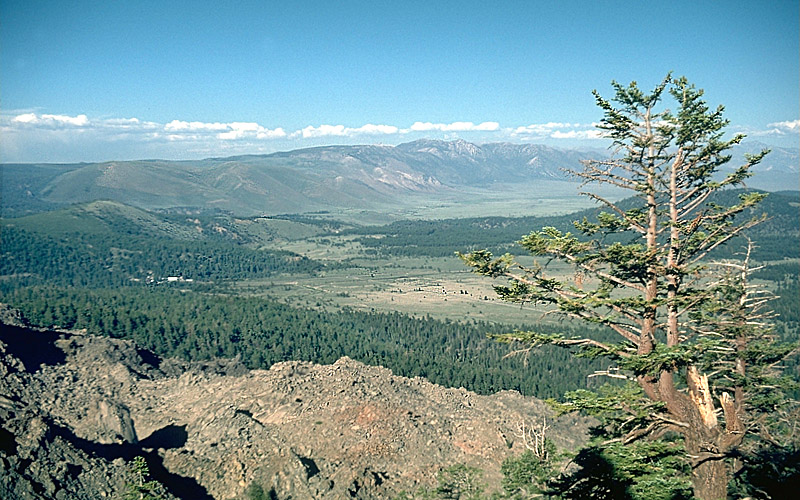
Long Valley is located in United States, within the Basin and Range Volcanic Province of the broader North America Volcanic Regions. Situated at 37.70° N, 118.87° W in the Northern Hemisphere, the volcano lies within a temperate climate zone. At 3,390 meters above sea level, Long Valley rises above the surrounding terrain into montane or subalpine conditions. The elevation creates distinct ecological zones along its flanks, from forested lower slopes to exposed rocky terrain near the summit. The volcanic landform is characterized as a caldera, which describes the physical shape and structure of the volcanic edifice as observed from the surface.
GVP Reference Summary
The large 17 x 32 km Long Valley caldera east of the central Sierra Nevada Range formed as a result of the voluminous Bishop Tuff eruption about 760,000 years ago. Resurgent doming in the central part of the caldera occurred shortly afterwards, followed by rhyolitic eruptions from the caldera moat and the eruption of rhyodacite from outer ring fracture vents, ending about 50,000 years ago. During early resurgent doming the caldera was filled with a large lake that left strandlines on the caldera walls and the resurgent dome island; the lake eventually drained through the Owens River Gorge. The caldera remains thermally active, with many hot springs and fumaroles, and has had significant deformation, seismicity, and other unrest in recent years. The late-Pleistocene to Holocene Inyo Craters cut the NW topographic rim of the caldera, and along with Mammoth Mountain on the SW topographic rim, are west of the structural caldera and are chemically and tectonically distinct from the Long Valley magmatic system.
— Smithsonian Institution, Global Volcanism Program
0 Recorded Eruptions
No eruption records available for Long Valley.
Real-Time Data
Frequently Asked Questions About Long Valley
Is Long Valley an active volcano?+
Long Valley is not currently classified as active. Its activity evidence is listed as "unknown." No recorded eruptions have been documented. However, no volcano is ever considered permanently extinct.
How high is Long Valley?+
Long Valley has a summit elevation of 3,390 meters (11,123 feet) above sea level. At 3,390 meters, it is comparable in height to many significant mountain peaks and stands well above the tree line.
What type of volcano is Long Valley?+
Long Valley is classified as a Caldera. Calderas are large volcanic depressions formed when a volcano erupts so powerfully that its magma chamber collapses, creating a basin that can be kilometers wide. They are often sites of some of Earth's largest eruptions.
Where is Long Valley located?+
Long Valley is located in United States, in the North America Volcanic Regions. More specifically, it lies within the Basin and Range Volcanic Province. Its exact coordinates are 37.700° latitude, -118.870° longitude.
Is it safe to visit Long Valley?+
Long Valley can generally be visited, but as with any volcano, visitors should check local conditions and any advisory notices before traveling. United States may have specific regulations for accessing volcanic areas. Guided tours are often the safest and most informative way to experience a volcano.
