Mono Lake Volcanic Field
Volcanic field · 2,121m · United States
About Mono Lake Volcanic Field
Mono Lake Volcanic Field is a volcanic field rising to 2,121 meters (6,959 feet) in United States's North America Volcanic Regions. Its last known eruption was in 1790 CE. The volcano has produced 5 recorded eruptions.
Geography & Climate
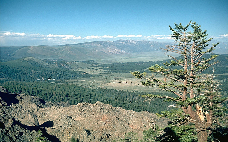
Mono Lake Volcanic Field is located in United States, within the Basin and Range Volcanic Province of the broader North America Volcanic Regions. Situated at 38.00° N, 119.03° W in the Northern Hemisphere, the volcano lies within a temperate climate zone. At 2,121 meters above sea level, Mono Lake Volcanic Field rises above the surrounding terrain into montane or subalpine conditions. The elevation creates distinct ecological zones along its flanks, from forested lower slopes to exposed rocky terrain near the summit. The volcanic landform is characterized as a cluster, which describes the physical shape and structure of the volcanic edifice as observed from the surface.
Geological Context
Mono Lake Volcanic Field is situated along a rift zone, where tectonic plates are pulling apart. As the crust thins and fractures, magma rises to fill the gap, creating volcanic activity. Rift volcanism typically produces more fluid lava flows rather than explosive blasts, which means communities near Mono Lake Volcanic Field in United States generally face slower-moving hazards like lava flows and ground fissures rather than sudden pyroclastic events. However, rift volcanoes can still generate significant ash emissions and gas releases that affect local air quality. The dominant rock type is dacite, an intermediate to silica-rich volcanic rock. This composition typically produces more viscous magma, leading to more explosive eruptions with ash columns and pyroclastic flows. Andesitic and dacitic magmas build pressure before erupting, which is why volcanoes with this rock chemistry are often associated with Plinian-style eruptions that can send ash tens of kilometers into the atmosphere and disrupt aviation across entire regions.
Eruption History Summary
Mono Lake Volcanic Field has 5 recorded eruptions in the geological database, spanning from 350 CE to 1890 CE. This eruption frequency indicates a moderately active volcanic system with periodic reawakenings.
Significance
With 5 recorded eruptions on file, Mono Lake Volcanic Field has enough documented activity to help scientists identify patterns in its eruptive behavior.
GVP Reference Summary
The Mono Lake volcanic field east of Yosemite National Park and north of the Mono Craters consists of vents within Mono Lake and on its north shore. The most topographically prominent feature, Black Point, is an initially sublacustral basaltic cone that rises above the NW shore and was formed about 13,300 years ago when Mono Lake was higher. Holocene rhyodacitic lava domes and flows form Negit and parts of Paoha islands off the northern shore and center of the lake, respectively. The most recent eruptive activity in the Long Valley to Mono Lake region took place 100-230 years ago, when lake-bottom sediments forming much of Paoha Island were uplifted by intrusion of a rhyolitic cryptodome (Stine, in Bailey et al., 1989). Spectacular tufa towers line the shores of Mono Lake.
— Smithsonian Institution, Global Volcanism Program
5 Recorded Eruptions
| Year | VEI | Type | Area |
|---|---|---|---|
| 1890 | — | Uncertain Eruption | — |
| 1790 | — | Confirmed Eruption | Paoha Island |
| 1550 | — | Confirmed Eruption | Negit Island |
| 1150 | — | Confirmed Eruption | Paoha Island |
| 350 | — | Confirmed Eruption | — |
Real-Time Data
Frequently Asked Questions About Mono Lake Volcanic Field
Is Mono Lake Volcanic Field an active volcano?+
Mono Lake Volcanic Field is not currently classified as active. Its activity evidence is listed as "Eruption Dated." The last known eruption was in 1790 CE. However, no volcano is ever considered permanently extinct.
When did Mono Lake Volcanic Field last erupt?+
The most recent recorded eruption of Mono Lake Volcanic Field occurred in 1890 CE. The eruption was classified as a "Uncertain Eruption." Mono Lake Volcanic Field has 5 recorded eruptions in total.
How high is Mono Lake Volcanic Field?+
Mono Lake Volcanic Field has a summit elevation of 2,121 meters (6,959 feet) above sea level. At 2,121 meters, it is comparable in height to many significant mountain peaks and stands well above the tree line.
What type of volcano is Mono Lake Volcanic Field?+
Mono Lake Volcanic Field is classified as a Volcanic field. Volcanic fields consist of clusters of small volcanic vents and cinder cones spread across a region. Rather than a single central vent, eruptions can occur at many points across the field.
Where is Mono Lake Volcanic Field located?+
Mono Lake Volcanic Field is located in United States, in the North America Volcanic Regions. More specifically, it lies within the Basin and Range Volcanic Province. Its exact coordinates are 38.000° latitude, -119.030° longitude.
Is it safe to visit Mono Lake Volcanic Field?+
Mono Lake Volcanic Field can generally be visited, but as with any volcano, visitors should check local conditions and any advisory notices before traveling. United States may have specific regulations for accessing volcanic areas. Guided tours are often the safest and most informative way to experience a volcano.