About Saddle Butte
Saddle Butte is a volcanic field rising to 1,700 meters (5,578 feet) in United States's North America Volcanic Regions. No historical eruptions have been recorded, though the volcano is classified based on geological evidence of past activity.
Geography & Climate
Saddle Butte is located in United States, within the High Lava Plains Volcanic Province of the broader North America Volcanic Regions. Situated at 43.00° N, 117.80° W in the Northern Hemisphere, the volcano lies within a temperate climate zone. With a summit elevation of 1,700 meters above sea level, Saddle Butte is a moderately sized peak that remains accessible to hikers and researchers for much of the year. The volcanic landform is characterized as a cluster, which describes the physical shape and structure of the volcanic edifice as observed from the surface.
GVP Reference Summary
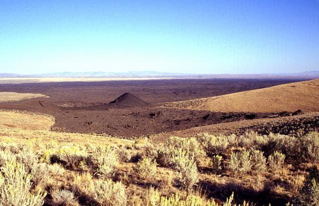
The Saddle Butte volcanic field in SE Oregon consists of a 1100 km2 area of Pleistocene basalts with a superposed 240 km2 area of younger basalts. The younger flows were considered to be of possible Holocene age (Wood and Kienle, 1990), however Sherrod et al. (1989) mapped the volcanic field as Pleistocene, and a K-Ar date of 0.43 +/-0.09 million years was obtained. Oregon state Highway 78 cuts across the western side of the isolated lava field. The volcanic field is separated from the adjacent Jordan Craters field to the east by the Owyhee River and resembles the lava fields of the Snake River Plain in Idaho. Vents on the flanks of the Sheepshead Mountains at the far western end of the lava field produced lava-tube-fed flows across gently sloping terrain to the east. The most recent flow of the Saddle Butte volcanic field is known for its abundant lava tubes, including the so-called 40-Mile Cave, which is actually part of a tube system that is 13.5 km long.
— Smithsonian Institution, Global Volcanism Program
0 Recorded Eruptions
No eruption records available for Saddle Butte.
Real-Time Data
Frequently Asked Questions About Saddle Butte
Is Saddle Butte an active volcano?+
Saddle Butte is not currently classified as active. Its activity evidence is listed as "unknown." No recorded eruptions have been documented. However, no volcano is ever considered permanently extinct.
How high is Saddle Butte?+
Saddle Butte has a summit elevation of 1,700 meters (5,578 feet) above sea level. At 1,700 meters, it is a moderately sized volcanic peak, roughly comparable to Mount Vesuvius (1,281m).
What type of volcano is Saddle Butte?+
Saddle Butte is classified as a Volcanic field. Volcanic fields consist of clusters of small volcanic vents and cinder cones spread across a region. Rather than a single central vent, eruptions can occur at many points across the field.
Where is Saddle Butte located?+
Saddle Butte is located in United States, in the North America Volcanic Regions. More specifically, it lies within the High Lava Plains Volcanic Province. Its exact coordinates are 43.000° latitude, -117.800° longitude.
Is it safe to visit Saddle Butte?+
Saddle Butte can generally be visited, but as with any volcano, visitors should check local conditions and any advisory notices before traveling. United States may have specific regulations for accessing volcanic areas. Guided tours are often the safest and most informative way to experience a volcano.