About Garibaldi Lake
Garibaldi Lake is a volcanic field rising to 2,316 meters (7,599 feet) in Canada's North America Volcanic Regions. No historical eruptions have been recorded, though the volcano is classified based on geological evidence of past activity.
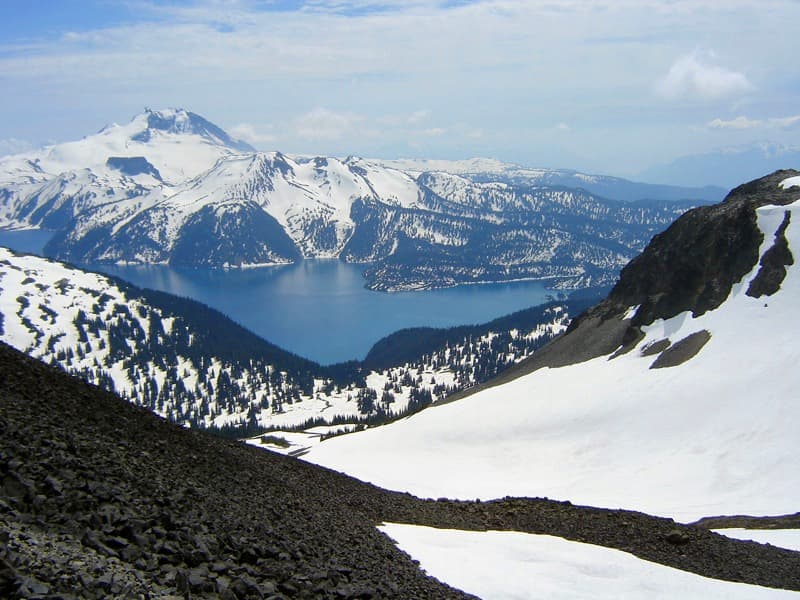
Geography & Climate
Garibaldi Lake is located in Canada, within the Garibaldi Volcanic Arc of the broader North America Volcanic Regions. Situated at 49.93° N, 123.00° W in the Northern Hemisphere, the volcano lies within a temperate climate zone. At 2,316 meters above sea level, Garibaldi Lake rises above the surrounding terrain into montane or subalpine conditions. The elevation creates distinct ecological zones along its flanks, from forested lower slopes to exposed rocky terrain near the summit. The volcanic landform is characterized as a cluster, which describes the physical shape and structure of the volcanic edifice as observed from the surface.
Geological Context
Garibaldi Lake sits in a subduction zone, where one tectonic plate dives beneath another, creating intense heat and pressure that generates magma. Subduction zones are responsible for many of the world's most explosive volcanoes and deadliest eruptions. For communities in Canada near Garibaldi Lake, this tectonic setting means the volcano is capable of producing powerful explosive eruptions, pyroclastic flows, and lahars that can threaten populated areas within tens of kilometers of the summit. The dominant rock type is andesite / basaltic andesite, a dark, fine-grained volcanic rock that forms from rapidly cooling, low-viscosity lava. Basaltic eruptions tend to be less explosive and produce fluid lava flows that can travel long distances. While less immediately dangerous than explosive eruptions, basaltic lava flows can destroy structures and infrastructure in their path, and volcanic gases released during these eruptions can affect air quality over a wide area.
GVP Reference Summary
A group of nine small andesitic stratovolcanoes and basaltic andesite vents in the scenic Garibaldi Lake area immediately north of Mount Garibaldi was formed during the late Pleistocene and early Holocene. The oldest stratovolcano, The Black Tusk, formed between about 1.3 and 1.1 million years ago (Ma). Following glacial dissection, renewed volcanism (0.21-0.17 Ma) produced the lava dome and flow forming its summit. Other Pleistocene vents are located along and to the west of the Cheakamus River. The Cinder Cone, to the east of The Black Tusk, produced a 9-km-long lava flow during the late Pleistocene or early Holocene (0.04 +/- 0.04 Ma). Mount Price, west of Garibaldi Lake, was formed in three stages dating back to 1.1 million years, the latest of which produced two large lava flows from Clinker Peak during the early Holocene that ponded against the retreating continental ice sheet and formed the barrier containing Garibaldi Lake. The Table, a steep-sided subglacial tuya south of Garibaldi Lake, was also formed during the early Holocene.
— Smithsonian Institution, Global Volcanism Program
0 Recorded Eruptions
No eruption records available for Garibaldi Lake.
Real-Time Data
Frequently Asked Questions About Garibaldi Lake
Is Garibaldi Lake an active volcano?+
Garibaldi Lake is classified as active based on credible evidence of past eruptions. Although its last known eruption was in prehistoric times, volcanologists consider it capable of erupting again.
How high is Garibaldi Lake?+
Garibaldi Lake has a summit elevation of 2,316 meters (7,599 feet) above sea level. At 2,316 meters, it is comparable in height to many significant mountain peaks and stands well above the tree line.
What type of volcano is Garibaldi Lake?+
Garibaldi Lake is classified as a Volcanic field. Volcanic fields consist of clusters of small volcanic vents and cinder cones spread across a region. Rather than a single central vent, eruptions can occur at many points across the field.
Where is Garibaldi Lake located?+
Garibaldi Lake is located in Canada, in the North America Volcanic Regions. More specifically, it lies within the Garibaldi Volcanic Arc. Its exact coordinates are 49.933° latitude, -123.000° longitude.
Is it safe to visit Garibaldi Lake?+
Garibaldi Lake can generally be visited, but as with any volcano, visitors should check local conditions and any advisory notices before traveling. Canada may have specific regulations for accessing volcanic areas. Guided tours are often the safest and most informative way to experience a volcano.

