About Vsevidof
Vsevidof is a stratovolcano rising to 2,160 meters (7,087 feet) in United States's North America Volcanic Regions. Its last known eruption was in 1878 CE. The volcano has produced 7 recorded eruptions, with a maximum Volcanic Explosivity Index (VEI) of 3.
Geography & Climate
Vsevidof is located in United States, within the Aleutian Ridge Volcanic Arc of the broader North America Volcanic Regions. Situated at 53.13° N, 168.69° W in the Northern Hemisphere, the volcano lies within a temperate climate zone. At 2,160 meters above sea level, Vsevidof rises above the surrounding terrain into montane or subalpine conditions. The elevation creates distinct ecological zones along its flanks, from forested lower slopes to exposed rocky terrain near the summit. The volcanic landform is characterized as a composite, which describes the physical shape and structure of the volcanic edifice as observed from the surface.
Geological Context
Vsevidof sits in a subduction zone, where one tectonic plate dives beneath another, creating intense heat and pressure that generates magma. Subduction zones are responsible for many of the world's most explosive volcanoes and deadliest eruptions. For communities in United States near Vsevidof, this tectonic setting means the volcano is capable of producing powerful explosive eruptions, pyroclastic flows, and lahars that can threaten populated areas within tens of kilometers of the summit. The dominant rock type is andesite / basaltic andesite, a dark, fine-grained volcanic rock that forms from rapidly cooling, low-viscosity lava. Basaltic eruptions tend to be less explosive and produce fluid lava flows that can travel long distances. While less immediately dangerous than explosive eruptions, basaltic lava flows can destroy structures and infrastructure in their path, and volcanic gases released during these eruptions can affect air quality over a wide area.
Eruption History Summary
Vsevidof has 7 recorded eruptions in the geological database, spanning from 1784 CE to 1957 CE. The most powerful recorded event was a severe eruption capable of regional ash fall and pyroclastic flows in 1817 CE, reaching VEI 3 on the Volcanic Explosivity Index. This eruption frequency indicates a moderately active volcanic system with periodic reawakenings. The most recent eruption in 1957 CE places this volcano within the modern era of volcanological observation.
Significance
With a maximum recorded VEI of 3, Vsevidof has produced eruptions capable of generating pyroclastic flows and significant ash fall in the surrounding area. While not among the largest eruptions globally, VEI 3 events pose serious hazards to local populations and can disrupt regional air travel. With 7 recorded eruptions on file, Vsevidof has enough documented activity to help scientists identify patterns in its eruptive behavior. Given its recent activity, Vsevidof is closely monitored by geological survey organizations to provide early warning of future unrest.
GVP Reference Summary
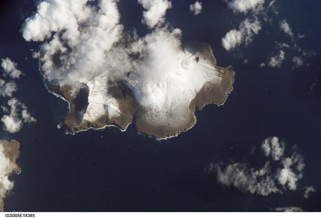
The symmetrical Vsevidof stratovolcano, near the SW end of Umnak Island, contains a 1.2-km-wide, ice-filled summit crater that is breached by glaciers on the E and N sides. An E-W-trending zone of scoria cones that extends down much of the W flank has been the source of recorded eruptions. Most of the cone was constructed during the Holocene. Andesitic and dacitic lava flows originated from vents on the N and S flanks, and on the W-flank rift. The largest lava flow traveled down the W flank to the coast, forming Cape Kigushimkada.
— Smithsonian Institution, Global Volcanism Program
7 Recorded Eruptions
| Year | VEI | Type | Area |
|---|---|---|---|
| 1957 | 2 | Uncertain Eruption | West flank fissure |
| 1880 | — | Uncertain Eruption | — |
| 1878 | 2 | Confirmed Eruption | West flank fissure ? |
| 1830 | — | Confirmed Eruption | SW end of Umnak Island |
| 1817 | 3 | Confirmed Eruption | — |
| 1790 | — | Uncertain Eruption | — |
| 1784 | — | Uncertain Eruption | — |
Real-Time Data
Frequently Asked Questions About Vsevidof
Is Vsevidof an active volcano?+
Vsevidof is classified as active based on credible evidence of past eruptions. Although its last known eruption was in 1878 CE, volcanologists consider it capable of erupting again.
When did Vsevidof last erupt?+
The most recent recorded eruption of Vsevidof occurred in 1957 CE with a Volcanic Explosivity Index (VEI) of 2. The eruption was classified as a "Uncertain Eruption." Vsevidof has 7 recorded eruptions in total.
How high is Vsevidof?+
Vsevidof has a summit elevation of 2,160 meters (7,087 feet) above sea level. At 2,160 meters, it is comparable in height to many significant mountain peaks and stands well above the tree line.
What type of volcano is Vsevidof?+
Vsevidof is classified as a Stratovolcano. Stratovolcanoes (also called composite volcanoes) are steep, conical volcanoes built up by many layers of hardened lava, tephra, and volcanic ash. They are among the most common and dangerous types, known for explosive eruptions.
Where is Vsevidof located?+
Vsevidof is located in United States, in the North America Volcanic Regions. More specifically, it lies within the Aleutian Ridge Volcanic Arc. Its exact coordinates are 53.126° latitude, -168.688° longitude.
Is it safe to visit Vsevidof?+
Vsevidof can generally be visited, but as with any volcano, visitors should check local conditions and any advisory notices before traveling. United States may have specific regulations for accessing volcanic areas. Guided tours are often the safest and most informative way to experience a volcano.