About Kagamil
Kagamil is a stratovolcano rising to 893 meters (2,930 feet) in United States's North America Volcanic Regions. It last erupted in 1929 CE, and volcanologists consider it an active volcanic system. The volcano has produced 1 recorded eruption.
Geography & Climate
Kagamil is located in United States, within the Aleutian Ridge Volcanic Arc of the broader North America Volcanic Regions. Situated at 52.97° N, 169.72° W in the Northern Hemisphere, the volcano lies within a temperate climate zone. With a summit elevation of 893 meters above sea level, Kagamil is a moderately sized peak that remains accessible to hikers and researchers for much of the year. The volcanic landform is characterized as a composite, which describes the physical shape and structure of the volcanic edifice as observed from the surface.
Geological Context
Kagamil sits in a subduction zone, where one tectonic plate dives beneath another, creating intense heat and pressure that generates magma. Subduction zones are responsible for many of the world's most explosive volcanoes and deadliest eruptions. For communities in United States near Kagamil, this tectonic setting means the volcano is capable of producing powerful explosive eruptions, pyroclastic flows, and lahars that can threaten populated areas within tens of kilometers of the summit. The dominant rock type is no data (checked), which influences the viscosity of the magma and, consequently, the style of eruptions this volcano produces. Rock chemistry is one of the most important factors in determining whether a volcano erupts explosively or effusively.
Eruption History Summary
Kagamil has 1 recorded eruption in the geological database, spanning from 1929 CE to 1929 CE. The most recent eruption in 1929 CE places this volcano within the modern era of volcanological observation.
GVP Reference Summary
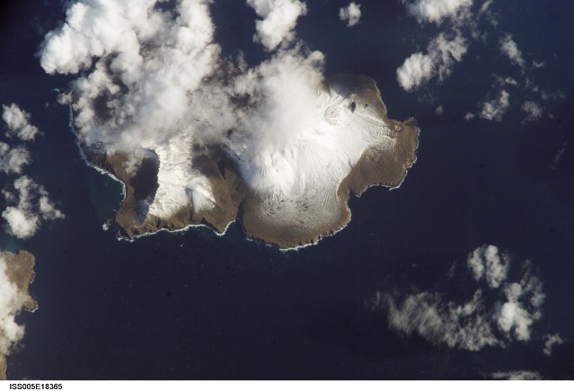
Kagamil Island lies near the NE end of the Islands of the Four Mountains archipelago in the central Aleutians, between Chuginadak and Uliaga Islands. The southern half of the 5 x 10 km island contains two undissected cones of postglacial age with small summit craters. The larger cone is located at the SE end of the NNW-SSE-trending volcano. Arcuate ridges at the northern and southern ends of the island suggest a possible earlier caldera. Hot springs and fumaroles occur along a steaming beach at the SE coast. The early explorer Veniaminof (1840) indicated that Kagamil formerly "flamed and smoked," but the only eruptive report is of unspecified activity in 1929 (Coats 1950).
— Smithsonian Institution, Global Volcanism Program
1 Recorded Eruption
| Year | VEI | Type | Area |
|---|---|---|---|
| 1929 | — | Confirmed Eruption | — |
Real-Time Data
Frequently Asked Questions About Kagamil
Is Kagamil an active volcano?+
Yes, Kagamil is considered an active volcano. Its most recent eruption was in 1929 CE. The volcano is monitored by geological agencies, and its activity status is based on observed eruptions within recorded history.
When did Kagamil last erupt?+
The most recent recorded eruption of Kagamil occurred in 1929 CE. The eruption was classified as a "Confirmed Eruption." Kagamil has 1 recorded eruption in total.
How high is Kagamil?+
Kagamil has a summit elevation of 893 meters (2,930 feet) above sea level. At 893 meters, it is a relatively low-elevation volcano.
What type of volcano is Kagamil?+
Kagamil is classified as a Stratovolcano. Stratovolcanoes (also called composite volcanoes) are steep, conical volcanoes built up by many layers of hardened lava, tephra, and volcanic ash. They are among the most common and dangerous types, known for explosive eruptions.
Where is Kagamil located?+
Kagamil is located in United States, in the North America Volcanic Regions. More specifically, it lies within the Aleutian Ridge Volcanic Arc. Its exact coordinates are 52.974° latitude, -169.720° longitude.
Is it safe to visit Kagamil?+
Visiting Kagamil requires checking current volcanic activity and alert levels. As an active volcano with eruptions as recent as 1929 CE, conditions can change rapidly. Always consult local geological authorities and follow official warnings before visiting. Many active volcanoes have designated safe viewing areas and guided tour options.


