About Carlisle
Carlisle is a stratovolcano rising to 1,620 meters (5,315 feet) in United States's North America Volcanic Regions. Its last known eruption was in 1828 CE. The volcano has produced 4 recorded eruptions.
Geography & Climate
Carlisle is located in United States, within the Aleutian Ridge Volcanic Arc of the broader North America Volcanic Regions. Situated at 52.89° N, 170.05° W in the Northern Hemisphere, the volcano lies within a temperate climate zone. With a summit elevation of 1,620 meters above sea level, Carlisle is a moderately sized peak that remains accessible to hikers and researchers for much of the year. The volcanic landform is characterized as a composite, which describes the physical shape and structure of the volcanic edifice as observed from the surface.
Geological Context
Carlisle sits in a subduction zone, where one tectonic plate dives beneath another, creating intense heat and pressure that generates magma. Subduction zones are responsible for many of the world's most explosive volcanoes and deadliest eruptions. For communities in United States near Carlisle, this tectonic setting means the volcano is capable of producing powerful explosive eruptions, pyroclastic flows, and lahars that can threaten populated areas within tens of kilometers of the summit. The dominant rock type is andesite / basaltic andesite, a dark, fine-grained volcanic rock that forms from rapidly cooling, low-viscosity lava. Basaltic eruptions tend to be less explosive and produce fluid lava flows that can travel long distances. While less immediately dangerous than explosive eruptions, basaltic lava flows can destroy structures and infrastructure in their path, and volcanic gases released during these eruptions can affect air quality over a wide area.
Eruption History Summary
Carlisle has 4 recorded eruptions in the geological database, spanning from 1774 CE to 1987 CE. These eruptions span roughly 213 years of volcanic history. The most recent eruption in 1987 CE places this volcano within the modern era of volcanological observation.
GVP Reference Summary
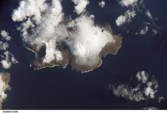
Carlisle Island is a steep-sided, conical stratovolcano across the Carlisle Pass strait from Mount Cleveland. Radar images suggest that this uninhabited, 7-km-wide island may contain two closely spaced volcanic cones (Myers, in Wood and Kienle 1990). Like nearby Herbert volcano, no geologic studies have been conducted on the volcano. Eruptions have been reported since the 18th century, but are very poorly documented. A variety of names was attached to Carlisle on early hydrographic maps, and Miller et al. (1998) noted that some 18th and 19th century eruptions reported at the closely spaced volcanoes of the "Islands of the Four Mountains" area could refer to Carlisle as well as Cleveland, Uliaga, or Kagamil volcanoes.
— Smithsonian Institution, Global Volcanism Program
4 Recorded Eruptions
| Year | VEI | Type | Area |
|---|---|---|---|
| 1987 | — | Uncertain Eruption | — |
| 1838 | — | Uncertain Eruption | — |
| 1828 | — | Confirmed Eruption | — |
| 1774 | — | Confirmed Eruption | — |
Real-Time Data
Frequently Asked Questions About Carlisle
Is Carlisle an active volcano?+
Carlisle is classified as active based on credible evidence of past eruptions. Although its last known eruption was in 1828 CE, volcanologists consider it capable of erupting again.
When did Carlisle last erupt?+
The most recent recorded eruption of Carlisle occurred in 1987 CE. The eruption was classified as a "Uncertain Eruption." Carlisle has 4 recorded eruptions in total.
How high is Carlisle?+
Carlisle has a summit elevation of 1,620 meters (5,315 feet) above sea level. At 1,620 meters, it is a moderately sized volcanic peak, roughly comparable to Mount Vesuvius (1,281m).
What type of volcano is Carlisle?+
Carlisle is classified as a Stratovolcano. Stratovolcanoes (also called composite volcanoes) are steep, conical volcanoes built up by many layers of hardened lava, tephra, and volcanic ash. They are among the most common and dangerous types, known for explosive eruptions.
Where is Carlisle located?+
Carlisle is located in United States, in the North America Volcanic Regions. More specifically, it lies within the Aleutian Ridge Volcanic Arc. Its exact coordinates are 52.894° latitude, -170.054° longitude.
Is it safe to visit Carlisle?+
Carlisle can generally be visited, but as with any volcano, visitors should check local conditions and any advisory notices before traveling. United States may have specific regulations for accessing volcanic areas. Guided tours are often the safest and most informative way to experience a volcano.