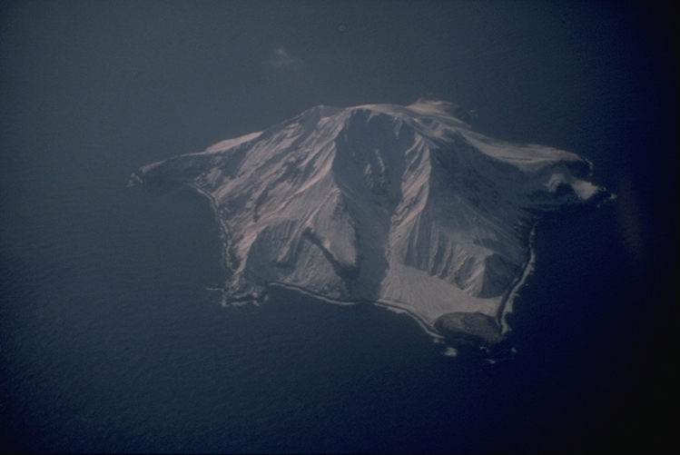
About Takawangha
Takawangha is a stratovolcano rising to 1,449 meters (4,754 feet) in United States's North America Volcanic Regions. Its last known eruption was in 1550 CE. The volcano has produced 1 recorded eruption.
Geography & Climate
Takawangha is located in United States, within the Aleutian Ridge Volcanic Arc of the broader North America Volcanic Regions. Situated at 51.87° N, 178.01° W in the Northern Hemisphere, the volcano lies within a temperate climate zone. With a summit elevation of 1,449 meters above sea level, Takawangha is a moderately sized peak that remains accessible to hikers and researchers for much of the year. The volcanic landform is characterized as a composite, which describes the physical shape and structure of the volcanic edifice as observed from the surface.
Geological Context
Takawangha sits in a subduction zone, where one tectonic plate dives beneath another, creating intense heat and pressure that generates magma. Subduction zones are responsible for many of the world's most explosive volcanoes and deadliest eruptions. For communities in United States near Takawangha, this tectonic setting means the volcano is capable of producing powerful explosive eruptions, pyroclastic flows, and lahars that can threaten populated areas within tens of kilometers of the summit. The dominant rock type is basalt / picro-basalt, a dark, fine-grained volcanic rock that forms from rapidly cooling, low-viscosity lava. Basaltic eruptions tend to be less explosive and produce fluid lava flows that can travel long distances. While less immediately dangerous than explosive eruptions, basaltic lava flows can destroy structures and infrastructure in their path, and volcanic gases released during these eruptions can affect air quality over a wide area.
Eruption History Summary
Takawangha has 1 recorded eruption in the geological database, spanning from 1550 CE to 1550 CE.
GVP Reference Summary
Takawangha is a youthful volcano with an ice-filled caldera on northern Tanaga Island, near the western end of the Andreanof Islands. It lies across a saddle from historically active Tanaga volcano to the west; older, deeply eroded volcanoes lie adjacent to the east. The summit of the dominantly basaltic to basaltic andesite volcano is largely ice covered, with the exception of five Holocene craters that during the last few thousand years produced explosive eruptions and lava flows that reached the lower flanks. No historical eruptions are known, although radiocarbon dating indicates explosive eruptions have occurred within the past several hundred years.
— Smithsonian Institution, Global Volcanism Program
1 Recorded Eruption
| Year | VEI | Type | Area |
|---|---|---|---|
| 1550 | — | Confirmed Eruption | — |
Real-Time Data
Frequently Asked Questions About Takawangha
Is Takawangha an active volcano?+
Takawangha is not currently classified as active. Its activity evidence is listed as "Eruption Dated." The last known eruption was in 1550 CE. However, no volcano is ever considered permanently extinct.
When did Takawangha last erupt?+
The most recent recorded eruption of Takawangha occurred in 1550 CE. The eruption was classified as a "Confirmed Eruption." Takawangha has 1 recorded eruption in total.
How high is Takawangha?+
Takawangha has a summit elevation of 1,449 meters (4,754 feet) above sea level. At 1,449 meters, it is a moderately sized volcanic peak, roughly comparable to Mount Vesuvius (1,281m).
What type of volcano is Takawangha?+
Takawangha is classified as a Stratovolcano. Stratovolcanoes (also called composite volcanoes) are steep, conical volcanoes built up by many layers of hardened lava, tephra, and volcanic ash. They are among the most common and dangerous types, known for explosive eruptions.
Where is Takawangha located?+
Takawangha is located in United States, in the North America Volcanic Regions. More specifically, it lies within the Aleutian Ridge Volcanic Arc. Its exact coordinates are 51.873° latitude, -178.006° longitude.
Is it safe to visit Takawangha?+
Takawangha can generally be visited, but as with any volcano, visitors should check local conditions and any advisory notices before traveling. United States may have specific regulations for accessing volcanic areas. Guided tours are often the safest and most informative way to experience a volcano.