About Gareloi
Gareloi is a stratovolcano rising to 1,573 meters (5,161 feet) in United States's North America Volcanic Regions. It last erupted in 1989 CE, and volcanologists consider it an active volcanic system. The volcano has produced 16 recorded eruptions, with a maximum Volcanic Explosivity Index (VEI) of 3.
Geography & Climate
Gareloi is located in United States, within the Aleutian Ridge Volcanic Arc of the broader North America Volcanic Regions. Situated at 51.79° N, 178.79° W in the Northern Hemisphere, the volcano lies within a temperate climate zone. With a summit elevation of 1,573 meters above sea level, Gareloi is a moderately sized peak that remains accessible to hikers and researchers for much of the year. The volcanic landform is characterized as a composite, which describes the physical shape and structure of the volcanic edifice as observed from the surface.
Geological Context
Gareloi sits in a subduction zone, where one tectonic plate dives beneath another, creating intense heat and pressure that generates magma. Subduction zones are responsible for many of the world's most explosive volcanoes and deadliest eruptions. For communities in United States near Gareloi, this tectonic setting means the volcano is capable of producing powerful explosive eruptions, pyroclastic flows, and lahars that can threaten populated areas within tens of kilometers of the summit. The dominant rock type is basalt / picro-basalt, a dark, fine-grained volcanic rock that forms from rapidly cooling, low-viscosity lava. Basaltic eruptions tend to be less explosive and produce fluid lava flows that can travel long distances. While less immediately dangerous than explosive eruptions, basaltic lava flows can destroy structures and infrastructure in their path, and volcanic gases released during these eruptions can affect air quality over a wide area.
Eruption History Summary
Gareloi has 16 recorded eruptions in the geological database, spanning from 1760 CE to 1996 CE. The most powerful recorded event was a severe eruption capable of regional ash fall and pyroclastic flows in 1982 CE, reaching VEI 3 on the Volcanic Explosivity Index. Notable eruptions include 1982 CE (VEI 3), 1980 CE (VEI 3), 1929 CE (VEI 3). This level of eruptive frequency indicates a persistently active volcanic system that warrants ongoing monitoring. The most recent eruption in 1996 CE places this volcano within the modern era of volcanological observation.
Significance
With a maximum recorded VEI of 3, Gareloi has produced eruptions capable of generating pyroclastic flows and significant ash fall in the surrounding area. While not among the largest eruptions globally, VEI 3 events pose serious hazards to local populations and can disrupt regional air travel. With 16 recorded eruptions, Gareloi has a substantial eruptive history that provides valuable data for understanding volcanic behavior and assessing future hazards in the North America Volcanic Regions region. Given its recent activity, Gareloi is closely monitored by geological survey organizations to provide early warning of future unrest.
GVP Reference Summary
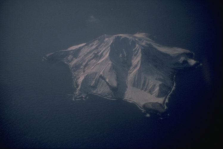
The 8 x 10 km Gareloi Island, the northernmost volcano of the Delarof Group at the western end of the Andreanof Islands, consists of a stratovolcano with two summits and a prominent SE-trending fissure. The fissure was formed during an eruption in 1929 and extends from the southern summit to the sea. Steep sea cliffs that are cut into rocks of an older, eroded center are found on the SW coast, and submarine deposits of three debris avalanches produced by edifice collapse are found offshore. Young lava flows cover the older volcano from the summit to the coast along three broad axes trending NW, ENE, and S. The 1929 eruption originated from 13 craters along a 4-km-long fissure. Phreatic explosions were followed by the ejection of glassy pumice, lapilli, scoria, and older blocks, as well as by the emission of four short, steep lava flows, one of which reached the SE coast.
— Smithsonian Institution, Global Volcanism Program
16 Recorded Eruptions
| Year | VEI | Type | Area |
|---|---|---|---|
| 1996 | 1 | Uncertain Eruption | — |
| 1989 | 1 | Confirmed Eruption | — |
| 1987 | 1 | Confirmed Eruption | N crater rim, E flank |
| 1982 | 3 | Confirmed Eruption | — |
| 1980 | 3 | Confirmed Eruption | — |
| 1952 | 2 | Confirmed Eruption | — |
| 1950 | 1 | Confirmed Eruption | — |
| 1929 | 3 | Confirmed Eruption | SE flank fissure (near summit to sea) |
| 1927 | — | Uncertain Eruption | — |
| 1922 | 3 | Confirmed Eruption | — |
| 1873 | 2 | Confirmed Eruption | — |
| 1828 | 2 | Uncertain Eruption | — |
| 1792 | 2 | Confirmed Eruption | — |
| 1791 | 2 | Confirmed Eruption | — |
| 1790 | 2 | Confirmed Eruption | — |
| 1760 | — | Uncertain Eruption | — |
Real-Time Data
Frequently Asked Questions About Gareloi
Is Gareloi an active volcano?+
Yes, Gareloi is considered an active volcano. Its most recent eruption was in 1989 CE. The volcano is monitored by geological agencies, and its activity status is based on observed eruptions within recorded history.
When did Gareloi last erupt?+
The most recent recorded eruption of Gareloi occurred in 1996 CE with a Volcanic Explosivity Index (VEI) of 1. The eruption was classified as a "Uncertain Eruption." Gareloi has 16 recorded eruptions in total.
How high is Gareloi?+
Gareloi has a summit elevation of 1,573 meters (5,161 feet) above sea level. At 1,573 meters, it is a moderately sized volcanic peak, roughly comparable to Mount Vesuvius (1,281m).
What type of volcano is Gareloi?+
Gareloi is classified as a Stratovolcano. Stratovolcanoes (also called composite volcanoes) are steep, conical volcanoes built up by many layers of hardened lava, tephra, and volcanic ash. They are among the most common and dangerous types, known for explosive eruptions.
Where is Gareloi located?+
Gareloi is located in United States, in the North America Volcanic Regions. More specifically, it lies within the Aleutian Ridge Volcanic Arc. Its exact coordinates are 51.790° latitude, -178.794° longitude.
Is it safe to visit Gareloi?+
Visiting Gareloi requires checking current volcanic activity and alert levels. As an active volcano with eruptions as recent as 1989 CE, conditions can change rapidly. Always consult local geological authorities and follow official warnings before visiting. Many active volcanoes have designated safe viewing areas and guided tour options.