About Khangar
Khangar is a stratovolcano rising to 1,967 meters (6,454 feet) in Russia's Northwestern Pacific Volcanic Regions. Its last known eruption was in 1500 CE. The volcano has produced 10 recorded eruptions, with a maximum Volcanic Explosivity Index (VEI) of 6.
Geography & Climate
Khangar is located in Russia, within the Central Kamchatka Volcanic Arc of the broader Northwestern Pacific Volcanic Regions. Situated at 54.76° N, 157.41° E in the Northern Hemisphere, the volcano lies within a temperate climate zone. With a summit elevation of 1,967 meters above sea level, Khangar is a moderately sized peak that remains accessible to hikers and researchers for much of the year. The volcanic landform is characterized as a composite, which describes the physical shape and structure of the volcanic edifice as observed from the surface.
Geological Context
Khangar sits in a subduction zone, where one tectonic plate dives beneath another, creating intense heat and pressure that generates magma. Subduction zones are responsible for many of the world's most explosive volcanoes and deadliest eruptions. For communities in Russia near Khangar, this tectonic setting means the volcano is capable of producing powerful explosive eruptions, pyroclastic flows, and lahars that can threaten populated areas within tens of kilometers of the summit. The dominant rock type is dacite, an intermediate to silica-rich volcanic rock. This composition typically produces more viscous magma, leading to more explosive eruptions with ash columns and pyroclastic flows. Andesitic and dacitic magmas build pressure before erupting, which is why volcanoes with this rock chemistry are often associated with Plinian-style eruptions that can send ash tens of kilometers into the atmosphere and disrupt aviation across entire regions.
Eruption History Summary
Khangar has 10 recorded eruptions in the geological database, spanning from 9500 BCE to 1500 CE. The most powerful recorded event was a colossal eruption capable of affecting global climate for years in 5700 BCE, reaching VEI 6 on the Volcanic Explosivity Index. Notable eruptions include 5700 BCE (VEI 6), 9500 BCE (VEI 4). This level of eruptive frequency indicates a persistently active volcanic system that warrants ongoing monitoring.
Significance
Khangar has produced at least one eruption of VEI 6 or higher, placing it among the most powerful volcanic systems on Earth. Eruptions of this magnitude inject massive quantities of sulfur dioxide into the stratosphere, affecting global climate by lowering average temperatures for one to three years after the event. With 10 recorded eruptions, Khangar has a substantial eruptive history that provides valuable data for understanding volcanic behavior and assessing future hazards in the Northwestern Pacific Volcanic Regions region.
GVP Reference Summary
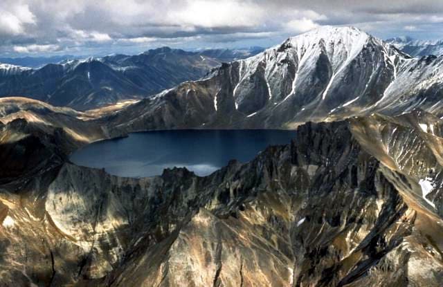
Khangar volcano, also spelled Hangar, is the southernmost volcano of the Sredinny Range, which stretches N-S across western Kamchaktka. It is the dominant feature within a larger volcano-tectonic depression composed of two parts: a stratovolcano with a 2-km-wide Holocene caldera, and a large lava dome on its eastern flank. The steep-walled caldera, now filled by a lake, was formed during a major explosive eruption about 7,000 years ago. An arcuate zone of pre-caldera flank lava domes nearly surrounds the volcano, and post-caldera domes form islands in the caldera lake. Late-stage olivine basalts were erupted along a NE-trending line in the southern part of the depression. The latest dated eruption took place about 500 years ago.
— Smithsonian Institution, Global Volcanism Program
10 Recorded Eruptions
| Year | VEI | Type | Area |
|---|---|---|---|
| 1500 | — | Confirmed Eruption | — |
| 1000 | — | Confirmed Eruption | — |
| 350 BCE | — | Confirmed Eruption | — |
| 2700 BCE | — | Confirmed Eruption | — |
| 5500 BCE | — | Confirmed Eruption | — |
| 5700 BCE | 6 | Confirmed Eruption | — |
| 6400 BCE | — | Confirmed Eruption | — |
| 7100 BCE | — | Confirmed Eruption | — |
| 8250 BCE | — | Confirmed Eruption | — |
| 9500 BCE | 4 | Confirmed Eruption | — |
Real-Time Data
Frequently Asked Questions About Khangar
Is Khangar an active volcano?+
Khangar is not currently classified as active. Its activity evidence is listed as "Eruption Dated." The last known eruption was in 1500 CE. However, no volcano is ever considered permanently extinct.
When did Khangar last erupt?+
The most recent recorded eruption of Khangar occurred in 1500 CE. The eruption was classified as a "Confirmed Eruption." Khangar has 10 recorded eruptions in total.
How high is Khangar?+
Khangar has a summit elevation of 1,967 meters (6,454 feet) above sea level. At 1,967 meters, it is a moderately sized volcanic peak, roughly comparable to Mount Vesuvius (1,281m).
What type of volcano is Khangar?+
Khangar is classified as a Stratovolcano. Stratovolcanoes (also called composite volcanoes) are steep, conical volcanoes built up by many layers of hardened lava, tephra, and volcanic ash. They are among the most common and dangerous types, known for explosive eruptions.
Where is Khangar located?+
Khangar is located in Russia, in the Northwestern Pacific Volcanic Regions. More specifically, it lies within the Central Kamchatka Volcanic Arc. Its exact coordinates are 54.761° latitude, 157.407° longitude.
Is it safe to visit Khangar?+
Khangar can generally be visited, but as with any volcano, visitors should check local conditions and any advisory notices before traveling. Russia may have specific regulations for accessing volcanic areas. Guided tours are often the safest and most informative way to experience a volcano.

