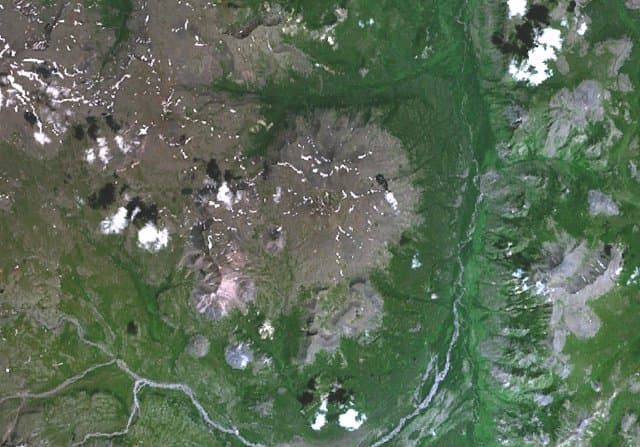
About Ichinsky
Ichinsky is a stratovolcano rising to 3,596 meters (11,798 feet) in Russia's Northwestern Pacific Volcanic Regions. Its last known eruption was in 1740 CE. The volcano has produced 14 recorded eruptions, with a maximum Volcanic Explosivity Index (VEI) of 5.
Geography & Climate
Ichinsky is located in Russia, within the Central Kamchatka Volcanic Arc of the broader Northwestern Pacific Volcanic Regions. Situated at 55.68° N, 157.72° E in the Northern Hemisphere, the volcano lies within a subarctic climate zone. Standing at 3,596 meters above sea level, Ichinsky towers above the alpine zone, where vegetation gives way to bare rock, snow, and ice for much of the year. The high elevation means the upper slopes experience significantly colder temperatures than surrounding lowlands. The volcanic landform is characterized as a composite, which describes the physical shape and structure of the volcanic edifice as observed from the surface.
Geological Context
Ichinsky sits in a subduction zone, where one tectonic plate dives beneath another, creating intense heat and pressure that generates magma. Subduction zones are responsible for many of the world's most explosive volcanoes and deadliest eruptions. For communities in Russia near Ichinsky, this tectonic setting means the volcano is capable of producing powerful explosive eruptions, pyroclastic flows, and lahars that can threaten populated areas within tens of kilometers of the summit. The dominant rock type is basalt / picro-basalt, a dark, fine-grained volcanic rock that forms from rapidly cooling, low-viscosity lava. Basaltic eruptions tend to be less explosive and produce fluid lava flows that can travel long distances. While less immediately dangerous than explosive eruptions, basaltic lava flows can destroy structures and infrastructure in their path, and volcanic gases released during these eruptions can affect air quality over a wide area.
Eruption History Summary
Ichinsky has 14 recorded eruptions in the geological database, spanning from 6950 BCE to 1740 CE. The most powerful recorded event was a paroxysmal eruption with devastating regional consequences in 5400 BCE, reaching VEI 5 on the Volcanic Explosivity Index. This level of eruptive frequency indicates a persistently active volcanic system that warrants ongoing monitoring.
Significance
With a maximum recorded VEI of 5, Ichinsky has demonstrated the capacity for paroxysmal eruptions comparable to the 1980 eruption of Mount St. Helens. Eruptions of this scale can devastate areas within 20-30 kilometers and produce ash fall that disrupts aviation and agriculture across hundreds of kilometers. With 14 recorded eruptions, Ichinsky has a substantial eruptive history that provides valuable data for understanding volcanic behavior and assessing future hazards in the Northwestern Pacific Volcanic Regions region.
GVP Reference Summary
Ichinsky, by far the highest peak in the Sredinny Range, is a massive, 450 km3 edifice. The andesitic Pleistocene-to-Holocene stratovolcano, also known as Icha, contains a 3 x 5 km-wide glacier-covered summit caldera filled by a large post-caldera edifice. Two glacier-capped lava domes form the highest peaks. A dozen late-Pleistocene to Holocene dacitic and rhyodacitic lava domes circle the peak below the caldera rim. Fresh-looking basaltic-to-dacitic lava flows, some with prominent flow ridges, were erupted from flank vents and traveled up to 10-15 km. The largest Holocene eruption took place about 6500 years ago, producing block-and-ash flows that traveled up to 15 km. Fumarolic activity occurs within the caldera and on the lower N flank. In 1956 steam jets rose 250 m above the caldera fumarole field.
— Smithsonian Institution, Global Volcanism Program
14 Recorded Eruptions
| Year | VEI | Type | Area |
|---|---|---|---|
| 1740 | 0 | Confirmed Eruption | SSW flank |
| 1300 | — | Confirmed Eruption | — |
| 800 | — | Confirmed Eruption | — |
| 550 | — | Confirmed Eruption | — |
| 50 | — | Confirmed Eruption | — |
| 600 BCE | — | Confirmed Eruption | — |
| 1200 BCE | — | Confirmed Eruption | — |
| 1950 BCE | — | Confirmed Eruption | — |
| 2850 BCE | — | Confirmed Eruption | — |
| 5400 BCE | 5 | Confirmed Eruption | SW flank |
| 5650 BCE | — | Confirmed Eruption | — |
| 5850 BCE | — | Confirmed Eruption | — |
| 6150 BCE | — | Confirmed Eruption | — |
| 6950 BCE | — | Confirmed Eruption | — |
Real-Time Data
Frequently Asked Questions About Ichinsky
Is Ichinsky an active volcano?+
Ichinsky is classified as active based on credible evidence of past eruptions. Although its last known eruption was in 1740 CE, volcanologists consider it capable of erupting again.
When did Ichinsky last erupt?+
The most recent recorded eruption of Ichinsky occurred in 1740 CE with a Volcanic Explosivity Index (VEI) of 0. The eruption was classified as a "Confirmed Eruption." Ichinsky has 14 recorded eruptions in total.
How high is Ichinsky?+
Ichinsky has a summit elevation of 3,596 meters (11,798 feet) above sea level. At 3,596 meters, it is comparable in height to many significant mountain peaks and stands well above the tree line.
What type of volcano is Ichinsky?+
Ichinsky is classified as a Stratovolcano. Stratovolcanoes (also called composite volcanoes) are steep, conical volcanoes built up by many layers of hardened lava, tephra, and volcanic ash. They are among the most common and dangerous types, known for explosive eruptions.
Where is Ichinsky located?+
Ichinsky is located in Russia, in the Northwestern Pacific Volcanic Regions. More specifically, it lies within the Central Kamchatka Volcanic Arc. Its exact coordinates are 55.678° latitude, 157.718° longitude.
Is it safe to visit Ichinsky?+
Ichinsky can generally be visited, but as with any volcano, visitors should check local conditions and any advisory notices before traveling. Russia may have specific regulations for accessing volcanic areas. Guided tours are often the safest and most informative way to experience a volcano.