About Khodutka
Khodutka is a stratovolcano(es) rising to 2,039 meters (6,690 feet) in Russia's Northwestern Pacific Volcanic Regions. Its last known eruption dates to 300 BCE, in prehistoric times. The volcano has produced 3 recorded eruptions, with a maximum Volcanic Explosivity Index (VEI) of 5.
Geography & Climate
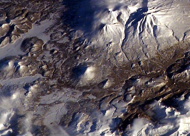
Khodutka is located in Russia, within the Kuril Volcanic Arc of the broader Northwestern Pacific Volcanic Regions. Situated at 52.06° N, 157.71° E in the Northern Hemisphere, the volcano lies within a temperate climate zone. At 2,039 meters above sea level, Khodutka rises above the surrounding terrain into montane or subalpine conditions. The elevation creates distinct ecological zones along its flanks, from forested lower slopes to exposed rocky terrain near the summit. The volcanic landform is characterized as a composite, which describes the physical shape and structure of the volcanic edifice as observed from the surface.
Geological Context
Khodutka sits in a subduction zone, where one tectonic plate dives beneath another, creating intense heat and pressure that generates magma. Subduction zones are responsible for many of the world's most explosive volcanoes and deadliest eruptions. For communities in Russia near Khodutka, this tectonic setting means the volcano is capable of producing powerful explosive eruptions, pyroclastic flows, and lahars that can threaten populated areas within tens of kilometers of the summit. The dominant rock type is andesite / basaltic andesite, a dark, fine-grained volcanic rock that forms from rapidly cooling, low-viscosity lava. Basaltic eruptions tend to be less explosive and produce fluid lava flows that can travel long distances. While less immediately dangerous than explosive eruptions, basaltic lava flows can destroy structures and infrastructure in their path, and volcanic gases released during these eruptions can affect air quality over a wide area.
Eruption History Summary
Khodutka has 3 recorded eruptions in the geological database, spanning from 1050 BCE to 300 BCE. The most powerful recorded event was a paroxysmal eruption with devastating regional consequences in 930 BCE, reaching VEI 5 on the Volcanic Explosivity Index. Notable eruptions include 930 BCE (VEI 5), 1050 BCE (VEI 4). These eruptions span roughly 750 years of volcanic history.
Significance
With a maximum recorded VEI of 5, Khodutka has demonstrated the capacity for paroxysmal eruptions comparable to the 1980 eruption of Mount St. Helens. Eruptions of this scale can devastate areas within 20-30 kilometers and produce ash fall that disrupts aviation and agriculture across hundreds of kilometers.
GVP Reference Summary
Khodutka stratovolcano was formed during the late-Pleistocene to early Holocene, partially covering the older Priemysh stratovolcano on the NW flank. At least 10 explosion craters, small lava cones, and lava domes are located along the flanks, and cinder cones produced by regional basaltic volcanism occur to the west. The Khodutkinsky maar on the WNW flank was created about 2,800 years ago during an eruption that deposited tephra across much of southern Kamchatka. Formation of the maar was accompanied by small pyroclastic flows, followed by emplacement of lava flows and domes. The last dated eruption took place from the summit vent about 2,000-2,500 years ago. The Khodutka Springs geothermal field occupies an explosion crater on the NW flank of Priemysh.
— Smithsonian Institution, Global Volcanism Program
3 Recorded Eruptions
| Year | VEI | Type | Area |
|---|---|---|---|
| 300 BCE | 0 | Confirmed Eruption | — |
| 930 BCE | 5 | Confirmed Eruption | WNW flank (Khodutkinsky maar) |
| 1050 BCE | 4 | Confirmed Eruption | NW flank of Priemysh volcano |
Real-Time Data
Frequently Asked Questions About Khodutka
Is Khodutka an active volcano?+
Khodutka is not currently classified as active. Its activity evidence is listed as "Eruption Dated." The last known eruption was in 300 BCE. However, no volcano is ever considered permanently extinct.
When did Khodutka last erupt?+
The most recent recorded eruption of Khodutka occurred in 300 BCE with a Volcanic Explosivity Index (VEI) of 0. The eruption was classified as a "Confirmed Eruption." Khodutka has 3 recorded eruptions in total.
How high is Khodutka?+
Khodutka has a summit elevation of 2,039 meters (6,690 feet) above sea level. At 2,039 meters, it is comparable in height to many significant mountain peaks and stands well above the tree line.
What type of volcano is Khodutka?+
Khodutka is classified as a Stratovolcano(es). Stratovolcano(es) volcanoes have distinct geological characteristics that set them apart from other volcanic types.
Where is Khodutka located?+
Khodutka is located in Russia, in the Northwestern Pacific Volcanic Regions. More specifically, it lies within the Kuril Volcanic Arc. Its exact coordinates are 52.062° latitude, 157.711° longitude.
Is it safe to visit Khodutka?+
Khodutka can generally be visited, but as with any volcano, visitors should check local conditions and any advisory notices before traveling. Russia may have specific regulations for accessing volcanic areas. Guided tours are often the safest and most informative way to experience a volcano.