About Mashu
Mashu is a caldera rising to 857 meters (2,812 feet) in Japan's Northwestern Pacific Volcanic Regions. Its last known eruption was in 1080 CE. The volcano has produced 7 recorded eruptions, with a maximum Volcanic Explosivity Index (VEI) of 6.
Geography & Climate
Mashu is located in Japan, within the Kuril Volcanic Arc of the broader Northwestern Pacific Volcanic Regions. Situated at 43.57° N, 144.56° E in the Northern Hemisphere, the volcano lies within a temperate climate zone. With a summit elevation of 857 meters above sea level, Mashu is a moderately sized peak that remains accessible to hikers and researchers for much of the year. The volcanic landform is characterized as a caldera, which describes the physical shape and structure of the volcanic edifice as observed from the surface.
Geological Context
Mashu sits in a subduction zone, where one tectonic plate dives beneath another, creating intense heat and pressure that generates magma. Subduction zones are responsible for many of the world's most explosive volcanoes and deadliest eruptions. For communities in Japan near Mashu, this tectonic setting means the volcano is capable of producing powerful explosive eruptions, pyroclastic flows, and lahars that can threaten populated areas within tens of kilometers of the summit. The dominant rock type is andesite / basaltic andesite, a dark, fine-grained volcanic rock that forms from rapidly cooling, low-viscosity lava. Basaltic eruptions tend to be less explosive and produce fluid lava flows that can travel long distances. While less immediately dangerous than explosive eruptions, basaltic lava flows can destroy structures and infrastructure in their path, and volcanic gases released during these eruptions can affect air quality over a wide area.
Eruption History Summary
Mashu has 7 recorded eruptions in the geological database, spanning from 5550 BCE to 1080 CE. The most powerful recorded event was a colossal eruption capable of affecting global climate for years in 5550 BCE, reaching VEI 6 on the Volcanic Explosivity Index. Notable eruptions include 1080 CE (VEI 5), 150 CE (VEI 4), 2050 BCE (VEI 4). This eruption frequency indicates a moderately active volcanic system with periodic reawakenings.
Significance
Mashu has produced at least one eruption of VEI 6 or higher, placing it among the most powerful volcanic systems on Earth. Eruptions of this magnitude inject massive quantities of sulfur dioxide into the stratosphere, affecting global climate by lowering average temperatures for one to three years after the event. With 7 recorded eruptions on file, Mashu has enough documented activity to help scientists identify patterns in its eruptive behavior.
GVP Reference Summary
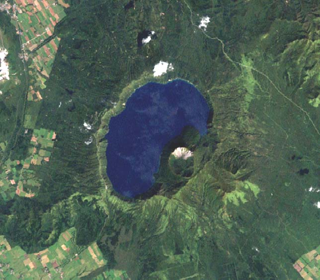
Mashu is a 6-km-wide Holocene caldera that truncates a stratovolcano constructed on the ESE rim of the large Kussharo caldera. The steep-walled caldera, filled by Lake Mashu, is one of the scenic highlights of Hokkaido. Following caldera collapse about 7,000 years ago, a small andesitic stratovolcano, Kamuinupuri, was formed beginning about 4,000 years ago, creating a reentrant into the SE side of the deep caldera lake. A large explosive eruption about 1,000 years ago, the latest dated eruption, created a 1.2 x 1.5 km crater at the summit of Kamuinupuri. The small island of Kamuishu in the center of Lake Mashu represents the tip of a mostly submerged dacitic lava dome.
— Smithsonian Institution, Global Volcanism Program
7 Recorded Eruptions
| Year | VEI | Type | Area |
|---|---|---|---|
| 1080 | 5 | Confirmed Eruption | Kamuinupuri |
| 350 | 2 | Confirmed Eruption | Kamuinupuri |
| 150 | 4 | Confirmed Eruption | Kamuinupuri |
| 2050 BCE | 4 | Confirmed Eruption | Kamuinupuri |
| 2800 BCE | 3 | Confirmed Eruption | Kamuinupuri |
| 3550 BCE | 4 | Confirmed Eruption | Kamuinupuri |
| 5550 BCE | 6 | Confirmed Eruption | — |
Real-Time Data
Frequently Asked Questions About Mashu
Is Mashu an active volcano?+
Mashu is not currently classified as active. Its activity evidence is listed as "Eruption Dated." The last known eruption was in 1080 CE. However, no volcano is ever considered permanently extinct.
When did Mashu last erupt?+
The most recent recorded eruption of Mashu occurred in 1080 CE with a Volcanic Explosivity Index (VEI) of 5. The eruption was classified as a "Confirmed Eruption." Mashu has 7 recorded eruptions in total.
How high is Mashu?+
Mashu has a summit elevation of 857 meters (2,812 feet) above sea level. At 857 meters, it is a relatively low-elevation volcano.
What type of volcano is Mashu?+
Mashu is classified as a Caldera. Calderas are large volcanic depressions formed when a volcano erupts so powerfully that its magma chamber collapses, creating a basin that can be kilometers wide. They are often sites of some of Earth's largest eruptions.
Where is Mashu located?+
Mashu is located in Japan, in the Northwestern Pacific Volcanic Regions. More specifically, it lies within the Kuril Volcanic Arc. Its exact coordinates are 43.572° latitude, 144.561° longitude.
Is it safe to visit Mashu?+
Mashu can generally be visited, but as with any volcano, visitors should check local conditions and any advisory notices before traveling. Japan may have specific regulations for accessing volcanic areas. Guided tours are often the safest and most informative way to experience a volcano.


