About Anatahan
Anatahan is a stratovolcano rising to 790 meters (2,592 feet) in United States's Northwestern Pacific Volcanic Regions. It has been active in recent decades, with its last eruption in 2008 CE. The volcano has produced 4 recorded eruptions, with a maximum Volcanic Explosivity Index (VEI) of 3.
Geography & Climate
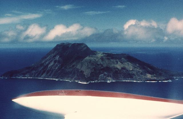
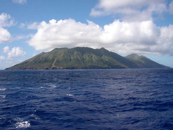
Anatahan is located in United States, within the Mariana Volcanic Arc of the broader Northwestern Pacific Volcanic Regions. Situated at 16.35° N, 145.67° E in the Northern Hemisphere, the volcano lies within a tropical climate zone. With a summit elevation of 790 meters above sea level, Anatahan is a moderately sized peak that remains accessible to hikers and researchers for much of the year. The volcanic landform is characterized as a composite, which describes the physical shape and structure of the volcanic edifice as observed from the surface.
Geological Context
Anatahan sits in a subduction zone, where one tectonic plate dives beneath another, creating intense heat and pressure that generates magma. Subduction zones are responsible for many of the world's most explosive volcanoes and deadliest eruptions. For communities in United States near Anatahan, this tectonic setting means the volcano is capable of producing powerful explosive eruptions, pyroclastic flows, and lahars that can threaten populated areas within tens of kilometers of the summit. The dominant rock type is andesite / basaltic andesite, a dark, fine-grained volcanic rock that forms from rapidly cooling, low-viscosity lava. Basaltic eruptions tend to be less explosive and produce fluid lava flows that can travel long distances. While less immediately dangerous than explosive eruptions, basaltic lava flows can destroy structures and infrastructure in their path, and volcanic gases released during these eruptions can affect air quality over a wide area.
Eruption History Summary
Anatahan has 4 recorded eruptions in the geological database, spanning from 2003 CE to 2007 CE. The most powerful recorded event was a severe eruption capable of regional ash fall and pyroclastic flows in 2004 CE, reaching VEI 3 on the Volcanic Explosivity Index. Notable eruptions include 2004 CE (VEI 3), 2003 CE (VEI 3). These eruptions span roughly 4 years of volcanic history. With eruptive activity as recently as 2007 CE, Anatahan remains an actively monitored volcano.
Significance
With a maximum recorded VEI of 3, Anatahan has produced eruptions capable of generating pyroclastic flows and significant ash fall in the surrounding area. While not among the largest eruptions globally, VEI 3 events pose serious hazards to local populations and can disrupt regional air travel. Given its recent activity, Anatahan is closely monitored by geological survey organizations to provide early warning of future unrest.
GVP Reference Summary
The elongate, 9-km-long island of Anatahan in the central Mariana Islands consists of a large stratovolcano with a 2.3 x 5 km compound summit caldera. The larger western portion of the caldera is 2.3 x 3 km wide, and its western rim forms the island's high point. Ponded lava flows overlain by pyroclastic deposits fill the floor of the western caldera, whose SW side is cut by a fresh-looking smaller crater. The 2-km-wide eastern portion of the caldera contained a steep-walled inner crater whose floor prior to the 2003 eruption was only 68 m above sea level. A submarine cone, named NE Anatahan, rises to within 460 m of the sea surface on the NE flank, and numerous other submarine vents are found on the NE-to-SE flanks. Sparseness of vegetation on the most recent lava flows had indicated that they were of Holocene age, but the first historical eruption did not occur until May 2003, when a large explosive eruption took place forming a new crater inside the eastern caldera.
— Smithsonian Institution, Global Volcanism Program
4 Recorded Eruptions
| Year | VEI | Type | Area |
|---|---|---|---|
| 2007 | 2 | Confirmed Eruption | — |
| 2006 | 2 | Confirmed Eruption | East Crater |
| 2004 | 3 | Confirmed Eruption | East Crater |
| 2003 | 3 | Confirmed Eruption | East Crater |
Real-Time Data
Frequently Asked Questions About Anatahan
Is Anatahan an active volcano?+
Yes, Anatahan is considered an active volcano. Its most recent eruption was in 2008 CE. The volcano is monitored by geological agencies, and its activity status is based on observed eruptions within recorded history.
When did Anatahan last erupt?+
The most recent recorded eruption of Anatahan occurred in 2007 CE with a Volcanic Explosivity Index (VEI) of 2. The eruption was classified as a "Confirmed Eruption." Anatahan has 4 recorded eruptions in total.
How high is Anatahan?+
Anatahan has a summit elevation of 790 meters (2,592 feet) above sea level. At 790 meters, it is a relatively low-elevation volcano.
What type of volcano is Anatahan?+
Anatahan is classified as a Stratovolcano. Stratovolcanoes (also called composite volcanoes) are steep, conical volcanoes built up by many layers of hardened lava, tephra, and volcanic ash. They are among the most common and dangerous types, known for explosive eruptions.
Where is Anatahan located?+
Anatahan is located in United States, in the Northwestern Pacific Volcanic Regions. More specifically, it lies within the Mariana Volcanic Arc. Its exact coordinates are 16.350° latitude, 145.670° longitude.
Is it safe to visit Anatahan?+
Visiting Anatahan requires checking current volcanic activity and alert levels. As an active volcano with eruptions as recent as 2008 CE, conditions can change rapidly. Always consult local geological authorities and follow official warnings before visiting. Many active volcanoes have designated safe viewing areas and guided tour options.