About Ma Alalta
Ma Alalta is a stratovolcano rising to 1,745 meters (5,725 feet) in Ethiopia's Eastern Africa Volcanic Regions. No historical eruptions have been recorded, though the volcano is classified based on geological evidence of past activity.
Geography & Climate
Ma Alalta is located in Ethiopia, within the Afar Rift Volcanic Province of the broader Eastern Africa Volcanic Regions. Situated at 13.01° N, 40.19° E in the Northern Hemisphere, the volcano lies within a tropical climate zone. With a summit elevation of 1,745 meters above sea level, Ma Alalta is a moderately sized peak that remains accessible to hikers and researchers for much of the year. The volcanic landform is characterized as a composite, which describes the physical shape and structure of the volcanic edifice as observed from the surface.
Geological Context
Ma Alalta is situated along a rift zone, where tectonic plates are pulling apart. As the crust thins and fractures, magma rises to fill the gap, creating volcanic activity. Rift volcanism typically produces more fluid lava flows rather than explosive blasts, which means communities near Ma Alalta in Ethiopia generally face slower-moving hazards like lava flows and ground fissures rather than sudden pyroclastic events. However, rift volcanoes can still generate significant ash emissions and gas releases that affect local air quality. The dominant rock type is rhyolite, a silica-rich volcanic rock associated with highly viscous magma. Rhyolitic eruptions can be extremely explosive and are responsible for some of the largest volcanic events in Earth's history, including supervolcanic caldera-forming eruptions. The high silica content traps dissolved gases, building enormous pressure that can lead to catastrophic explosive releases.
GVP Reference Summary
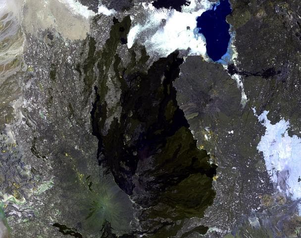
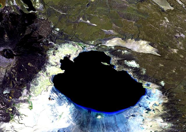
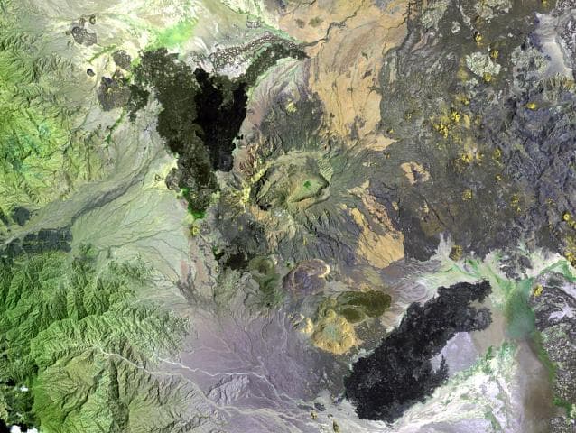
The Ma Alalta stratovolcano, also known as Pierre Pruvost, is located well to the west of the Danakil depression at the foot of the regional Ethiopian scarp, between two large horsts of uplifted basement blocks. A large trachytic and rhyolitic stratovolcano at the center of the complex contains nested oval-shaped summit calderas, 8 x 5 km and 5 x 2.5 km. Ignimbrite deposits, perhaps associated with formation of the larger caldera, extend beyond the volcano primarily to the NE and SE. Young basaltic lava flows were erupted on the NW, SE, and E flanks. Recent silicic activity has produced pantelleritic obsidian domes and lava flows on the southern flank. Fumarolic activity continues at one of the domes.
— Smithsonian Institution, Global Volcanism Program
0 Recorded Eruptions
No eruption records available for Ma Alalta.
Real-Time Data
Frequently Asked Questions About Ma Alalta
Is Ma Alalta an active volcano?+
Ma Alalta is classified as active based on credible evidence of past eruptions. Although its last known eruption was in prehistoric times, volcanologists consider it capable of erupting again.
How high is Ma Alalta?+
Ma Alalta has a summit elevation of 1,745 meters (5,725 feet) above sea level. At 1,745 meters, it is a moderately sized volcanic peak, roughly comparable to Mount Vesuvius (1,281m).
What type of volcano is Ma Alalta?+
Ma Alalta is classified as a Stratovolcano. Stratovolcanoes (also called composite volcanoes) are steep, conical volcanoes built up by many layers of hardened lava, tephra, and volcanic ash. They are among the most common and dangerous types, known for explosive eruptions.
Where is Ma Alalta located?+
Ma Alalta is located in Ethiopia, in the Eastern Africa Volcanic Regions. More specifically, it lies within the Afar Rift Volcanic Province. Its exact coordinates are 13.013° latitude, 40.185° longitude.
Is it safe to visit Ma Alalta?+
Ma Alalta can generally be visited, but as with any volcano, visitors should check local conditions and any advisory notices before traveling. Ethiopia may have specific regulations for accessing volcanic areas. Guided tours are often the safest and most informative way to experience a volcano.