About Hayli Gubbi
Hayli Gubbi is a shield rising to 493 meters (1,618 feet) in Ethiopia's Eastern Africa Volcanic Regions. The volcano is currently active, with its most recent eruption in 2025 CE. The volcano has produced 2 recorded eruptions.
Geography & Climate
Hayli Gubbi is located in Ethiopia, within the Afar Rift Volcanic Province of the broader Eastern Africa Volcanic Regions. Situated at 13.51° N, 40.72° E in the Northern Hemisphere, the volcano lies within a tropical climate zone. At just 493 meters above sea level, Hayli Gubbi is a relatively low-elevation volcanic feature. Despite its modest height, it remains an active geological formation with the same underlying magmatic processes as its taller counterparts. The volcanic landform is characterized as a shield, which describes the physical shape and structure of the volcanic edifice as observed from the surface.
Geological Context
Hayli Gubbi is situated along a rift zone, where tectonic plates are pulling apart. As the crust thins and fractures, magma rises to fill the gap, creating volcanic activity. Rift volcanism typically produces more fluid lava flows rather than explosive blasts, which means communities near Hayli Gubbi in Ethiopia generally face slower-moving hazards like lava flows and ground fissures rather than sudden pyroclastic events. However, rift volcanoes can still generate significant ash emissions and gas releases that affect local air quality. The dominant rock type is basalt / picro-basalt, a dark, fine-grained volcanic rock that forms from rapidly cooling, low-viscosity lava. Basaltic eruptions tend to be less explosive and produce fluid lava flows that can travel long distances. While less immediately dangerous than explosive eruptions, basaltic lava flows can destroy structures and infrastructure in their path, and volcanic gases released during these eruptions can affect air quality over a wide area.
Eruption History Summary
Hayli Gubbi has 2 recorded eruptions in the geological database, spanning from 6250 BCE to 2025 CE. These eruptions span roughly 8,275 years of volcanic history. With eruptive activity as recently as 2025 CE, Hayli Gubbi remains an actively monitored volcano.
GVP Reference Summary
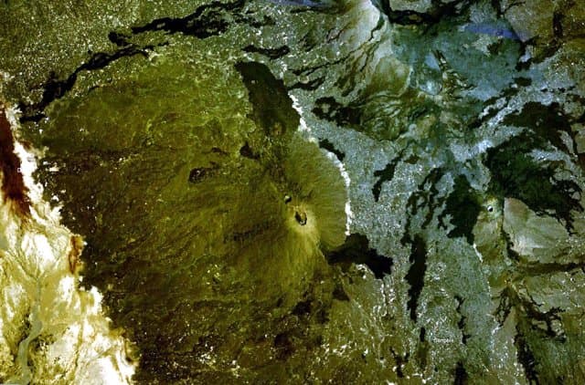
Hayli Gubbi is the southernmost volcano of the Erta Ale Range. Recent tectonism has created a NW-SE graben across the summit, with a 380-m-diameter scoria cone at the summit and a 260-m-diameter crater displaying fumarolic activity. A sequence of fissure vents and lava fields extends 6 km NW to the southern caldera of Erta Ale. Additional dark flows that originated from the summit area cover the W and NE flanks, and SE before turning E at the base on the shield. More fissure vents extend ~3.5 km SSE within the graben to another small shield. From there, the line of vents continues, along with a lava field that spreads across the Afrera Plain, to a distance of 25 km from the summit crater. Barberi and Varet (1970) reported that those basaltic flow fronts covered sediments in the plain which Roubet et al. (1969) described as lacustrine limestones and diatomites deposited around 8,200 years BP above hyaloclastite formations. This places the eruption of the SE-most flows sometime within the last 8,000 years, but no additional information about how recent they might be is known; in appearance they are similar to very recent flows from the Erta Ale shield. On 15 July 2025 a dike intrusion that originated at the Erta Ale N caldera pit craters produced active fissure vents and lava flows within and on the S flanks of the south caldera; another set of fissure vents were active 4 km SE from the caldera rim, within 2 km of the Hayli Gubbi crater. A large explosive eruption on 23 November 2025 excavated the previous summit cone and created a second large crater (~200 m in diameter) in the summit area, and a third smaller crater.
— Smithsonian Institution, Global Volcanism Program
2 Recorded Eruptions
| Year | VEI | Type | Area |
|---|---|---|---|
| 2025 | — | Confirmed Eruption | — |
| 6250 BCE | — | Confirmed Eruption | S flank |
Real-Time Data
Frequently Asked Questions About Hayli Gubbi
Is Hayli Gubbi an active volcano?+
Yes, Hayli Gubbi is considered an active volcano. Its most recent eruption was in 2025 CE. The volcano is monitored by geological agencies, and its activity status is based on observed eruptions within recorded history.
When did Hayli Gubbi last erupt?+
The most recent recorded eruption of Hayli Gubbi occurred in 2025 CE. The eruption was classified as a "Confirmed Eruption." Hayli Gubbi has 2 recorded eruptions in total.
How high is Hayli Gubbi?+
Hayli Gubbi has a summit elevation of 493 meters (1,618 feet) above sea level. At 493 meters, it is a relatively low-elevation volcano.
What type of volcano is Hayli Gubbi?+
Hayli Gubbi is classified as a Shield. Shield volcanoes have distinct geological characteristics that set them apart from other volcanic types.
Where is Hayli Gubbi located?+
Hayli Gubbi is located in Ethiopia, in the Eastern Africa Volcanic Regions. More specifically, it lies within the Afar Rift Volcanic Province. Its exact coordinates are 13.511° latitude, 40.716° longitude.
Is it safe to visit Hayli Gubbi?+
Visiting Hayli Gubbi requires checking current volcanic activity and alert levels. As an active volcano with eruptions as recent as 2025 CE, conditions can change rapidly. Always consult local geological authorities and follow official warnings before visiting. Many active volcanoes have designated safe viewing areas and guided tour options.