About Erta Ale
Erta Ale is a shield rising to 585 meters (1,919 feet) in Ethiopia's Eastern Africa Volcanic Regions. The volcano is currently active, with its most recent eruption in 2025 CE. The volcano has produced 7 recorded eruptions, with a maximum Volcanic Explosivity Index (VEI) of 2.
Geography & Climate
Erta Ale is located in Ethiopia, within the Afar Rift Volcanic Province of the broader Eastern Africa Volcanic Regions. Situated at 13.60° N, 40.67° E in the Northern Hemisphere, the volcano lies within a tropical climate zone. With a summit elevation of 585 meters above sea level, Erta Ale is a moderately sized peak that remains accessible to hikers and researchers for much of the year. The volcanic landform is characterized as a shield, which describes the physical shape and structure of the volcanic edifice as observed from the surface.
Geological Context
Erta Ale is situated along a rift zone, where tectonic plates are pulling apart. As the crust thins and fractures, magma rises to fill the gap, creating volcanic activity. Rift volcanism typically produces more fluid lava flows rather than explosive blasts, which means communities near Erta Ale in Ethiopia generally face slower-moving hazards like lava flows and ground fissures rather than sudden pyroclastic events. However, rift volcanoes can still generate significant ash emissions and gas releases that affect local air quality. The dominant rock type is basalt / picro-basalt, a dark, fine-grained volcanic rock that forms from rapidly cooling, low-viscosity lava. Basaltic eruptions tend to be less explosive and produce fluid lava flows that can travel long distances. While less immediately dangerous than explosive eruptions, basaltic lava flows can destroy structures and infrastructure in their path, and volcanic gases released during these eruptions can affect air quality over a wide area.
Eruption History Summary
Erta Ale has 7 recorded eruptions in the geological database, spanning from 1873 CE to 1967 CE. The most powerful recorded event was an explosive event producing ash plumes up to several kilometers in 1904 CE, reaching VEI 2 on the Volcanic Explosivity Index. This eruption frequency indicates a moderately active volcanic system with periodic reawakenings. The most recent eruption in 1967 CE places this volcano within the modern era of volcanological observation.
Significance
With 7 recorded eruptions on file, Erta Ale has enough documented activity to help scientists identify patterns in its eruptive behavior. Given its recent activity, Erta Ale is closely monitored by geological survey organizations to provide early warning of future unrest.
GVP Reference Summary
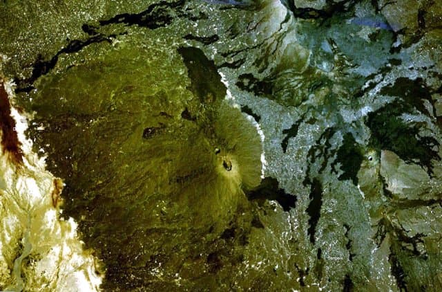
The Erta Ale basaltic shield volcano in Ethiopia has a 50-km-wide edifice that rises more than 600 m from below sea level in the Danakil depression. The volcano includes a 0.7 x 1.6 km summit crater hosting steep-sided pit craters. Another larger 1.8 x 3.1 km wide depression elongated parallel to the trend of the Erta Ale range is located SE of the summit and is bounded by curvilinear fault scarps on the SE side. Basaltic lava flows from these fissures have poured into the caldera and locally overflowed its rim. The summit caldera usually also holds at least one long-term lava lake that has been active since at least 1967, and possibly since 1906. Recent fissure eruptions have occurred on the N flank.
— Smithsonian Institution, Global Volcanism Program
7 Recorded Eruptions
| Year | VEI | Type | Area |
|---|---|---|---|
| 1967 | 0 | Confirmed Eruption | — |
| 1960 | 0 | Confirmed Eruption | — |
| 1940 | 0 | Confirmed Eruption | — |
| 1906 | 0 | Confirmed Eruption | — |
| 1904 | 2 | Uncertain Eruption | — |
| 1903 | 2 | Uncertain Eruption | — |
| 1873 | 2 | Uncertain Eruption | — |
Real-Time Data
Frequently Asked Questions About Erta Ale
Is Erta Ale an active volcano?+
Yes, Erta Ale is considered an active volcano. Its most recent eruption was in 2025 CE. The volcano is monitored by geological agencies, and its activity status is based on observed eruptions within recorded history.
When did Erta Ale last erupt?+
The most recent recorded eruption of Erta Ale occurred in 1967 CE with a Volcanic Explosivity Index (VEI) of 0. The eruption was classified as a "Confirmed Eruption." Erta Ale has 7 recorded eruptions in total.
How high is Erta Ale?+
Erta Ale has a summit elevation of 585 meters (1,919 feet) above sea level. At 585 meters, it is a relatively low-elevation volcano.
What type of volcano is Erta Ale?+
Erta Ale is classified as a Shield. Shield volcanoes have distinct geological characteristics that set them apart from other volcanic types.
Where is Erta Ale located?+
Erta Ale is located in Ethiopia, in the Eastern Africa Volcanic Regions. More specifically, it lies within the Afar Rift Volcanic Province. Its exact coordinates are 13.601° latitude, 40.666° longitude.
Is it safe to visit Erta Ale?+
Visiting Erta Ale requires checking current volcanic activity and alert levels. As an active volcano with eruptions as recent as 2025 CE, conditions can change rapidly. Always consult local geological authorities and follow official warnings before visiting. Many active volcanoes have designated safe viewing areas and guided tour options.