About Gaua
Gaua is a stratovolcano rising to 729 meters (2,392 feet) in Vanuatu's Southwestern Pacific Volcanic Regions. The volcano is currently active, with its most recent eruption in 2022 CE. The volcano has produced 18 recorded eruptions, with a maximum Volcanic Explosivity Index (VEI) of 3.
Geography & Climate
Gaua is located in Vanuatu, within the Vanuatu Volcanic Arc of the broader Southwestern Pacific Volcanic Regions. Situated at 14.28° S, 167.51° E in the Southern Hemisphere, the volcano lies within a tropical climate zone. With a summit elevation of 729 meters above sea level, Gaua is a moderately sized peak that remains accessible to hikers and researchers for much of the year. The volcanic landform is characterized as a composite, which describes the physical shape and structure of the volcanic edifice as observed from the surface.
Geological Context
Gaua sits in a subduction zone, where one tectonic plate dives beneath another, creating intense heat and pressure that generates magma. Subduction zones are responsible for many of the world's most explosive volcanoes and deadliest eruptions. For communities in Vanuatu near Gaua, this tectonic setting means the volcano is capable of producing powerful explosive eruptions, pyroclastic flows, and lahars that can threaten populated areas within tens of kilometers of the summit. The dominant rock type is andesite / basaltic andesite, a dark, fine-grained volcanic rock that forms from rapidly cooling, low-viscosity lava. Basaltic eruptions tend to be less explosive and produce fluid lava flows that can travel long distances. While less immediately dangerous than explosive eruptions, basaltic lava flows can destroy structures and infrastructure in their path, and volcanic gases released during these eruptions can affect air quality over a wide area.
Eruption History Summary
Gaua has 18 recorded eruptions in the geological database, spanning from 1962 CE to 2022 CE. The most powerful recorded event was a severe eruption capable of regional ash fall and pyroclastic flows in 1965 CE, reaching VEI 3 on the Volcanic Explosivity Index. This level of eruptive frequency indicates a persistently active volcanic system that warrants ongoing monitoring. With eruptive activity as recently as 2022 CE, Gaua remains an actively monitored volcano.
Significance
With a maximum recorded VEI of 3, Gaua has produced eruptions capable of generating pyroclastic flows and significant ash fall in the surrounding area. While not among the largest eruptions globally, VEI 3 events pose serious hazards to local populations and can disrupt regional air travel. With 18 recorded eruptions, Gaua has a substantial eruptive history that provides valuable data for understanding volcanic behavior and assessing future hazards in the Southwestern Pacific Volcanic Regions region. Given its recent activity, Gaua is closely monitored by geological survey organizations to provide early warning of future unrest.
GVP Reference Summary
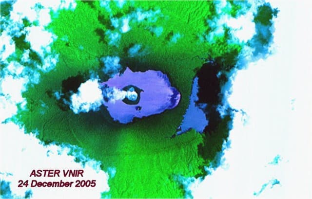
The roughly 20-km-diameter Gaua Island, also known as Santa Maria, consists of a basaltic-to-andesitic stratovolcano with an 6 x 9 km summit caldera. Small vents near the caldera rim fed Pleistocene lava flows that reached the coast on several sides of the island; littoral cones were formed where these lava flows reached the ocean. Quiet collapse that formed the roughly 700-m-deep caldera was followed by extensive ash eruptions. The active Mount Garet (or Garat) cone in the SW part of the caldera has three pit craters across the summit area. Construction of Garet and other small cinder cones has left a crescent-shaped lake. The onset of eruptive activity from a vent high on the SE flank in 1962 ended a long period of dormancy.
— Smithsonian Institution, Global Volcanism Program
18 Recorded Eruptions
| Year | VEI | Type | Area |
|---|---|---|---|
| 2022 | 1 | Confirmed Eruption | Mt. Garet |
| 2021 | 1 | Confirmed Eruption | Mt. Garet |
| 2011 | 1 | Confirmed Eruption | Mt. Garat |
| 2009 | 2 | Confirmed Eruption | Mt. Garat |
| 1982 | 2 | Confirmed Eruption | Mt. Garat |
| 1981 | 1 | Confirmed Eruption | Mt. Garat |
| 1980 | 1 | Confirmed Eruption | Mt. Garat |
| 1977 | 2 | Confirmed Eruption | Mt. Garat |
| 1976 | 2 | Confirmed Eruption | Mt. Garat |
| 1973 | 2 | Confirmed Eruption | Mt. Garat (upper SE flank) |
| 1971 | 2 | Confirmed Eruption | Mt. Garat (upper SE flank) |
| 1969 | 2 | Confirmed Eruption | Mt. Garat |
| 1968 | 2 | Confirmed Eruption | Mt. Garat (upper SE flank) |
| 1967 | 2 | Confirmed Eruption | Mt. Garat |
| 1966 | 2 | Confirmed Eruption | Mt. Garat |
| 1965 | 3 | Confirmed Eruption | Mt. Garat |
| 1963 | 2 | Confirmed Eruption | Mt. Garat (upper SE flank) |
| 1962 | 2 | Confirmed Eruption | Mt. Garat |
Real-Time Data
Frequently Asked Questions About Gaua
Is Gaua an active volcano?+
Yes, Gaua is considered an active volcano. Its most recent eruption was in 2022 CE. The volcano is monitored by geological agencies, and its activity status is based on observed eruptions within recorded history.
When did Gaua last erupt?+
The most recent recorded eruption of Gaua occurred in 2022 CE with a Volcanic Explosivity Index (VEI) of 1. The eruption was classified as a "Confirmed Eruption." Gaua has 18 recorded eruptions in total.
How high is Gaua?+
Gaua has a summit elevation of 729 meters (2,392 feet) above sea level. At 729 meters, it is a relatively low-elevation volcano.
What type of volcano is Gaua?+
Gaua is classified as a Stratovolcano. Stratovolcanoes (also called composite volcanoes) are steep, conical volcanoes built up by many layers of hardened lava, tephra, and volcanic ash. They are among the most common and dangerous types, known for explosive eruptions.
Where is Gaua located?+
Gaua is located in Vanuatu, in the Southwestern Pacific Volcanic Regions. More specifically, it lies within the Vanuatu Volcanic Arc. Its exact coordinates are -14.281° latitude, 167.514° longitude.
Is it safe to visit Gaua?+
Visiting Gaua requires checking current volcanic activity and alert levels. As an active volcano with eruptions as recent as 2022 CE, conditions can change rapidly. Always consult local geological authorities and follow official warnings before visiting. Many active volcanoes have designated safe viewing areas and guided tour options.