About Koussi, Emi
Koussi, Emi is a shield(pyroclastic) rising to 3,415 meters (11,205 feet) in Chad's Northern Africa Volcanic Regions. No historical eruptions have been recorded, though the volcano is classified based on geological evidence of past activity.
Geography & Climate
Koussi, Emi is located in Chad, within the East Central Sahara Volcanic Province of the broader Northern Africa Volcanic Regions. Situated at 19.80° N, 18.53° E in the Northern Hemisphere, the volcano lies within a tropical climate zone. At 3,415 meters above sea level, Koussi, Emi rises above the surrounding terrain into montane or subalpine conditions. The elevation creates distinct ecological zones along its flanks, from forested lower slopes to exposed rocky terrain near the summit. The volcanic landform is characterized as a shield, which describes the physical shape and structure of the volcanic edifice as observed from the surface.
Geological Context
Koussi, Emi is an intraplate volcano, meaning it formed away from any plate boundary. These volcanoes are often powered by hotspots — plumes of abnormally hot mantle material rising from deep within the Earth. Hotspot volcanoes like Koussi, Emi tend to produce effusive eruptions with lava flows that can be relatively predictable, giving nearby communities in Chad more time to prepare. However, they can also produce explosive phases, particularly when magma interacts with groundwater. The dominant rock type is trachyte / trachydacite, an intermediate to silica-rich volcanic rock. This composition typically produces more viscous magma, leading to more explosive eruptions with ash columns and pyroclastic flows. Andesitic and dacitic magmas build pressure before erupting, which is why volcanoes with this rock chemistry are often associated with Plinian-style eruptions that can send ash tens of kilometers into the atmosphere and disrupt aviation across entire regions.
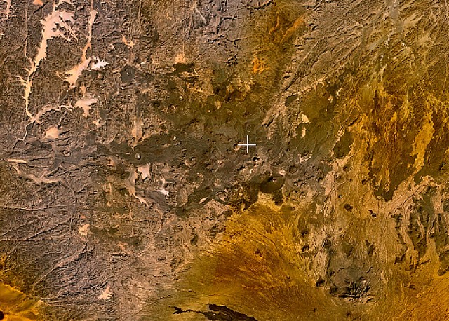
GVP Reference Summary
The large Emi Koussi volcano at the SE end of the Tibesti Range, a 60 x 80 km massif constructed over a basement of Cretaceous and Paleozoic sandstones, forms the highest summit of the Sahara. Two nested calderas, 12 x 15 km, truncate the dominantly trachytic volcano, whose high point lies on the southern caldera rim of the low-angle pyroclastic shield volcano. The calderas contain several explosion craters, lava domes, and young scoria cones, along with lava flows of recent and pre-modern age (Geze et al., 1959). The Era Kohor (Trou au Natron du Koussi) caldera on the SE floor of the 2nd caldera is 2-3 km wide and 350 m deep. The latest activity in the calderas produced three maars, and numerous basaltic cinder cones; associated lava flows have been constructed both within the calderas and on their outer flanks. The Yi-Yerra thermal area is located on the S flank.
— Smithsonian Institution, Global Volcanism Program
0 Recorded Eruptions
No eruption records available for Koussi, Emi.
Real-Time Data
Frequently Asked Questions About Koussi, Emi
Is Koussi, Emi an active volcano?+
Koussi, Emi is classified as active based on credible evidence of past eruptions. Although its last known eruption was in prehistoric times, volcanologists consider it capable of erupting again.
How high is Koussi, Emi?+
Koussi, Emi has a summit elevation of 3,415 meters (11,205 feet) above sea level. At 3,415 meters, it is comparable in height to many significant mountain peaks and stands well above the tree line.
What type of volcano is Koussi, Emi?+
Koussi, Emi is classified as a Shield(pyroclastic). Shield(pyroclastic) volcanoes have distinct geological characteristics that set them apart from other volcanic types.
Where is Koussi, Emi located?+
Koussi, Emi is located in Chad, in the Northern Africa Volcanic Regions. More specifically, it lies within the East Central Sahara Volcanic Province. Its exact coordinates are 19.800° latitude, 18.530° longitude.
Is it safe to visit Koussi, Emi?+
Koussi, Emi can generally be visited, but as with any volcano, visitors should check local conditions and any advisory notices before traveling. Chad may have specific regulations for accessing volcanic areas. Guided tours are often the safest and most informative way to experience a volcano.