About Bravo, Cerro
Bravo, Cerro is a stratovolcano rising to 3,985 meters (13,075 feet) in Colombia's South America Volcanic Regions. Its last known eruption was in 1720 CE. The volcano has produced 8 recorded eruptions, with a maximum Volcanic Explosivity Index (VEI) of 4.
Geography & Climate
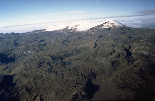
Bravo, Cerro is located in Colombia, within the Northern Andean Volcanic Arc of the broader South America Volcanic Regions. Situated at 5.09° N, 75.29° W in the Northern Hemisphere, the volcano lies within a tropical climate zone. Standing at 3,985 meters above sea level, Bravo, Cerro towers above the alpine zone, where vegetation gives way to bare rock, snow, and ice for much of the year. The high elevation means the upper slopes experience significantly colder temperatures than surrounding lowlands. The volcanic landform is characterized as a composite, which describes the physical shape and structure of the volcanic edifice as observed from the surface.
Geological Context
Bravo, Cerro sits in a subduction zone, where one tectonic plate dives beneath another, creating intense heat and pressure that generates magma. Subduction zones are responsible for many of the world's most explosive volcanoes and deadliest eruptions. For communities in Colombia near Bravo, Cerro, this tectonic setting means the volcano is capable of producing powerful explosive eruptions, pyroclastic flows, and lahars that can threaten populated areas within tens of kilometers of the summit. The dominant rock type is dacite, an intermediate to silica-rich volcanic rock. This composition typically produces more viscous magma, leading to more explosive eruptions with ash columns and pyroclastic flows. Andesitic and dacitic magmas build pressure before erupting, which is why volcanoes with this rock chemistry are often associated with Plinian-style eruptions that can send ash tens of kilometers into the atmosphere and disrupt aviation across entire regions.
Eruption History Summary
Bravo, Cerro has 8 recorded eruptions in the geological database, spanning from 4280 BCE to 1720 CE. The most powerful recorded event was a cataclysmic eruption with ash columns reaching the stratosphere in 1720 CE, reaching VEI 4 on the Volcanic Explosivity Index. Notable eruptions include 1720 CE (VEI 4), 1330 CE (VEI 4), 1050 CE (VEI 4). This eruption frequency indicates a moderately active volcanic system with periodic reawakenings.
Significance
With a maximum recorded VEI of 4, Bravo, Cerro has demonstrated the capacity for significant explosive eruptions that can impact regional aviation, agriculture, and communities tens of kilometers from the summit. VEI 4 eruptions produce ash columns reaching 15-25 kilometers into the atmosphere. With 8 recorded eruptions on file, Bravo, Cerro has enough documented activity to help scientists identify patterns in its eruptive behavior.
GVP Reference Summary
Cerro Bravo is a relatively low dominantly dacitic lava-dome complex north of Nevado del Ruiz that was constructed within the Pleistocene Quebrada Seca caldera. A series of moderate plinian eruptions during the Holocene were accompanied by pyroclastic flows and lava dome growth. Although historical records of the roughly 4000-m-high Cerro Bravo eruptions have not been found, stratigraphic evidence indicates that it last erupted sometime between the 1595 and 1845 eruptions of Ruiz.
— Smithsonian Institution, Global Volcanism Program
8 Recorded Eruptions
| Year | VEI | Type | Area |
|---|---|---|---|
| 1720 | 4 | Confirmed Eruption | — |
| 1330 | 4 | Confirmed Eruption | — |
| 1050 | 4 | Confirmed Eruption | — |
| 750 | 4 | Confirmed Eruption | — |
| 730 BCE | 4 | Confirmed Eruption | — |
| 1050 BCE | 4 | Confirmed Eruption | — |
| 1310 BCE | 4 | Confirmed Eruption | — |
| 4280 BCE | 4 | Confirmed Eruption | — |
Real-Time Data
Frequently Asked Questions About Bravo, Cerro
Is Bravo, Cerro an active volcano?+
Bravo, Cerro is not currently classified as active. Its activity evidence is listed as "Eruption Dated." The last known eruption was in 1720 CE. However, no volcano is ever considered permanently extinct.
When did Bravo, Cerro last erupt?+
The most recent recorded eruption of Bravo, Cerro occurred in 1720 CE with a Volcanic Explosivity Index (VEI) of 4. The eruption was classified as a "Confirmed Eruption." Bravo, Cerro has 8 recorded eruptions in total.
How high is Bravo, Cerro?+
Bravo, Cerro has a summit elevation of 3,985 meters (13,075 feet) above sea level. At 3,985 meters, it is comparable in height to many significant mountain peaks and stands well above the tree line.
What type of volcano is Bravo, Cerro?+
Bravo, Cerro is classified as a Stratovolcano. Stratovolcanoes (also called composite volcanoes) are steep, conical volcanoes built up by many layers of hardened lava, tephra, and volcanic ash. They are among the most common and dangerous types, known for explosive eruptions.
Where is Bravo, Cerro located?+
Bravo, Cerro is located in Colombia, in the South America Volcanic Regions. More specifically, it lies within the Northern Andean Volcanic Arc. Its exact coordinates are 5.091° latitude, -75.293° longitude.
Is it safe to visit Bravo, Cerro?+
Bravo, Cerro can generally be visited, but as with any volcano, visitors should check local conditions and any advisory notices before traveling. Colombia may have specific regulations for accessing volcanic areas. Guided tours are often the safest and most informative way to experience a volcano.