About Romeral
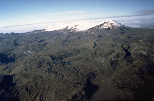
Romeral is a stratovolcano rising to 3,769 meters (12,366 feet) in Colombia's South America Volcanic Regions. The volcano is currently active, with its most recent eruption in 5390 BCE. The volcano has produced 2 recorded eruptions, with a maximum Volcanic Explosivity Index (VEI) of 4.
Geography & Climate
Romeral is located in Colombia, within the Northern Andean Volcanic Arc of the broader South America Volcanic Regions. Situated at 5.20° N, 75.36° W in the Northern Hemisphere, the volcano lies within a tropical climate zone. Standing at 3,769 meters above sea level, Romeral towers above the alpine zone, where vegetation gives way to bare rock, snow, and ice for much of the year. The high elevation means the upper slopes experience significantly colder temperatures than surrounding lowlands. The volcanic landform is characterized as a composite, which describes the physical shape and structure of the volcanic edifice as observed from the surface.
Geological Context
Romeral sits in a subduction zone, where one tectonic plate dives beneath another, creating intense heat and pressure that generates magma. Subduction zones are responsible for many of the world's most explosive volcanoes and deadliest eruptions. For communities in Colombia near Romeral, this tectonic setting means the volcano is capable of producing powerful explosive eruptions, pyroclastic flows, and lahars that can threaten populated areas within tens of kilometers of the summit. The dominant rock type is andesite / basaltic andesite, a dark, fine-grained volcanic rock that forms from rapidly cooling, low-viscosity lava. Basaltic eruptions tend to be less explosive and produce fluid lava flows that can travel long distances. While less immediately dangerous than explosive eruptions, basaltic lava flows can destroy structures and infrastructure in their path, and volcanic gases released during these eruptions can affect air quality over a wide area.
Eruption History Summary
Romeral has 2 recorded eruptions in the geological database, spanning from 6510 BCE to 5390 BCE. The most powerful recorded event was a cataclysmic eruption with ash columns reaching the stratosphere in 5390 BCE, reaching VEI 4 on the Volcanic Explosivity Index. Notable eruptions include 5390 BCE (VEI 4), 6510 BCE (VEI 4). These eruptions span roughly 1,120 years of volcanic history.
Significance
With a maximum recorded VEI of 4, Romeral has demonstrated the capacity for significant explosive eruptions that can impact regional aviation, agriculture, and communities tens of kilometers from the summit. VEI 4 eruptions produce ash columns reaching 15-25 kilometers into the atmosphere.
GVP Reference Summary
The andesitic-to-dacitic Romeral stratovolcano lies at the northern end of the Ruiz-Tolima volcanic chain, NW of Cerro Bravo volcano, and east of the towns of Neira and Aranzazu. It has produced two young Plinian pumice deposits covering areas to the NW. The pumice deposits are separated by a soil layer radiocarbon dated at about 8,460 and 7,340 years BP.
— Smithsonian Institution, Global Volcanism Program
2 Recorded Eruptions
| Year | VEI | Type | Area |
|---|---|---|---|
| 5390 BCE | 4 | Confirmed Eruption | — |
| 6510 BCE | 4 | Confirmed Eruption | — |
Real-Time Data
Frequently Asked Questions About Romeral
Is Romeral an active volcano?+
Romeral is not currently classified as active. Its activity evidence is listed as "Eruption Dated." The last known eruption was in 5390 BCE. However, no volcano is ever considered permanently extinct.
When did Romeral last erupt?+
The most recent recorded eruption of Romeral occurred in 5390 BCE with a Volcanic Explosivity Index (VEI) of 4. The eruption was classified as a "Confirmed Eruption." Romeral has 2 recorded eruptions in total.
How high is Romeral?+
Romeral has a summit elevation of 3,769 meters (12,366 feet) above sea level. At 3,769 meters, it is comparable in height to many significant mountain peaks and stands well above the tree line.
What type of volcano is Romeral?+
Romeral is classified as a Stratovolcano. Stratovolcanoes (also called composite volcanoes) are steep, conical volcanoes built up by many layers of hardened lava, tephra, and volcanic ash. They are among the most common and dangerous types, known for explosive eruptions.
Where is Romeral located?+
Romeral is located in Colombia, in the South America Volcanic Regions. More specifically, it lies within the Northern Andean Volcanic Arc. Its exact coordinates are 5.203° latitude, -75.363° longitude.
Is it safe to visit Romeral?+
Romeral can generally be visited, but as with any volcano, visitors should check local conditions and any advisory notices before traveling. Colombia may have specific regulations for accessing volcanic areas. Guided tours are often the safest and most informative way to experience a volcano.