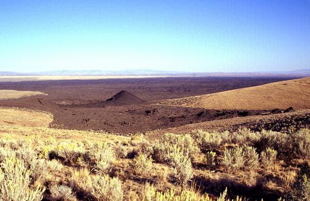
Black Butte Crater Lava Field
Shield · 1,478m · United States
About Black Butte Crater Lava Field
Black Butte Crater Lava Field is a shield rising to 1,478 meters (4,849 feet) in United States's North America Volcanic Regions. The volcano is currently active, with its most recent eruption in 8180 BCE. The volcano has produced 1 recorded eruption.
Geography & Climate
Black Butte Crater Lava Field is located in United States, within the Yellowstone-Snake River Hotspot Volcano Group of the broader North America Volcanic Regions. Situated at 43.18° N, 114.35° W in the Northern Hemisphere, the volcano lies within a temperate climate zone. With a summit elevation of 1,478 meters above sea level, Black Butte Crater Lava Field is a moderately sized peak that remains accessible to hikers and researchers for much of the year. The volcanic landform is characterized as a shield, which describes the physical shape and structure of the volcanic edifice as observed from the surface.
Geological Context
Black Butte Crater Lava Field is situated along a rift zone, where tectonic plates are pulling apart. As the crust thins and fractures, magma rises to fill the gap, creating volcanic activity. Rift volcanism typically produces more fluid lava flows rather than explosive blasts, which means communities near Black Butte Crater Lava Field in United States generally face slower-moving hazards like lava flows and ground fissures rather than sudden pyroclastic events. However, rift volcanoes can still generate significant ash emissions and gas releases that affect local air quality. The dominant rock type is basalt / picro-basalt, a dark, fine-grained volcanic rock that forms from rapidly cooling, low-viscosity lava. Basaltic eruptions tend to be less explosive and produce fluid lava flows that can travel long distances. While less immediately dangerous than explosive eruptions, basaltic lava flows can destroy structures and infrastructure in their path, and volcanic gases released during these eruptions can affect air quality over a wide area.
Eruption History Summary
Black Butte Crater Lava Field has 1 recorded eruption in the geological database, spanning from 8180 BCE to 8180 BCE.
GVP Reference Summary
The Black Butte Crater lava field is the westernmost of the young lava fields of the Eastern Snake River Plain. It lies north of Twin Falls, Idaho, and created an L-shaped lava flow 2-5 km wide that extends 60 km S and then west. A single radiocarbon age of 10,130 +/- 350 years BP was obtained for lava flows here (Kuntz et al., 1986). Black Butte Crater caps a lava shield at the NE end of the flow field. The vent area contains a complex lava lake that forms a six-part flower-petal like depression with steep walls up to 30 m high that covers an area of 2 km2. A lava tube and channel system extending 5 km SE of the crater displays both roofed and collapsed portions. The Big Wood and Little Wood rivers follow the northern and southern margins of the distal part of the lava flow, respectively. The voluminous flow diverted the river channels so that they now join 40 km W of their former confluence.
— Smithsonian Institution, Global Volcanism Program
1 Recorded Eruption
| Year | VEI | Type | Area |
|---|---|---|---|
| 8180 BCE | 0 | Confirmed Eruption | Black Butte Crater |
Real-Time Data
Frequently Asked Questions About Black Butte Crater Lava Field
Is Black Butte Crater Lava Field an active volcano?+
Black Butte Crater Lava Field is not currently classified as active. Its activity evidence is listed as "Eruption Dated." The last known eruption was in 8180 BCE. However, no volcano is ever considered permanently extinct.
When did Black Butte Crater Lava Field last erupt?+
The most recent recorded eruption of Black Butte Crater Lava Field occurred in 8180 BCE with a Volcanic Explosivity Index (VEI) of 0. The eruption was classified as a "Confirmed Eruption." Black Butte Crater Lava Field has 1 recorded eruption in total.
How high is Black Butte Crater Lava Field?+
Black Butte Crater Lava Field has a summit elevation of 1,478 meters (4,849 feet) above sea level. At 1,478 meters, it is a moderately sized volcanic peak, roughly comparable to Mount Vesuvius (1,281m).
What type of volcano is Black Butte Crater Lava Field?+
Black Butte Crater Lava Field is classified as a Shield. Shield volcanoes have distinct geological characteristics that set them apart from other volcanic types.
Where is Black Butte Crater Lava Field located?+
Black Butte Crater Lava Field is located in United States, in the North America Volcanic Regions. More specifically, it lies within the Yellowstone-Snake River Hotspot Volcano Group. Its exact coordinates are 43.183° latitude, -114.352° longitude.
Is it safe to visit Black Butte Crater Lava Field?+
Black Butte Crater Lava Field can generally be visited, but as with any volcano, visitors should check local conditions and any advisory notices before traveling. United States may have specific regulations for accessing volcanic areas. Guided tours are often the safest and most informative way to experience a volcano.