Kuril Arc at 46.3°N
· -100m · Japan - administered by Russia
About Kuril Arc at 46.3°N
Kuril Arc at 46.3°N is a rising to -100 meters (-328 feet) in Japan - administered by Russia's Northwestern Pacific Volcanic Regions. No historical eruptions have been recorded, though the volcano is classified based on geological evidence of past activity. The volcano has produced 2 recorded eruptions.
Geography & Climate
Kuril Arc at 46.3°N is located in Japan - administered by Russia, within the Kuril Volcanic Arc of the broader Northwestern Pacific Volcanic Regions. Situated at 46.29° N, 150.85° E in the Northern Hemisphere, the volcano lies within a temperate climate zone. With an elevation of -100 meters — below sea level — Kuril Arc at 46.3°N is a submarine or submerged volcanic feature. Submarine volcanoes make up the majority of Earth's volcanic activity, though most eruptions go unobserved beneath the ocean surface. The volcanic landform is characterized as a composite, which describes the physical shape and structure of the volcanic edifice as observed from the surface.
Geological Context
Kuril Arc at 46.3°N sits in a subduction zone, where one tectonic plate dives beneath another, creating intense heat and pressure that generates magma. Subduction zones are responsible for many of the world's most explosive volcanoes and deadliest eruptions. For communities in Japan - administered by Russia near Kuril Arc at 46.3°N, this tectonic setting means the volcano is capable of producing powerful explosive eruptions, pyroclastic flows, and lahars that can threaten populated areas within tens of kilometers of the summit. The dominant rock type is no data (checked), which influences the viscosity of the magma and, consequently, the style of eruptions this volcano produces. Rock chemistry is one of the most important factors in determining whether a volcano erupts explosively or effusively.
Eruption History Summary
Kuril Arc at 46.3°N has 2 recorded eruptions in the geological database, spanning from 1972 CE to 1978 CE. These eruptions span roughly 6 years of volcanic history. The most recent eruption in 1978 CE places this volcano within the modern era of volcanological observation.
GVP Reference Summary
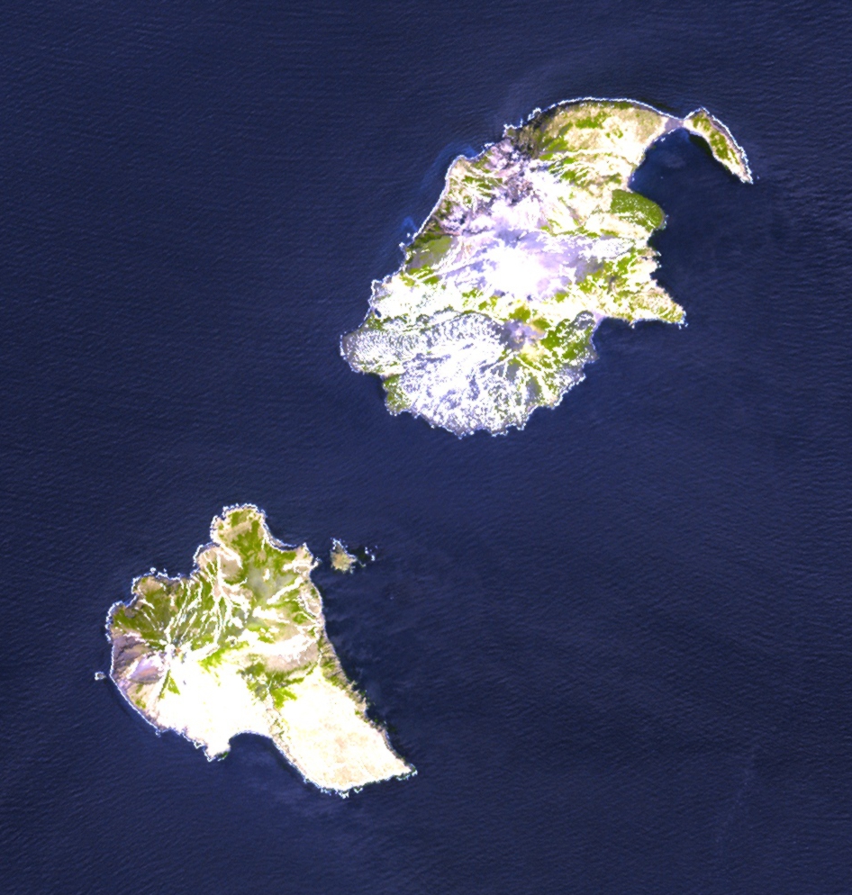
A shallow flat-topped edifice ~8 km in diameter, with depths from 0-50 m, is located in the Urup Strait ~15 km S of the Chernyye Brat'ya (Black Brothers) islands and ~20 km ENE of Urup Island in the Kuril Islands. Although visible using satellite bathymetry and appearing simply as a shallow platform on a map in Blokh et al. (2019) rather than a previously identified volcanic seamount, there is no available research about this edifice. Two reports of uncertain volcanic activity are assigned to this feature. This volcano number was previously created and placed at a location 7.5 km SE of the coast of Urup (~35 km SW), due to reported bubbling water seen from a fishing boat in March 1978 (SEAN 03:05), but was removed from the catalog due to insufficient evidence of any volcanic features. Hydrophones signals detected in April 1972 were interpreted to be from a submarine eruption in the Kuriles, probably between Simushir and Urup Island (Smithsonian CSLP 33-72). This activity was previously arbitrarily linked to Arkhangelsky, the submarine feature most centrally located between Urup and Simushir Islands, but has been reassigned following research showing a Pleistocene age for that massif.
— Smithsonian Institution, Global Volcanism Program
2 Recorded Eruptions
| Year | VEI | Type | Area |
|---|---|---|---|
| 1978 | 0 | Uncertain Eruption | 7.7 km E of Urup Island |
| 1972 | 0 | Uncertain Eruption | — |
Real-Time Data
Frequently Asked Questions About Kuril Arc at 46.3°N
Is Kuril Arc at 46.3°N an active volcano?+
Kuril Arc at 46.3°N is not currently classified as active. Its activity evidence is listed as "Evidence Uncertain." No recorded eruptions have been documented. However, no volcano is ever considered permanently extinct.
When did Kuril Arc at 46.3°N last erupt?+
The most recent recorded eruption of Kuril Arc at 46.3°N occurred in 1978 CE with a Volcanic Explosivity Index (VEI) of 0. The eruption was classified as a "Uncertain Eruption." Kuril Arc at 46.3°N has 2 recorded eruptions in total.
How high is Kuril Arc at 46.3°N?+
Kuril Arc at 46.3°N has a summit elevation of -100 meters (-328 feet) above sea level. With an elevation of -100 meters (below sea level), this is a submarine or submerged volcanic feature.
What type of volcano is Kuril Arc at 46.3°N?+
Kuril Arc at 46.3°N is classified as a . volcanoes have distinct geological characteristics that set them apart from other volcanic types.
Where is Kuril Arc at 46.3°N located?+
Kuril Arc at 46.3°N is located in Japan - administered by Russia, in the Northwestern Pacific Volcanic Regions. More specifically, it lies within the Kuril Volcanic Arc. Its exact coordinates are 46.294° latitude, 150.853° longitude.
Is it safe to visit Kuril Arc at 46.3°N?+
Kuril Arc at 46.3°N can generally be visited, but as with any volcano, visitors should check local conditions and any advisory notices before traveling. Japan - administered by Russia may have specific regulations for accessing volcanic areas. Guided tours are often the safest and most informative way to experience a volcano.