About Bristol Island
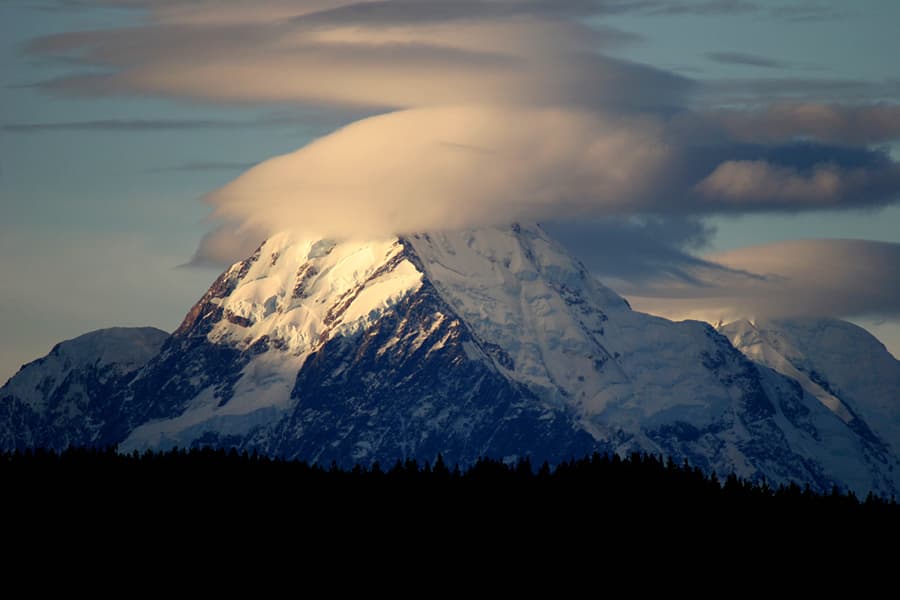
Bristol Island is a stratovolcano rising to 1,100 meters (3,609 feet) in United Kingdom's Antarctic-Scotia Volcanic Regions. It has been active in recent decades, with its last eruption in 2016 CE. The volcano has produced 6 recorded eruptions, with a maximum Volcanic Explosivity Index (VEI) of 3.
Geography & Climate
Bristol Island is located in United Kingdom, within the South Sandwich Volcanic Arc of the broader Antarctic-Scotia Volcanic Regions. Situated at 59.02° S, 26.53° W in the Southern Hemisphere, the volcano lies within a subarctic climate zone. With a summit elevation of 1,100 meters above sea level, Bristol Island is a moderately sized peak that remains accessible to hikers and researchers for much of the year. The volcanic landform is characterized as a composite, which describes the physical shape and structure of the volcanic edifice as observed from the surface.
Geological Context
Bristol Island sits in a subduction zone, where one tectonic plate dives beneath another, creating intense heat and pressure that generates magma. Subduction zones are responsible for many of the world's most explosive volcanoes and deadliest eruptions. For communities in United Kingdom near Bristol Island, this tectonic setting means the volcano is capable of producing powerful explosive eruptions, pyroclastic flows, and lahars that can threaten populated areas within tens of kilometers of the summit. The dominant rock type is basalt / picro-basalt, a dark, fine-grained volcanic rock that forms from rapidly cooling, low-viscosity lava. Basaltic eruptions tend to be less explosive and produce fluid lava flows that can travel long distances. While less immediately dangerous than explosive eruptions, basaltic lava flows can destroy structures and infrastructure in their path, and volcanic gases released during these eruptions can affect air quality over a wide area.
Eruption History Summary
Bristol Island has 6 recorded eruptions in the geological database, spanning from 1823 CE to 2016 CE. The most powerful recorded event was a severe eruption capable of regional ash fall and pyroclastic flows in 1956 CE, reaching VEI 3 on the Volcanic Explosivity Index. This eruption frequency indicates a moderately active volcanic system with periodic reawakenings. With eruptive activity as recently as 2016 CE, Bristol Island remains an actively monitored volcano.
Significance
With a maximum recorded VEI of 3, Bristol Island has produced eruptions capable of generating pyroclastic flows and significant ash fall in the surrounding area. While not among the largest eruptions globally, VEI 3 events pose serious hazards to local populations and can disrupt regional air travel. With 6 recorded eruptions on file, Bristol Island has enough documented activity to help scientists identify patterns in its eruptive behavior. Given its recent activity, Bristol Island is closely monitored by geological survey organizations to provide early warning of future unrest.
GVP Reference Summary
The 9 x 10 km Bristol Island near the southern end of the South Sandwich arc lies across Fortser's Passage from the Southern Thule Islands and forms one of the largest islands of the chain. Largely glacier-covered, it contains a horseshoe-shaped ridge at the interior extending northward from the highest peak, 1100-m-high Mount Darnley. A steep-sided flank cone or lava dome, Havfruen Peak, is located on the east side, and a young crater and fissure are on the west flank. Three large sea stacks lying off Turmoil Point at the western tip of the island may be remnants of an older now-eroded volcanic center. Both summit and flank vents have been active during historical time. The latest eruption, during 1956, originated from the west-flank crater, and deposited cinder over the icecap. The extensive icecap and the difficulty of landing make it the least explored of the South Sandwich Islands.
— Smithsonian Institution, Global Volcanism Program
6 Recorded Eruptions
| Year | VEI | Type | Area |
|---|---|---|---|
| 2016 | 1 | Confirmed Eruption | Main crater, Mt. Sourabaya |
| 1956 | 3 | Confirmed Eruption | West flank |
| 1950 | 2 | Confirmed Eruption | — |
| 1936 | 2 | Confirmed Eruption | — |
| 1935 | 2 | Confirmed Eruption | — |
| 1823 | 2 | Confirmed Eruption | — |
Real-Time Data
Frequently Asked Questions About Bristol Island
Is Bristol Island an active volcano?+
Yes, Bristol Island is considered an active volcano. Its most recent eruption was in 2016 CE. The volcano is monitored by geological agencies, and its activity status is based on observed eruptions within recorded history.
When did Bristol Island last erupt?+
The most recent recorded eruption of Bristol Island occurred in 2016 CE with a Volcanic Explosivity Index (VEI) of 1. The eruption was classified as a "Confirmed Eruption." Bristol Island has 6 recorded eruptions in total.
How high is Bristol Island?+
Bristol Island has a summit elevation of 1,100 meters (3,609 feet) above sea level. At 1,100 meters, it is a moderately sized volcanic peak, roughly comparable to Mount Vesuvius (1,281m).
What type of volcano is Bristol Island?+
Bristol Island is classified as a Stratovolcano. Stratovolcanoes (also called composite volcanoes) are steep, conical volcanoes built up by many layers of hardened lava, tephra, and volcanic ash. They are among the most common and dangerous types, known for explosive eruptions.
Where is Bristol Island located?+
Bristol Island is located in United Kingdom, in the Antarctic-Scotia Volcanic Regions. More specifically, it lies within the South Sandwich Volcanic Arc. Its exact coordinates are -59.017° latitude, -26.533° longitude.
Is it safe to visit Bristol Island?+
Visiting Bristol Island requires checking current volcanic activity and alert levels. As an active volcano with eruptions as recent as 2016 CE, conditions can change rapidly. Always consult local geological authorities and follow official warnings before visiting. Many active volcanoes have designated safe viewing areas and guided tour options.