About Terceira
Terceira is a stratovolcano(es) rising to 1,023 meters (3,356 feet) in Portugal's Atlantic Ocean Volcanic Regions. It has been active in recent decades, with its last eruption in 2000 CE. The volcano has produced 15 recorded eruptions, with a maximum Volcanic Explosivity Index (VEI) of 3.
Geography & Climate
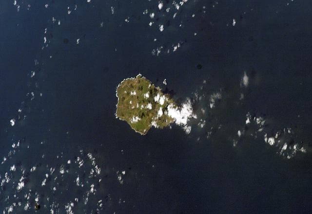
Terceira is located in Portugal, within the Azores-Terceira Rift Volcanic Province of the broader Atlantic Ocean Volcanic Regions. Situated at 38.73° N, 27.32° W in the Northern Hemisphere, the volcano lies within a temperate climate zone. With a summit elevation of 1,023 meters above sea level, Terceira is a moderately sized peak that remains accessible to hikers and researchers for much of the year. The volcanic landform is characterized as a composite, which describes the physical shape and structure of the volcanic edifice as observed from the surface.
Geological Context
Terceira is situated along a rift zone, where tectonic plates are pulling apart. As the crust thins and fractures, magma rises to fill the gap, creating volcanic activity. Rift volcanism typically produces more fluid lava flows rather than explosive blasts, which means communities near Terceira in Portugal generally face slower-moving hazards like lava flows and ground fissures rather than sudden pyroclastic events. However, rift volcanoes can still generate significant ash emissions and gas releases that affect local air quality. The dominant rock type is basalt / picro-basalt, a dark, fine-grained volcanic rock that forms from rapidly cooling, low-viscosity lava. Basaltic eruptions tend to be less explosive and produce fluid lava flows that can travel long distances. While less immediately dangerous than explosive eruptions, basaltic lava flows can destroy structures and infrastructure in their path, and volcanic gases released during these eruptions can affect air quality over a wide area.
Eruption History Summary
Terceira has 15 recorded eruptions in the geological database, spanning from 6720 BCE to 1998 CE. The most powerful recorded event was a severe eruption capable of regional ash fall and pyroclastic flows in 1867 CE, reaching VEI 3 on the Volcanic Explosivity Index. This level of eruptive frequency indicates a persistently active volcanic system that warrants ongoing monitoring. The most recent eruption in 1998 CE places this volcano within the modern era of volcanological observation.
Significance
With a maximum recorded VEI of 3, Terceira has produced eruptions capable of generating pyroclastic flows and significant ash fall in the surrounding area. While not among the largest eruptions globally, VEI 3 events pose serious hazards to local populations and can disrupt regional air travel. With 15 recorded eruptions, Terceira has a substantial eruptive history that provides valuable data for understanding volcanic behavior and assessing future hazards in the Atlantic Ocean Volcanic Regions region. Given its recent activity, Terceira is closely monitored by geological survey organizations to provide early warning of future unrest.
GVP Reference Summary
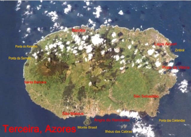
Terceira Island contains multiple stratovolcanoes constructed along a prominent ESE-WNW fissure zone that cuts across the island. Historically active Santa Barbara volcano at the western end of the island is truncated by two calderas, the youngest of which formed about 15,000 years ago. Comenditic lava domes fill and surround the caldera. Pico Alto lies north of the fissure zone in the north-central part of the island and contains a Pleistocene caldera largely filled by lava domes and lava flows. Guilherme Moniz caldera lies along the fissure zone immediately to the south, and 7-km-wide Cinquio Picos caldera is at the SE end of the island. Historical eruptions have occurred from Pico Alto, the fissure zone between Pico Alto and Santa Barbara, and from submarine vents west of Santa Barbara. Most Holocene eruptions have produced basaltic-to-rhyolitic lava flows from the fissure zone.
— Smithsonian Institution, Global Volcanism Program
15 Recorded Eruptions
| Year | VEI | Type | Area |
|---|---|---|---|
| 1998 | 0 | Confirmed Eruption | Serreta Ridge (submarine vent W of Terceira) |
| 1867 | 3 | Confirmed Eruption | Submarine vent 3-6 WNW of Terceira |
| 1761 | 2 | Confirmed Eruption | Fissure zone (east of Santa Barbara) |
| 1400 | — | Confirmed Eruption | Farol I dome (Santa Barbara) |
| 1200 | — | Confirmed Eruption | Guilherme Moniz (Pico Alto) |
| 920 | — | Confirmed Eruption | Guilherme Moniz (Quinta da Madalena) |
| 820 | — | Confirmed Eruption | Santa Barbara |
| 190 | — | Confirmed Eruption | Guilherme Moniz (Pico Alto) |
| 70 | — | Confirmed Eruption | Fissure zone (east of Santa Barbara) |
| 60 BCE | — | Confirmed Eruption | Fissure zone (south of Pico Alto) |
| 90 BCE | — | Confirmed Eruption | Fissure zone (east of Santa Barbara) |
| 670 BCE | — | Confirmed Eruption | Guilherme Moniz |
| 940 BCE | — | Confirmed Eruption | Santa Barbara NW flank (Lagoinha dome) |
| 2530 BCE | — | Confirmed Eruption | Fissure zone (east of Santa Barbara) |
| 6720 BCE | — | Confirmed Eruption | Guilherme Moniz (Pico das Pardelas) |
Real-Time Data
Frequently Asked Questions About Terceira
Is Terceira an active volcano?+
Yes, Terceira is considered an active volcano. Its most recent eruption was in 2000 CE. The volcano is monitored by geological agencies, and its activity status is based on observed eruptions within recorded history.
When did Terceira last erupt?+
The most recent recorded eruption of Terceira occurred in 1998 CE with a Volcanic Explosivity Index (VEI) of 0. The eruption was classified as a "Confirmed Eruption." Terceira has 15 recorded eruptions in total.
How high is Terceira?+
Terceira has a summit elevation of 1,023 meters (3,356 feet) above sea level. At 1,023 meters, it is a moderately sized volcanic peak, roughly comparable to Mount Vesuvius (1,281m).
What type of volcano is Terceira?+
Terceira is classified as a Stratovolcano(es). Stratovolcano(es) volcanoes have distinct geological characteristics that set them apart from other volcanic types.
Where is Terceira located?+
Terceira is located in Portugal, in the Atlantic Ocean Volcanic Regions. More specifically, it lies within the Azores-Terceira Rift Volcanic Province. Its exact coordinates are 38.730° latitude, -27.320° longitude.
Is it safe to visit Terceira?+
Visiting Terceira requires checking current volcanic activity and alert levels. As an active volcano with eruptions as recent as 2000 CE, conditions can change rapidly. Always consult local geological authorities and follow official warnings before visiting. Many active volcanoes have designated safe viewing areas and guided tour options.