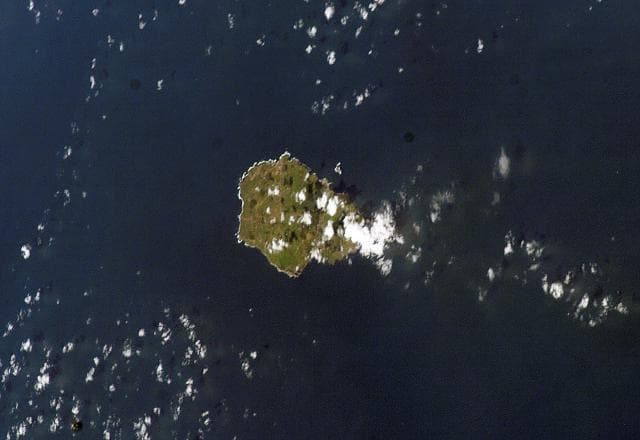
About Pico
Pico is a stratovolcano rising to 2,351 meters (7,714 feet) in Portugal's Atlantic Ocean Volcanic Regions. Its last known eruption was in 1720 CE. The volcano has produced 4 recorded eruptions, with a maximum Volcanic Explosivity Index (VEI) of 2.
Geography & Climate
Pico is located in Portugal, within the Azores-Terceira Rift Volcanic Province of the broader Atlantic Ocean Volcanic Regions. Situated at 38.47° N, 28.40° W in the Northern Hemisphere, the volcano lies within a temperate climate zone. At 2,351 meters above sea level, Pico rises above the surrounding terrain into montane or subalpine conditions. The elevation creates distinct ecological zones along its flanks, from forested lower slopes to exposed rocky terrain near the summit. The volcanic landform is characterized as a composite, which describes the physical shape and structure of the volcanic edifice as observed from the surface.
Geological Context
Pico is situated along a rift zone, where tectonic plates are pulling apart. As the crust thins and fractures, magma rises to fill the gap, creating volcanic activity. Rift volcanism typically produces more fluid lava flows rather than explosive blasts, which means communities near Pico in Portugal generally face slower-moving hazards like lava flows and ground fissures rather than sudden pyroclastic events. However, rift volcanoes can still generate significant ash emissions and gas releases that affect local air quality. The dominant rock type is basalt / picro-basalt, a dark, fine-grained volcanic rock that forms from rapidly cooling, low-viscosity lava. Basaltic eruptions tend to be less explosive and produce fluid lava flows that can travel long distances. While less immediately dangerous than explosive eruptions, basaltic lava flows can destroy structures and infrastructure in their path, and volcanic gases released during these eruptions can affect air quality over a wide area.
Eruption History Summary
Pico has 4 recorded eruptions in the geological database, spanning from 1562 CE to 1963 CE. The most powerful recorded event was an explosive event producing ash plumes up to several kilometers in 1720 CE, reaching VEI 2 on the Volcanic Explosivity Index. These eruptions span roughly 401 years of volcanic history. The most recent eruption in 1963 CE places this volcano within the modern era of volcanological observation.
GVP Reference Summary
The conical Pico stratovolcano occupies the western end of Pico Island and is the highest volcano in the Azores. The dominantly basaltic edifice lies west of on an older linear volcano with numerous flank cones that forms most of the 46-km-long island. It was constructed over the Montanha volcanic complex on the eastern side of the island and is capped by a 500-m-wide summit crater that is overtopped by a small steep-sided cone. An eruption beginning in 1562 from the Sao Roque Piedade/Planalto da Achada fissure zone produced lava flows that reached the northern coast. Two fissures erupted on the NNW flank and SE flank of Pico volcano in 1718, with lavas reaching the north and south coasts. Lava flows from a fissure on the SE flank in 1720 reached the ocean.
— Smithsonian Institution, Global Volcanism Program
4 Recorded Eruptions
| Year | VEI | Type | Area |
|---|---|---|---|
| 1963 | 0 | Uncertain Eruption | Off NW coast |
| 1720 | 2 | Confirmed Eruption | SE flank (400 m) |
| 1718 | 2 | Confirmed Eruption | SE flank (200 m), NW flank (1200 m) |
| 1562 | 2 | Confirmed Eruption | East flank (800 m) |
Real-Time Data
Frequently Asked Questions About Pico
Is Pico an active volcano?+
Pico is classified as active based on credible evidence of past eruptions. Although its last known eruption was in 1720 CE, volcanologists consider it capable of erupting again.
When did Pico last erupt?+
The most recent recorded eruption of Pico occurred in 1963 CE with a Volcanic Explosivity Index (VEI) of 0. The eruption was classified as a "Uncertain Eruption." Pico has 4 recorded eruptions in total.
How high is Pico?+
Pico has a summit elevation of 2,351 meters (7,714 feet) above sea level. At 2,351 meters, it is comparable in height to many significant mountain peaks and stands well above the tree line.
What type of volcano is Pico?+
Pico is classified as a Stratovolcano. Stratovolcanoes (also called composite volcanoes) are steep, conical volcanoes built up by many layers of hardened lava, tephra, and volcanic ash. They are among the most common and dangerous types, known for explosive eruptions.
Where is Pico located?+
Pico is located in Portugal, in the Atlantic Ocean Volcanic Regions. More specifically, it lies within the Azores-Terceira Rift Volcanic Province. Its exact coordinates are 38.470° latitude, -28.400° longitude.
Is it safe to visit Pico?+
Pico can generally be visited, but as with any volcano, visitors should check local conditions and any advisory notices before traveling. Portugal may have specific regulations for accessing volcanic areas. Guided tours are often the safest and most informative way to experience a volcano.