About Michinmahuida
Michinmahuida is a stratovolcano rising to 2,452 meters (8,045 feet) in Chile's South America Volcanic Regions. Its last known eruption was in 1835 CE. The volcano has produced 10 recorded eruptions, with a maximum Volcanic Explosivity Index (VEI) of 6.
Geography & Climate
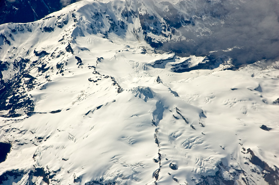
Michinmahuida is located in Chile, within the Southern Andean Volcanic Arc of the broader South America Volcanic Regions. Situated at 42.80° S, 72.44° W in the Southern Hemisphere, the volcano lies within a temperate climate zone. At 2,452 meters above sea level, Michinmahuida rises above the surrounding terrain into montane or subalpine conditions. The elevation creates distinct ecological zones along its flanks, from forested lower slopes to exposed rocky terrain near the summit. The volcanic landform is characterized as a composite, which describes the physical shape and structure of the volcanic edifice as observed from the surface.
Geological Context
Michinmahuida sits in a subduction zone, where one tectonic plate dives beneath another, creating intense heat and pressure that generates magma. Subduction zones are responsible for many of the world's most explosive volcanoes and deadliest eruptions. For communities in Chile near Michinmahuida, this tectonic setting means the volcano is capable of producing powerful explosive eruptions, pyroclastic flows, and lahars that can threaten populated areas within tens of kilometers of the summit. The dominant rock type is andesite / basaltic andesite, a dark, fine-grained volcanic rock that forms from rapidly cooling, low-viscosity lava. Basaltic eruptions tend to be less explosive and produce fluid lava flows that can travel long distances. While less immediately dangerous than explosive eruptions, basaltic lava flows can destroy structures and infrastructure in their path, and volcanic gases released during these eruptions can affect air quality over a wide area.
Eruption History Summary
Michinmahuida has 10 recorded eruptions in the geological database, spanning from 8400 BCE to 1915 CE. The most powerful recorded event was a colossal eruption capable of affecting global climate for years in 8400 BCE, reaching VEI 6 on the Volcanic Explosivity Index. Notable eruptions include 1550 CE (VEI 4), 5500 BCE (VEI 5), 8400 BCE (VEI 6). This level of eruptive frequency indicates a persistently active volcanic system that warrants ongoing monitoring. The most recent eruption in 1915 CE places this volcano within the modern era of volcanological observation.
Significance
Michinmahuida has produced at least one eruption of VEI 6 or higher, placing it among the most powerful volcanic systems on Earth. Eruptions of this magnitude inject massive quantities of sulfur dioxide into the stratosphere, affecting global climate by lowering average temperatures for one to three years after the event. With 10 recorded eruptions, Michinmahuida has a substantial eruptive history that provides valuable data for understanding volcanic behavior and assessing future hazards in the South America Volcanic Regions region.
GVP Reference Summary
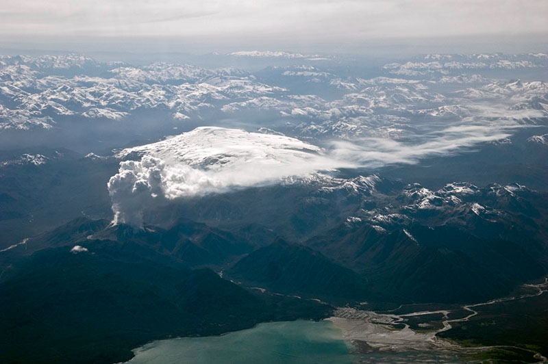
The glacier-covered basaltic-to-andesitic Volcán Michinmahuida, located west of Lago Reñihue, has a saddle-shaped summit with an elongated 3-km-wide caldera. The massive edifice is elongated in a NE-SW direction, and a youthful eruptive center is located on the ENE side of the complex. A major explosive eruption at the beginning of the Holocene produced the Amarillo Ignimbrite that may have created the now ice-filled summit caldera, and Holocene tephra deposits from summit and flank vents have been identified. An eruption was reported in 1742, and Charles Darwin observed activity in 1834. The latest known eruption, February-March 1835, produced a lava flow from a flank crater and lahars that reached the coast at Punta Chana.
— Smithsonian Institution, Global Volcanism Program
10 Recorded Eruptions
| Year | VEI | Type | Area |
|---|---|---|---|
| 1915 | 2 | Uncertain Eruption | — |
| 1835 | 0 | Confirmed Eruption | — |
| 1834 | 2 | Confirmed Eruption | — |
| 1775 | 2 | Uncertain Eruption | — |
| 1742 | 2 | Confirmed Eruption | — |
| 1650 | — | Uncertain Eruption | — |
| 1550 | 4 | Confirmed Eruption | — |
| 700 | — | Confirmed Eruption | — |
| 5500 BCE | 5 | Confirmed Eruption | — |
| 8400 BCE | 6 | Confirmed Eruption | — |
Real-Time Data
Frequently Asked Questions About Michinmahuida
Is Michinmahuida an active volcano?+
Michinmahuida is classified as active based on credible evidence of past eruptions. Although its last known eruption was in 1835 CE, volcanologists consider it capable of erupting again.
When did Michinmahuida last erupt?+
The most recent recorded eruption of Michinmahuida occurred in 1915 CE with a Volcanic Explosivity Index (VEI) of 2. The eruption was classified as a "Uncertain Eruption." Michinmahuida has 10 recorded eruptions in total.
How high is Michinmahuida?+
Michinmahuida has a summit elevation of 2,452 meters (8,045 feet) above sea level. At 2,452 meters, it is comparable in height to many significant mountain peaks and stands well above the tree line.
What type of volcano is Michinmahuida?+
Michinmahuida is classified as a Stratovolcano. Stratovolcanoes (also called composite volcanoes) are steep, conical volcanoes built up by many layers of hardened lava, tephra, and volcanic ash. They are among the most common and dangerous types, known for explosive eruptions.
Where is Michinmahuida located?+
Michinmahuida is located in Chile, in the South America Volcanic Regions. More specifically, it lies within the Southern Andean Volcanic Arc. Its exact coordinates are -42.799° latitude, -72.445° longitude.
Is it safe to visit Michinmahuida?+
Michinmahuida can generally be visited, but as with any volcano, visitors should check local conditions and any advisory notices before traveling. Chile may have specific regulations for accessing volcanic areas. Guided tours are often the safest and most informative way to experience a volcano.