About Longonot
Longonot is a stratovolcano rising to 2,776 meters (9,108 feet) in Kenya's Eastern Africa Volcanic Regions. Its last known eruption was in 1863 CE. The volcano has produced 3 recorded eruptions.
Geography & Climate
Longonot is located in Kenya, within the Kenyan Rift Volcanic Province of the broader Eastern Africa Volcanic Regions. Situated at 0.91° S, 36.45° E in the Southern Hemisphere, the volcano lies within a tropical climate zone. At 2,776 meters above sea level, Longonot rises above the surrounding terrain into montane or subalpine conditions. The elevation creates distinct ecological zones along its flanks, from forested lower slopes to exposed rocky terrain near the summit. The volcanic landform is characterized as a composite, which describes the physical shape and structure of the volcanic edifice as observed from the surface.
Geological Context
Longonot is situated along a rift zone, where tectonic plates are pulling apart. As the crust thins and fractures, magma rises to fill the gap, creating volcanic activity. Rift volcanism typically produces more fluid lava flows rather than explosive blasts, which means communities near Longonot in Kenya generally face slower-moving hazards like lava flows and ground fissures rather than sudden pyroclastic events. However, rift volcanoes can still generate significant ash emissions and gas releases that affect local air quality. The dominant rock type is trachyte / trachydacite, an intermediate to silica-rich volcanic rock. This composition typically produces more viscous magma, leading to more explosive eruptions with ash columns and pyroclastic flows. Andesitic and dacitic magmas build pressure before erupting, which is why volcanoes with this rock chemistry are often associated with Plinian-style eruptions that can send ash tens of kilometers into the atmosphere and disrupt aviation across entire regions.
Eruption History Summary
Longonot has 3 recorded eruptions in the geological database, spanning from 7200 BCE to 1863 CE. These eruptions span roughly 9,063 years of volcanic history.
GVP Reference Summary
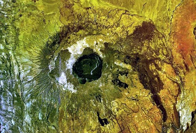
The trachytic Longonot stratovolcano SE of Lake Naivasha in the Gregory Rift valley contains a 8 x 12 km caldera. Formation of the caldera accompanied large explosive eruptions about 21,000 years ago. A large central cone that was constructed within the caldera, which forms the summit, is truncated by a circular, 1.8-km-wide crater. Post-caldera lavas are found on the caldera floor and the volcano's flanks, marking a late stage of effusive eruptions. A well-preserved satellitic cone is located on the NE flank. Masai tradition records a lava flow on the N flank during the 19th century. Similarly youthful-looking lava flows occur on the SW flank.
— Smithsonian Institution, Global Volcanism Program
3 Recorded Eruptions
| Year | VEI | Type | Area |
|---|---|---|---|
| 1863 | 0 | Confirmed Eruption | Northern flank |
| 1330 BCE | — | Confirmed Eruption | — |
| 7200 BCE | — | Confirmed Eruption | — |
Real-Time Data
Frequently Asked Questions About Longonot
Is Longonot an active volcano?+
Longonot is not currently classified as active. Its activity evidence is listed as "Eruption Dated." The last known eruption was in 1863 CE. However, no volcano is ever considered permanently extinct.
When did Longonot last erupt?+
The most recent recorded eruption of Longonot occurred in 1863 CE with a Volcanic Explosivity Index (VEI) of 0. The eruption was classified as a "Confirmed Eruption." Longonot has 3 recorded eruptions in total.
How high is Longonot?+
Longonot has a summit elevation of 2,776 meters (9,108 feet) above sea level. At 2,776 meters, it is comparable in height to many significant mountain peaks and stands well above the tree line.
What type of volcano is Longonot?+
Longonot is classified as a Stratovolcano. Stratovolcanoes (also called composite volcanoes) are steep, conical volcanoes built up by many layers of hardened lava, tephra, and volcanic ash. They are among the most common and dangerous types, known for explosive eruptions.
Where is Longonot located?+
Longonot is located in Kenya, in the Eastern Africa Volcanic Regions. More specifically, it lies within the Kenyan Rift Volcanic Province. Its exact coordinates are -0.914° latitude, 36.446° longitude.
Is it safe to visit Longonot?+
Longonot can generally be visited, but as with any volcano, visitors should check local conditions and any advisory notices before traveling. Kenya may have specific regulations for accessing volcanic areas. Guided tours are often the safest and most informative way to experience a volcano.