About Cumbal
Cumbal is a stratovolcano rising to 4,764 meters (15,631 feet) in Colombia's South America Volcanic Regions. It last erupted in 1926 CE, and volcanologists consider it an active volcanic system. The volcano has produced 2 recorded eruptions, with a maximum Volcanic Explosivity Index (VEI) of 2.
Geography & Climate
Cumbal is located in Colombia, within the Northern Andean Volcanic Arc of the broader South America Volcanic Regions. Situated at 0.95° N, 77.87° W in the Northern Hemisphere, the volcano lies within a tropical climate zone. Standing at 4,764 meters above sea level, Cumbal towers above the alpine zone, where vegetation gives way to bare rock, snow, and ice for much of the year. The high elevation means the upper slopes experience significantly colder temperatures than surrounding lowlands. The volcanic landform is characterized as a composite, which describes the physical shape and structure of the volcanic edifice as observed from the surface.
Geological Context
Cumbal sits in a subduction zone, where one tectonic plate dives beneath another, creating intense heat and pressure that generates magma. Subduction zones are responsible for many of the world's most explosive volcanoes and deadliest eruptions. For communities in Colombia near Cumbal, this tectonic setting means the volcano is capable of producing powerful explosive eruptions, pyroclastic flows, and lahars that can threaten populated areas within tens of kilometers of the summit. The dominant rock type is andesite / basaltic andesite, a dark, fine-grained volcanic rock that forms from rapidly cooling, low-viscosity lava. Basaltic eruptions tend to be less explosive and produce fluid lava flows that can travel long distances. While less immediately dangerous than explosive eruptions, basaltic lava flows can destroy structures and infrastructure in their path, and volcanic gases released during these eruptions can affect air quality over a wide area.
Eruption History Summary
Cumbal has 2 recorded eruptions in the geological database, spanning from 1877 CE to 1926 CE. The most powerful recorded event was an explosive event producing ash plumes up to several kilometers in 1926 CE, reaching VEI 2 on the Volcanic Explosivity Index. These eruptions span roughly 49 years of volcanic history. The most recent eruption in 1926 CE places this volcano within the modern era of volcanological observation.
GVP Reference Summary
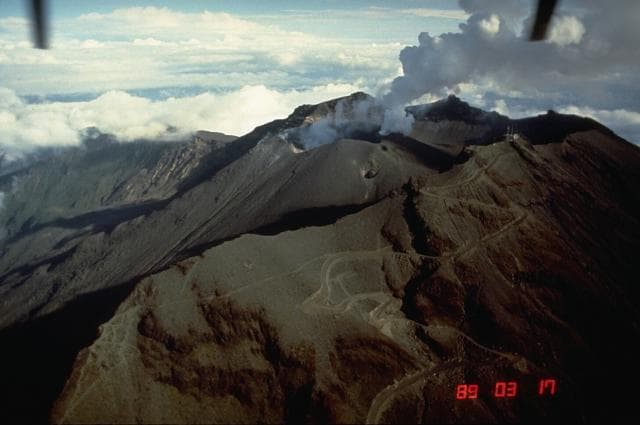
Many youthful lava flows extend from the glacier-capped Cumbal volcano, the southernmost historically active volcano of Colombia. The volcano is elongated in a NE-SW direction and is composed primarily of andesitic-dacitic lava flows. Two fumarolically active craters occupy the summit ridge: the main crater on the NE side and Mundo Nuevo crater on the SW. A young lava dome occupies the 250-m-wide summit crater, and eruptions from the upper E flank produced a 6-km-long lava field. The oldest crater lies NNE of the summit crater, suggesting SW-ward migration of activity. Explosive eruptions in 1877 and 1926 are the only known historical activity. Thermal springs are located on the SE flanks.
— Smithsonian Institution, Global Volcanism Program
2 Recorded Eruptions
| Year | VEI | Type | Area |
|---|---|---|---|
| 1926 | 2 | Confirmed Eruption | — |
| 1877 | 2 | Confirmed Eruption | — |
Real-Time Data
Frequently Asked Questions About Cumbal
Is Cumbal an active volcano?+
Yes, Cumbal is considered an active volcano. Its most recent eruption was in 1926 CE. The volcano is monitored by geological agencies, and its activity status is based on observed eruptions within recorded history.
When did Cumbal last erupt?+
The most recent recorded eruption of Cumbal occurred in 1926 CE with a Volcanic Explosivity Index (VEI) of 2. The eruption was classified as a "Confirmed Eruption." Cumbal has 2 recorded eruptions in total.
How high is Cumbal?+
Cumbal has a summit elevation of 4,764 meters (15,631 feet) above sea level. At 4,764 meters, it stands taller than Mount Rainier (4,392m) and is among the world's major volcanic peaks.
What type of volcano is Cumbal?+
Cumbal is classified as a Stratovolcano. Stratovolcanoes (also called composite volcanoes) are steep, conical volcanoes built up by many layers of hardened lava, tephra, and volcanic ash. They are among the most common and dangerous types, known for explosive eruptions.
Where is Cumbal located?+
Cumbal is located in Colombia, in the South America Volcanic Regions. More specifically, it lies within the Northern Andean Volcanic Arc. Its exact coordinates are 0.950° latitude, -77.870° longitude.
Is it safe to visit Cumbal?+
Visiting Cumbal requires checking current volcanic activity and alert levels. As an active volcano with eruptions as recent as 1926 CE, conditions can change rapidly. Always consult local geological authorities and follow official warnings before visiting. Many active volcanoes have designated safe viewing areas and guided tour options.