About Azufral
Azufral is a stratovolcano rising to 4,070 meters (13,354 feet) in Colombia's South America Volcanic Regions. Its last known eruption dates to 930 BCE, in prehistoric times. The volcano has produced 4 recorded eruptions, with a maximum Volcanic Explosivity Index (VEI) of 4.
Geography & Climate
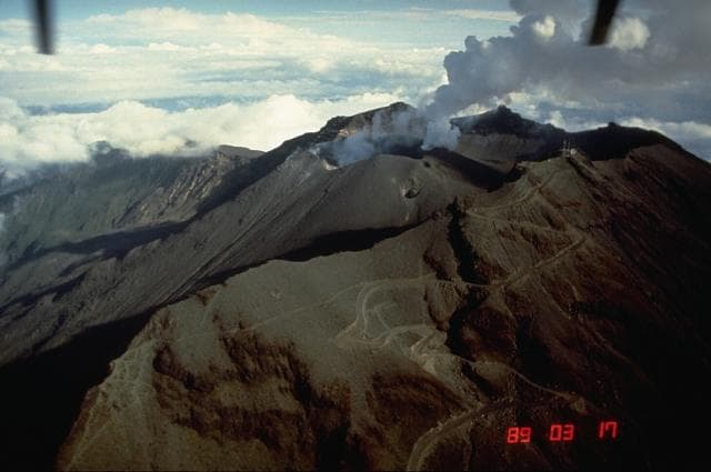
Azufral is located in Colombia, within the Northern Andean Volcanic Arc of the broader South America Volcanic Regions. Situated at 1.08° N, 77.68° W in the Northern Hemisphere, the volcano lies within a tropical climate zone. Standing at 4,070 meters above sea level, Azufral towers above the alpine zone, where vegetation gives way to bare rock, snow, and ice for much of the year. The high elevation means the upper slopes experience significantly colder temperatures than surrounding lowlands. The volcanic landform is characterized as a composite, which describes the physical shape and structure of the volcanic edifice as observed from the surface.
Geological Context
Azufral sits in a subduction zone, where one tectonic plate dives beneath another, creating intense heat and pressure that generates magma. Subduction zones are responsible for many of the world's most explosive volcanoes and deadliest eruptions. For communities in Colombia near Azufral, this tectonic setting means the volcano is capable of producing powerful explosive eruptions, pyroclastic flows, and lahars that can threaten populated areas within tens of kilometers of the summit. The dominant rock type is dacite, an intermediate to silica-rich volcanic rock. This composition typically produces more viscous magma, leading to more explosive eruptions with ash columns and pyroclastic flows. Andesitic and dacitic magmas build pressure before erupting, which is why volcanoes with this rock chemistry are often associated with Plinian-style eruptions that can send ash tens of kilometers into the atmosphere and disrupt aviation across entire regions.
Eruption History Summary
Azufral has 4 recorded eruptions in the geological database, spanning from 2095 BCE to 930 BCE. The most powerful recorded event was a cataclysmic eruption with ash columns reaching the stratosphere in 930 BCE, reaching VEI 4 on the Volcanic Explosivity Index. These eruptions span roughly 1,165 years of volcanic history.
Significance
With a maximum recorded VEI of 4, Azufral has demonstrated the capacity for significant explosive eruptions that can impact regional aviation, agriculture, and communities tens of kilometers from the summit. VEI 4 eruptions produce ash columns reaching 15-25 kilometers into the atmosphere.
GVP Reference Summary
Azufral stratovolcano in southern Colombia, also known as Azufral de Túquerres, is truncated by a 2.5 x 3 km caldera containing a Holocene rhyodacitic lava-dome complex. A crescent-shaped lake, Laguna Verde, occupies the NW side of the caldera. Nearly a dozen lava domes are present, the latest of which were formed about 3600 years ago and have active fumaroles. Azufral rocks are more silicic than those of nearby Colombian volcanoes; an apron of rhyodacitic pyroclastic-flow deposits rings the volcano. The last known eruption took place about 1000 years ago.
— Smithsonian Institution, Global Volcanism Program
4 Recorded Eruptions
| Year | VEI | Type | Area |
|---|---|---|---|
| 930 BCE | 4 | Confirmed Eruption | — |
| 1650 BCE | — | Confirmed Eruption | — |
| 1850 BCE | — | Confirmed Eruption | — |
| 2095 BCE | — | Confirmed Eruption | — |
Real-Time Data
Frequently Asked Questions About Azufral
Is Azufral an active volcano?+
Azufral is not currently classified as active. Its activity evidence is listed as "Eruption Dated." The last known eruption was in 930 BCE. However, no volcano is ever considered permanently extinct.
When did Azufral last erupt?+
The most recent recorded eruption of Azufral occurred in 930 BCE with a Volcanic Explosivity Index (VEI) of 4. The eruption was classified as a "Confirmed Eruption." Azufral has 4 recorded eruptions in total.
How high is Azufral?+
Azufral has a summit elevation of 4,070 meters (13,354 feet) above sea level. At 4,070 meters, it stands taller than Mount Rainier (4,392m) and is among the world's major volcanic peaks.
What type of volcano is Azufral?+
Azufral is classified as a Stratovolcano. Stratovolcanoes (also called composite volcanoes) are steep, conical volcanoes built up by many layers of hardened lava, tephra, and volcanic ash. They are among the most common and dangerous types, known for explosive eruptions.
Where is Azufral located?+
Azufral is located in Colombia, in the South America Volcanic Regions. More specifically, it lies within the Northern Andean Volcanic Arc. Its exact coordinates are 1.080° latitude, -77.680° longitude.
Is it safe to visit Azufral?+
Azufral can generally be visited, but as with any volcano, visitors should check local conditions and any advisory notices before traveling. Colombia may have specific regulations for accessing volcanic areas. Guided tours are often the safest and most informative way to experience a volcano.