About Cosiguina
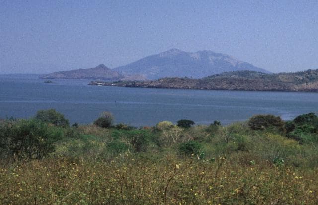
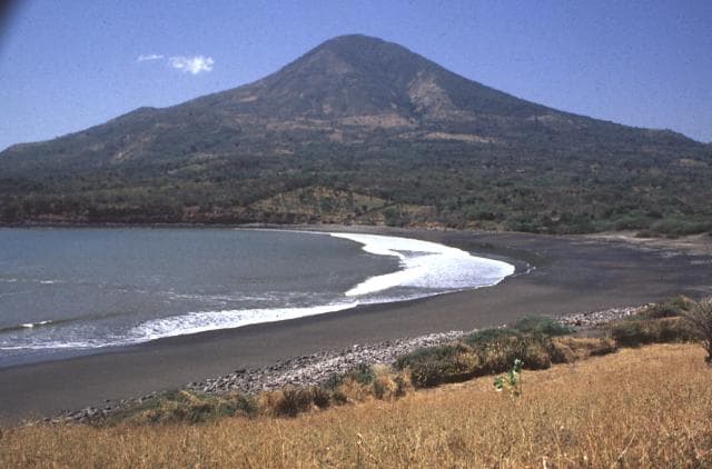
Cosiguina is a stratovolcano rising to 872 meters (2,861 feet) in Nicaragua's Middle America-Caribbean Volcanic Regions. Its last known eruption was in 1859 CE. The volcano has produced 7 recorded eruptions, with a maximum Volcanic Explosivity Index (VEI) of 5.
Geography & Climate
Cosiguina is located in Nicaragua, within the Central America Volcanic Arc of the broader Middle America-Caribbean Volcanic Regions. Situated at 12.98° N, 87.57° W in the Northern Hemisphere, the volcano lies within a tropical climate zone. With a summit elevation of 872 meters above sea level, Cosiguina is a moderately sized peak that remains accessible to hikers and researchers for much of the year. The volcanic landform is characterized as a composite, which describes the physical shape and structure of the volcanic edifice as observed from the surface.
Geological Context
Cosiguina sits in a subduction zone, where one tectonic plate dives beneath another, creating intense heat and pressure that generates magma. Subduction zones are responsible for many of the world's most explosive volcanoes and deadliest eruptions. For communities in Nicaragua near Cosiguina, this tectonic setting means the volcano is capable of producing powerful explosive eruptions, pyroclastic flows, and lahars that can threaten populated areas within tens of kilometers of the summit. The dominant rock type is andesite / basaltic andesite, a dark, fine-grained volcanic rock that forms from rapidly cooling, low-viscosity lava. Basaltic eruptions tend to be less explosive and produce fluid lava flows that can travel long distances. While less immediately dangerous than explosive eruptions, basaltic lava flows can destroy structures and infrastructure in their path, and volcanic gases released during these eruptions can affect air quality over a wide area.
Eruption History Summary
Cosiguina has 7 recorded eruptions in the geological database, spanning from 1500 CE to 1859 CE. The most powerful recorded event was a paroxysmal eruption with devastating regional consequences in 1835 CE, reaching VEI 5 on the Volcanic Explosivity Index. This eruption frequency indicates a moderately active volcanic system with periodic reawakenings.
Significance
With a maximum recorded VEI of 5, Cosiguina has demonstrated the capacity for paroxysmal eruptions comparable to the 1980 eruption of Mount St. Helens. Eruptions of this scale can devastate areas within 20-30 kilometers and produce ash fall that disrupts aviation and agriculture across hundreds of kilometers. With 7 recorded eruptions on file, Cosiguina has enough documented activity to help scientists identify patterns in its eruptive behavior.
GVP Reference Summary
Cosigüina (also spelled Cosegüina) is a low basaltic-to-andesitic composite volcano that is isolated from other eruptive centers in the Nicaraguan volcanic chain. The stratovolcano forms a large peninsula extending into the Gulf of Fonseca at the western tip of the country. It has a pronounced somma rim on the northern side; a young summit cone rises 300 m above the northern somma rim and buries the rim on other sides. The younger cone is truncated by a large elliptical prehistorical summit caldera, 2 x 2.4 km in diameter and 500 m deep, with a lake at its bottom. Lava flows predominate in the caldera walls, although lahar and pyroclastic-flow deposits surround the volcano. A brief but powerful explosive eruption in 1835 is Nicaragua's largest during historical time. Ash fell as far away as México, Costa Rica, and Jamaica, and pyroclastic flows reached the Gulf of Fonseca.
— Smithsonian Institution, Global Volcanism Program
7 Recorded Eruptions
| Year | VEI | Type | Area |
|---|---|---|---|
| 1859 | — | Confirmed Eruption | — |
| 1852 | 2 | Confirmed Eruption | — |
| 1835 | 5 | Confirmed Eruption | — |
| 1809 | 2 | Uncertain Eruption | — |
| 1709 | — | Confirmed Eruption | — |
| 1609 | — | Uncertain Eruption | — |
| 1500 | — | Confirmed Eruption | — |
Real-Time Data
Frequently Asked Questions About Cosiguina
Is Cosiguina an active volcano?+
Cosiguina is classified as active based on credible evidence of past eruptions. Although its last known eruption was in 1859 CE, volcanologists consider it capable of erupting again.
When did Cosiguina last erupt?+
The most recent recorded eruption of Cosiguina occurred in 1859 CE. The eruption was classified as a "Confirmed Eruption." Cosiguina has 7 recorded eruptions in total.
How high is Cosiguina?+
Cosiguina has a summit elevation of 872 meters (2,861 feet) above sea level. At 872 meters, it is a relatively low-elevation volcano.
What type of volcano is Cosiguina?+
Cosiguina is classified as a Stratovolcano. Stratovolcanoes (also called composite volcanoes) are steep, conical volcanoes built up by many layers of hardened lava, tephra, and volcanic ash. They are among the most common and dangerous types, known for explosive eruptions.
Where is Cosiguina located?+
Cosiguina is located in Nicaragua, in the Middle America-Caribbean Volcanic Regions. More specifically, it lies within the Central America Volcanic Arc. Its exact coordinates are 12.980° latitude, -87.570° longitude.
Is it safe to visit Cosiguina?+
Cosiguina can generally be visited, but as with any volcano, visitors should check local conditions and any advisory notices before traveling. Nicaragua may have specific regulations for accessing volcanic areas. Guided tours are often the safest and most informative way to experience a volcano.