About Tecapa
Tecapa is a stratovolcano rising to 1,593 meters (5,227 feet) in El Salvador's Middle America-Caribbean Volcanic Regions. No historical eruptions have been recorded, though the volcano is classified based on geological evidence of past activity. The volcano has produced 1 recorded eruption.
Geography & Climate
Tecapa is located in El Salvador, within the Central America Volcanic Arc of the broader Middle America-Caribbean Volcanic Regions. Situated at 13.49° N, 88.50° W in the Northern Hemisphere, the volcano lies within a tropical climate zone. With a summit elevation of 1,593 meters above sea level, Tecapa is a moderately sized peak that remains accessible to hikers and researchers for much of the year. The volcanic landform is characterized as a composite, which describes the physical shape and structure of the volcanic edifice as observed from the surface.
Geological Context
Tecapa sits in a subduction zone, where one tectonic plate dives beneath another, creating intense heat and pressure that generates magma. Subduction zones are responsible for many of the world's most explosive volcanoes and deadliest eruptions. For communities in El Salvador near Tecapa, this tectonic setting means the volcano is capable of producing powerful explosive eruptions, pyroclastic flows, and lahars that can threaten populated areas within tens of kilometers of the summit. The dominant rock type is andesite / basaltic andesite, a dark, fine-grained volcanic rock that forms from rapidly cooling, low-viscosity lava. Basaltic eruptions tend to be less explosive and produce fluid lava flows that can travel long distances. While less immediately dangerous than explosive eruptions, basaltic lava flows can destroy structures and infrastructure in their path, and volcanic gases released during these eruptions can affect air quality over a wide area.
Eruption History Summary
Tecapa has 1 recorded eruption in the geological database, spanning from 1878 CE to 1878 CE.
GVP Reference Summary
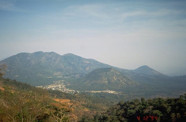
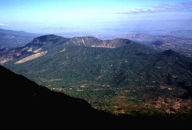
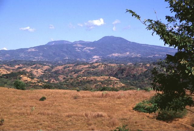
Tecapa is a complex basaltic-to-andesitic stratovolcano at the NW end of a cluster of volcanoes E of the Río Lempa between San Vicente and San Miguel volcanoes. The Berlín caldera, whose rim is visible on the W side of the complex, was formed during the eruption of the Blanca-Rosa dacitic pumice in the late Pleistocene. Following caldera formation, the cones of Cerro Las Palmas, Cerro Pelón, Tecapa-Laguna de Alegria, and Cerro Alegria were constructed along a WSW-ENE line. The crater of Tecapa-Laguna de Alegria contains a deep notch on the eastern rim and is filled by Laguna de Alegria crater lake. The volcanic complex currently displays fumarolic activity, and a producing geothermal plant is located at the Berlín geothermal field.
— Smithsonian Institution, Global Volcanism Program
1 Recorded Eruption
| Year | VEI | Type | Area |
|---|---|---|---|
| 1878 | — | Uncertain Eruption | — |
Real-Time Data
Frequently Asked Questions About Tecapa
Is Tecapa an active volcano?+
Tecapa is classified as active based on credible evidence of past eruptions. Although its last known eruption was in prehistoric times, volcanologists consider it capable of erupting again.
When did Tecapa last erupt?+
The most recent recorded eruption of Tecapa occurred in 1878 CE. The eruption was classified as a "Uncertain Eruption." Tecapa has 1 recorded eruption in total.
How high is Tecapa?+
Tecapa has a summit elevation of 1,593 meters (5,227 feet) above sea level. At 1,593 meters, it is a moderately sized volcanic peak, roughly comparable to Mount Vesuvius (1,281m).
What type of volcano is Tecapa?+
Tecapa is classified as a Stratovolcano. Stratovolcanoes (also called composite volcanoes) are steep, conical volcanoes built up by many layers of hardened lava, tephra, and volcanic ash. They are among the most common and dangerous types, known for explosive eruptions.
Where is Tecapa located?+
Tecapa is located in El Salvador, in the Middle America-Caribbean Volcanic Regions. More specifically, it lies within the Central America Volcanic Arc. Its exact coordinates are 13.494° latitude, -88.502° longitude.
Is it safe to visit Tecapa?+
Tecapa can generally be visited, but as with any volcano, visitors should check local conditions and any advisory notices before traveling. El Salvador may have specific regulations for accessing volcanic areas. Guided tours are often the safest and most informative way to experience a volcano.