San Francisco Volcanic Field
Volcanic field · 3,850m · United States
About San Francisco Volcanic Field
San Francisco Volcanic Field is a volcanic field rising to 3,850 meters (12,632 feet) in United States's North America Volcanic Regions. Its last known eruption was in 1075 CE. The volcano has produced 1 recorded eruption, with a maximum Volcanic Explosivity Index (VEI) of 4.
Geography & Climate
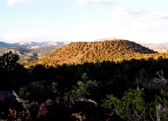
San Francisco Volcanic Field is located in United States, within the Basin and Range Volcanic Province of the broader North America Volcanic Regions. Situated at 35.35° N, 111.68° W in the Northern Hemisphere, the volcano lies within a temperate climate zone. Standing at 3,850 meters above sea level, San Francisco Volcanic Field towers above the alpine zone, where vegetation gives way to bare rock, snow, and ice for much of the year. The high elevation means the upper slopes experience significantly colder temperatures than surrounding lowlands. The volcanic landform is characterized as a cluster, which describes the physical shape and structure of the volcanic edifice as observed from the surface.
Geological Context
San Francisco Volcanic Field is situated along a rift zone, where tectonic plates are pulling apart. As the crust thins and fractures, magma rises to fill the gap, creating volcanic activity. Rift volcanism typically produces more fluid lava flows rather than explosive blasts, which means communities near San Francisco Volcanic Field in United States generally face slower-moving hazards like lava flows and ground fissures rather than sudden pyroclastic events. However, rift volcanoes can still generate significant ash emissions and gas releases that affect local air quality. The dominant rock type is basalt / picro-basalt, a dark, fine-grained volcanic rock that forms from rapidly cooling, low-viscosity lava. Basaltic eruptions tend to be less explosive and produce fluid lava flows that can travel long distances. While less immediately dangerous than explosive eruptions, basaltic lava flows can destroy structures and infrastructure in their path, and volcanic gases released during these eruptions can affect air quality over a wide area.
Eruption History Summary
San Francisco Volcanic Field has 1 recorded eruption in the geological database, spanning from 1075 CE to 1075 CE. The most powerful recorded event was a cataclysmic eruption with ash columns reaching the stratosphere in 1075 CE, reaching VEI 4 on the Volcanic Explosivity Index.
Significance
With a maximum recorded VEI of 4, San Francisco Volcanic Field has demonstrated the capacity for significant explosive eruptions that can impact regional aviation, agriculture, and communities tens of kilometers from the summit. VEI 4 eruptions produce ash columns reaching 15-25 kilometers into the atmosphere.
GVP Reference Summary
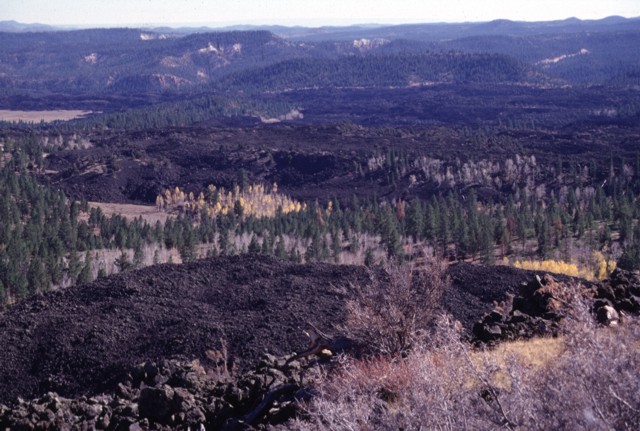
The vast San Francisco Volcanic Field in northern Arizona has more than 550 vents, the youngest of which is Sunset Crater, named for its brilliantly colored scoria deposits on the cone. The eruptions forming the 340-m-high Sunset Crater cinder cone were initially considered from tree-ring dating to have begun between the growing seasons of 1064-1065 CE; however, more recent paleomagnetic evidence places the activity between about 1080 and 1150 CE. The largest vent, Sunset Crater itself, was the source of the Bonito and Kana-a lava flows that extended about 2.5 km NW and 9.6 km NE, respectively. Additional vents along a 10-km-long fissure extending SE produced small spatter ramparts and a 6.4-km-long lava flow to the east. Ash and lapilli covered an area of more than 2,100 km2 and forced the abandonment of settlements of the indigenous Sinagua Indians.
— Smithsonian Institution, Global Volcanism Program
1 Recorded Eruption
| Year | VEI | Type | Area |
|---|---|---|---|
| 1075 | 4 | Confirmed Eruption | Sunset Crater and SE-trending fissures |
Real-Time Data
Frequently Asked Questions About San Francisco Volcanic Field
Is San Francisco Volcanic Field an active volcano?+
San Francisco Volcanic Field is not currently classified as active. Its activity evidence is listed as "Eruption Dated." The last known eruption was in 1075 CE. However, no volcano is ever considered permanently extinct.
When did San Francisco Volcanic Field last erupt?+
The most recent recorded eruption of San Francisco Volcanic Field occurred in 1075 CE with a Volcanic Explosivity Index (VEI) of 4. The eruption was classified as a "Confirmed Eruption." San Francisco Volcanic Field has 1 recorded eruption in total.
How high is San Francisco Volcanic Field?+
San Francisco Volcanic Field has a summit elevation of 3,850 meters (12,632 feet) above sea level. At 3,850 meters, it is comparable in height to many significant mountain peaks and stands well above the tree line.
What type of volcano is San Francisco Volcanic Field?+
San Francisco Volcanic Field is classified as a Volcanic field. Volcanic fields consist of clusters of small volcanic vents and cinder cones spread across a region. Rather than a single central vent, eruptions can occur at many points across the field.
Where is San Francisco Volcanic Field located?+
San Francisco Volcanic Field is located in United States, in the North America Volcanic Regions. More specifically, it lies within the Basin and Range Volcanic Province. Its exact coordinates are 35.347° latitude, -111.678° longitude.
Is it safe to visit San Francisco Volcanic Field?+
San Francisco Volcanic Field can generally be visited, but as with any volcano, visitors should check local conditions and any advisory notices before traveling. United States may have specific regulations for accessing volcanic areas. Guided tours are often the safest and most informative way to experience a volcano.