About Kaguyak
Kaguyak is a lava dome(s) rising to 901 meters (2,956 feet) in United States's North America Volcanic Regions. The volcano is currently active, with its most recent eruption in 3850 BCE. The volcano has produced 2 recorded eruptions, with a maximum Volcanic Explosivity Index (VEI) of 5.
Geography & Climate
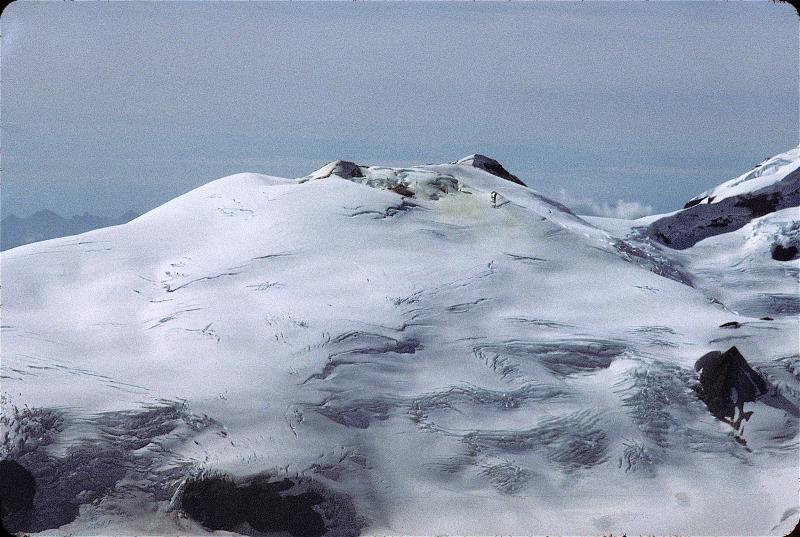
Kaguyak is located in United States, within the Alaska Peninsula Volcanic Arc of the broader North America Volcanic Regions. Situated at 58.61° N, 154.02° W in the Northern Hemisphere, the volcano lies within a subarctic climate zone. With a summit elevation of 901 meters above sea level, Kaguyak is a moderately sized peak that remains accessible to hikers and researchers for much of the year. The volcanic landform is characterized as a caldera, which describes the physical shape and structure of the volcanic edifice as observed from the surface.
Geological Context
Kaguyak sits in a subduction zone, where one tectonic plate dives beneath another, creating intense heat and pressure that generates magma. Subduction zones are responsible for many of the world's most explosive volcanoes and deadliest eruptions. For communities in United States near Kaguyak, this tectonic setting means the volcano is capable of producing powerful explosive eruptions, pyroclastic flows, and lahars that can threaten populated areas within tens of kilometers of the summit. The dominant rock type is dacite, an intermediate to silica-rich volcanic rock. This composition typically produces more viscous magma, leading to more explosive eruptions with ash columns and pyroclastic flows. Andesitic and dacitic magmas build pressure before erupting, which is why volcanoes with this rock chemistry are often associated with Plinian-style eruptions that can send ash tens of kilometers into the atmosphere and disrupt aviation across entire regions.
Eruption History Summary
Kaguyak has 2 recorded eruptions in the geological database, spanning from 4060 BCE to 3850 BCE. The most powerful recorded event was a paroxysmal eruption with devastating regional consequences in 3850 BCE, reaching VEI 5 on the Volcanic Explosivity Index. These eruptions span roughly 210 years of volcanic history.
Significance
With a maximum recorded VEI of 5, Kaguyak has demonstrated the capacity for paroxysmal eruptions comparable to the 1980 eruption of Mount St. Helens. Eruptions of this scale can devastate areas within 20-30 kilometers and produce ash fall that disrupts aviation and agriculture across hundreds of kilometers.
GVP Reference Summary
The 2.5-km-wide Kaguyak caldera in the NE part of Katmai National Park is filled by a lake more than 180 m deep whose surface lies 550 m below the caldera rim. The volcano rises directly from lowland areas near sea level south of the Big River. Initially considered to be a typical stratovolcano truncated by a caldera, the pre-caldera edifice has been shown to consist of nine contiguous late-Pleistocene lava dome clusters, most of which lie east of the present caldera. A large post-caldera lava dome extends into the lake on the SW side and another dome forms a small island in the center of the lake. The caldera is unglaciated, and distal tephras from the caldera-forming eruption have been radiocarbon dated at about 5,800 years before present. Voluminous dacitic pyroclastic-flow deposits surround the caldera and reached Shelikof Strait to the SE.
— Smithsonian Institution, Global Volcanism Program
2 Recorded Eruptions
| Year | VEI | Type | Area |
|---|---|---|---|
| 3850 BCE | 5 | Confirmed Eruption | Kaguyak caldera |
| 4060 BCE | — | Confirmed Eruption | — |
Real-Time Data
Frequently Asked Questions About Kaguyak
Is Kaguyak an active volcano?+
Kaguyak is not currently classified as active. Its activity evidence is listed as "Eruption Dated." The last known eruption was in 3850 BCE. However, no volcano is ever considered permanently extinct.
When did Kaguyak last erupt?+
The most recent recorded eruption of Kaguyak occurred in 3850 BCE with a Volcanic Explosivity Index (VEI) of 5. The eruption was classified as a "Confirmed Eruption." Kaguyak has 2 recorded eruptions in total.
How high is Kaguyak?+
Kaguyak has a summit elevation of 901 meters (2,956 feet) above sea level. At 901 meters, it is a relatively low-elevation volcano.
What type of volcano is Kaguyak?+
Kaguyak is classified as a Lava dome(s). Lava domes are mounds of viscous lava that pile up around a volcanic vent. They grow by expansion from within and can collapse to produce dangerous pyroclastic flows.
Where is Kaguyak located?+
Kaguyak is located in United States, in the North America Volcanic Regions. More specifically, it lies within the Alaska Peninsula Volcanic Arc. Its exact coordinates are 58.611° latitude, -154.024° longitude.
Is it safe to visit Kaguyak?+
Kaguyak can generally be visited, but as with any volcano, visitors should check local conditions and any advisory notices before traveling. United States may have specific regulations for accessing volcanic areas. Guided tours are often the safest and most informative way to experience a volcano.